For today’s 14-day rainfall outlook – scroll to bottom of article
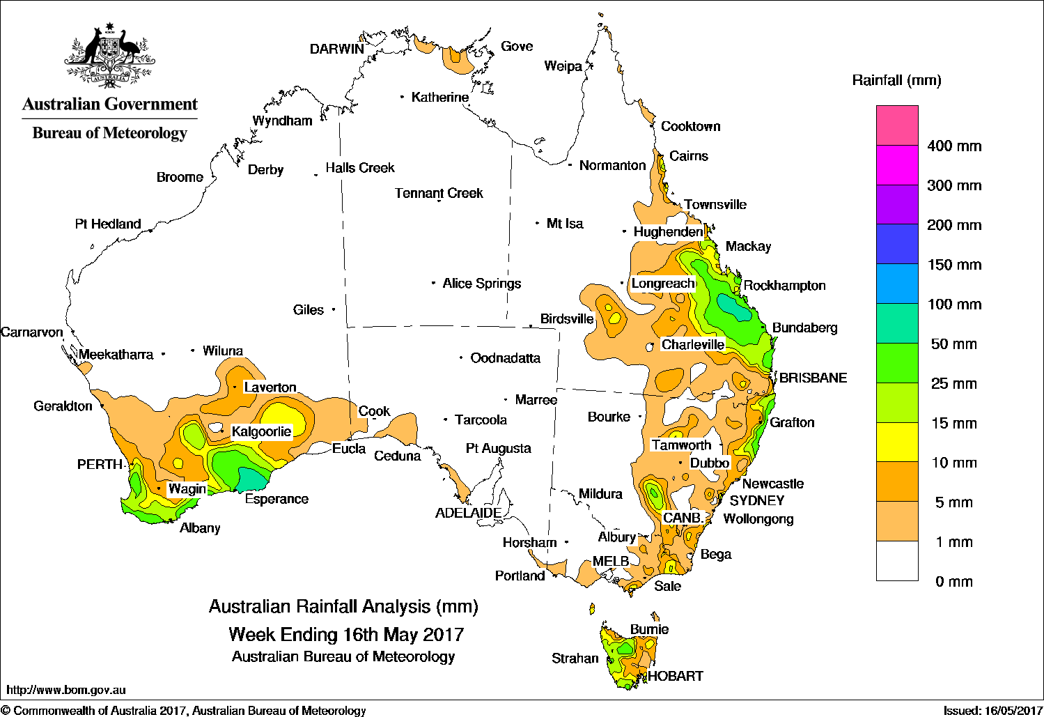
In another dry week across most of Australia, the highest falls were recorded in southern Western Australia, Tasmania, eastern Victoria, parts of central and eastern New South Wales, and in central and southeastern Queensland.
Past seven days: At the start of the week a surface and upper-level trough produced showers and thunderstorms with moderate falls across parts of central eastern Queensland. A cloudband associated with a cold front and surface trough tracked across southern Western Australia, bringing moderate falls.
In the middle of the week, a small low pressure system and surface trough tracked over northern Tasmania. Thunderstorms and showers produced moderate falls in the northwest, while light falls were recorded across remaining parts of Tasmania.
At the end of the week, broad low pressure troughs located through inland eastern Australia and off the east Australian coast produced showers and thunderstorm activity. This activity produced moderate falls in parts of southern and eastern New South Wales, eastern Victoria, and across large parts of the southern interior of Queensland.
In the west, a vigorous cold front and associated low pressure system crossed southern Western Australia. Moderate falls were recorded along the southwest tip of Western Australia. Widespread light rainfall was reported over much of the South West Land Division and Southeast Coastal district.
Rainfall totals in excess of 50 mm were recorded around Esperance in Western Australia, and in parts of the Capricornia district in central Queensland.
Rainfall in excess of 10 mm were recorded in the southern South West Land Division, southern Goldfields district, and south coast in Western Australia; most of the western half of Tasmania; pockets of southern and eastern Victoria; an area of the central interior and along the northeastern coast in New South Wales; also in the Central Highland and Coalfields, Capricornia and southeastern districts of Queensland.
Little or no rainfall was recorded in remaining parts of Western Australia, South Australia and the Northern Territory, the northern two thirds of Western Australia; also the western halves of Victoria, New South Wales, and Queensland.
Highest weekly totals
New South Wales and Australian Capital Territory
116 mm Minnie Water
57 mm Evans Head RAAF
56 mm Fishermans Reach
Victoria
24 mm Toora
18 mm Cabbage Tree Creek
17 mm Dellicknora (Tellicura)
Queensland
178 mm Sandy Cape Lighthouse
73 mm Lovandee
68 mm Lady Elliot Island
Western Australia
72 mm Beaumont West
68 mm Bremer Bay
63 mm The Duke
South Australia
19 mm Athelstone (Black Hill)
6 mm Coffin Bay
4 mm Coulta (Coles Point)
Tasmania
39 mm Bicheno (Council Depot)
37 mm Railton (Dowbiggin Street)
31 mm Sheffield School Farm
Northern Territory
7 mm Milingimbi Airport
4 mm Warruwi Airport
2 mm Alcan Minesite
More weekly rainfall totals:
- NSW/ACT totals click here
- Vic totals click here
- Qld totals click here
- WA totals click here
- SA totals click here
- Tas totals click here
- NT totals click here
Source: BOM


HAVE YOUR SAY