For today’s 14-day rainfall outlook – scroll to bottom of article
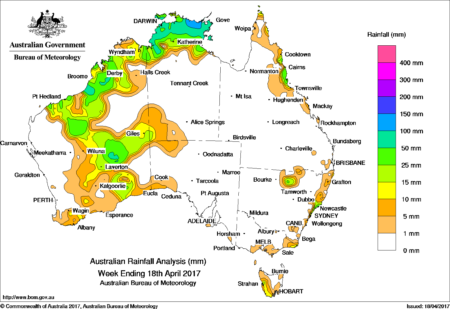
Rainfall during the past week was recorded across the Top End and far southwest of the Northern Territory; northern, central and southern parts of Western Australia; western Tasmania; coastal New South Wales and a small pocket in the north of the State, and in the far northeast of Queensland.
Past seven days: At the start of the week, an active monsoon trough was located across the north of Australia, with a developing tropical low north of Darwin. The low triggered thunderstorms and showers over the Top End of the Northern Territory, and the northern Kimberley in Western Australia.
A ridge extended over the east coast, whilst a complex low pressure system moved southeast over New South Wales, then into the Tasman Sea. The low pressure system produced moderate falls in a small area of the Hunter region, and mainly light falls along parts of the east coast of New South Wales.
From the mid-week, the tropical low weakened as it moved southwest through the northwest Northern Territory, the Kimberley and the Pilbara coast. The system produced showers and thunderstorms with moderate totals recorded in the Kimberly and the Pilbara coast and adjacent inland areas. A surface trough deepened near the west coast of Western Australia. The trough and associated cloudband produced thunderstorms with moderate falls from inland Pilbara, Goldfields to the Southern Interior of Western Australia, with mainly light falls along the south coast of Western Australia, southwestern Northern Territory, and western parts of South Australia. During the last part of the week, a moist, onshore flow produced moderate falls about the north tropical coast district between Cooktown and Ingham in Queensland.
A series of cold fronts tracked across Tasmania during the week, producing light falls in western Tasmania.
Rainfall totals between 100 mm and 200 mm were recorded in parts of Arnhem Land in the Top End, including the highest weekly rainfall total of 191 mm at Milingimbi Airport in the Northern Territory.
Rainfall totals between 50 mm and 100 mm were recorded in areas of the western Kimberley and central interior of Western Australia, and the Darwin–Daly and Arnhem Land districts of the Northern Territory; and a small area of the Hunter regional in New South Wales.
Rainfall totals between 10 mm and 50 mm were recorded in remaining parts of the Top End and the far southwest of the Northern Territory; large areas of the north and central and small areas of the southwest of Western Australia; western Tasmania; a small area of East Gippsland in Victoria; about the central east coast and in an isolated pocket of northern New South Wales, and in the north tropical coast district and far north of the Cape York Peninsula in Queensland.
Little or no rainfall was recorded in the west, and the northern and southern interior of Western Australia; most of the Northern Territory except the Top End and the far southwest; Queensland away from the north east coast district; most of New South Wales and Victoria away from the east, and Tasmania except in the southwest.
Highest weekly totals
New South Wales and Australian Capital Territory
60 mm Careys Peak (Barrington Tops)
59 mm Newcastle
53 mm Williamtown RAAF
Victoria
31 mm Mallacoota
27 mm Gabo Island Lighthouse
18 mm Point Hicks (Lighthouse)
Queensland
68 mm Hawkins Creek
51 mm Cardwell Range
48 mm Bingil Bay
Western Australia
64 mm Anna Plains
63 mm Tjukayirla
62 mm Debesa
South Australia
7 mm Ernabella (Pukatja)
6 mm Robe, Nullarbor
Tasmania
25 mm Mount Read
19 mm Tim Shea (Summit)
13 mm Multiple locations
Northern Territory
191 mm Milingimbi Airport
145 mm Maningrida Airport
106 mm Ngayawili
More weekly rainfall totals:
- NSW/ACT totals click here
- Vic totals click here
- Qld totals click here
- WA totals click here
- SA totals click here
- Tas totals click here
- NT totals click here
Source: BOM


HAVE YOUR SAY