For today’s 14-day rainfall outlook – scroll to bottom of article
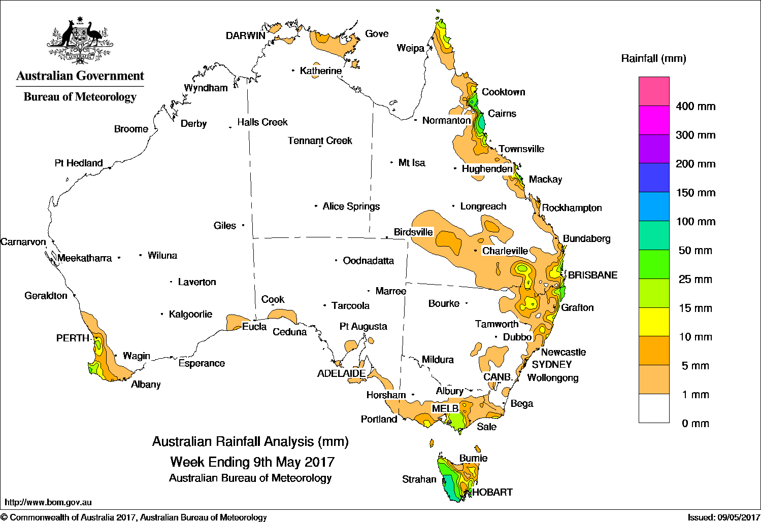
It was a largely dry week across the continent, with the only areas recording 25mm or more being southwestern Tasmania, northeastern New South Wales, the central and north tropical Queensland coast and pockets of southwest Western Australia.
Past seven days: At the start of the week, a westerly flow produced moderate falls in western Tasmania, and light falls were reported in southern parts of Victoria; also southern South Australia. A surface trough located through inland Queensland produced moderate rainfall totals in the southern interior of Queensland and northeastern New South Wales. A cold front produced light to moderate rainfall totals in southwest Western Australia.
From the middle of the week, a high pressure system moved across southern Australia into the Tasman Sea, establishing a firm ridge along eastern Queensland. A moist onshore airflow brought showers with moderate rainfall totals in the north tropical coast and pockets of the east coast of Queensland.
A vigorous cold front and associated deepening low pressure system tracked across southeastern Australia, in the wake of the high pressure system moving eastward. Light falls associated with the passage of the cold front were recorded in southwest Western Australia. As the system continued its eastwards track, showers and thunderstorms produced moderate falls in southern Victoria and western Tasmania.
At the end of the week, a moist, east to southeasterly airflow brought showers and moderate falls to parts of southeastern Queensland and northeastern New South Wales.
Rainfall totals exceeding 50 mm were recorded in southwestern Tasmania, northeastern New South Wales and the north tropical Queensland coast, including the highest weekly total of 102 mm at Bingil Bay in Queensland.
Rainfall totals between 25 mm and 50 mm were recorded in pockets of southwest Western Australia, in western and southeastern Tasmania, pockets of northeastern New South Wales, and about the Capricornia and north tropical coasts of Queensland
Rainfall totals between 10 mm and 25 mm were recorded in western, southeastern and northeastern Tasmania; central and southern Victoria; southwest Western Australia; northeastern New South Wales, and in near coastal parts of southeast and northeast Queensland.
Little or no rainfall was recorded in most of the Northern Territory; South Australia; Western Australia away from the southwest tip; much of Queensland away from the east coast, southern interior and southeast; New South Wales except the northeast, and in northern, western and eastern Victoria.
Highest weekly totals
New South Wales and Australian Capital Territory
63 mm Ballina Airport AWS
58 mm Byron Bay (Jacaranda Drive)
49 mm Byron Bay (Cape Byron AWS)
Victoria
34 mm Mount Baw Baw
31 mm Ferny Creek
30 mm Main Ridge
Queensland
102 mm Bingil Bay
89 mm South Johnstone Exp Stn
76 mm Tully Sugar Mill
Western Australia
31 mm Witchcliffe
30 mm Cowaramup
25 mm Margaret River
South Australia
8 mm Goolwa Council Depot
6 mm Bridgewater
5 mm Kingston, Flinders Chase (Rocky River), Parawa (Sharon)
Tasmania
85 mm Mount Read
70 mm Lake Margaret Power Station
68 mm Port Arthur (Stewarts Bay)
Northern Territory
7 mm Maningrida Airport
5 mm Milingimbi Airport
4 mm Gunn Point, Alcan Minesite
More weekly rainfall totals:
- NSW/ACT totals click here
- Vic totals click here
- Qld totals click here
- WA totals click here
- SA totals click here
- Tas totals click here
- NT totals click here
Source: BOM


HAVE YOUR SAY