ANOTHER rain front crossing the Western Australian grainbelt is consolidating the excellent start to the grain growing season in WA, setting the scene for another potentially record crop.
All regions of the state have received top-up rain recently and this has continued to drive tonnage estimates up.
In its latest crop report, the Grain Industry Association of WA (GIWA) says the very wet areas in the south-west and south coast of WA are now becoming very, very wet and tonnage estimates are down at least 10 to 15 per cent in the southern areas of the Albany Port zone and the coastal strip in the Esperance Port Zone. But, the solid crops across the rest of the state will make up the difference to neutralize the impact on total grain production for WA.
Total winter rainfall to date has only been equal to, or slightly less than the median (middle point) for the last 45 years for most of the grain growing regions. This is except for the south coastal region.
GIWA crop report author, Mike Lamond, said the reasons behind the positive outlook were more to do with the early start, the level of subsoil moisture from autumn rains, the very good growing conditions, and the large area of crop; a combination of factors that do not come together often.
He said current tonnage estimates for the state are conservative as crops still have to make it through the inevitable frost that can shave off significant tonnage in the spring.
Most regions will still require a reasonable spring with close to average rainfall and average temperatures to minimize the impact of heat shock on final grain yields.
Mr Lamond said whilst there still was risk of grain tonnages falling away, with the very large total area sown this year, coupled with the good growing conditions right across all zones, it was hard to see how the state wouldn’t be in for a record total tonnage.
“This combined with even average conditions going forward means it could be a record by a substantial margin.”
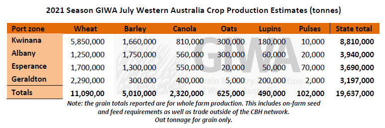
The large areas of wheat in the low rainfall regions of the Geraldton, Kwinana and Esperance Port Zones are in better shape this year than they have been since 2016 which was a record tonnage year.
The 10.6 million tonnes (Mt) of wheat that was produced in 2016 was from just under 4.5 million hectares.
There is 14 per cent more wheat area this year than in 2016 and the increase in area sown to wheat in 2021 will have a big impact on the final total grain production.
Barley and canola area estimates have come back slightly from last month due to lost areas to waterlogging. Whilst these wet areas are now likely to obtain only average grain yields, the grain yield potential for barley and canola is still very good for the remainder of the state’s crop.
The total oat area is down on previous years due to the reduction in area sown for hay.
However, the tonnage outlook for oat grain is well up on recent years due to very good growing conditions in areas where oats are grown.
This includes more area planted in the medium to low rainfall regions where there were early planting opportunities, reasonable prices, and the swing out of hay to grain for the dedicated hay growers.
Lupin area is down due to the strong canola prices at planting time. Crops in the central and north of the state are very good whilst in the southern regions, they have much lower grain yield potential due to the cold wet growing conditions.
Zone-by-zone
Geraldton Zone
The crops in the Geraldton Port Zone are looking very good. All crops are further advanced for this time of the year than they have been for a while. Subsoil moisture reserves are not as good as areas further south although, the early planting and fast growth to date means there is less risk of significant yield penalty from heat shock if the season cuts out early. The region will still need a reasonable spring to get crops over the line and to hit the tonnages estimated in this report. If there is an average finish to the season, there is upside potential for all crops.
Crops in the low rainfall regions in the east of the zone are the best they have been for many years and have well above average grain yield potential at this stage of the season. Frost is still a risk in the region and top end potential grain yield may be limited by the restricted availability of nitrogen fertiliser for some growers.
Kwinana Zone
Kwinana North Midlands
Growing conditions in the zone are good in the west to very good in the east. Crops are clean from weeds and disease and have put on a lot of growth for this time of the year. The early start has resulted in crops at a wide range of growth stages, and this will help to mitigate the loss of large tonnages from frost and heat stress in the spring. Rain is still the most limiting factor for the region as most areas will still need it to keep raining to achieve the above average grain yield potential that is there at present.
The tight nitrogen fertiliser supply up until now, brought about in part by increased demand and earlier application timings, is a strong indication of growers perception of grain yield potential. Some crops on the lighter soils, and particularly those which followed large crops in 2020, are starting to show the signs of nitrogen deficiency.
Kwinana South
The whole region is now in very good shape for above average grain yields if rainfall for the next two months is close to average. The dry area in the central part of the zone along the Great Eastern Highway has recently received some good falls following a very dry June. The western areas are starting to become too wet to get on to spray and fertilise, although the grain yield potential has not been impacted yet as it has been further south.
There is a very wide range of crop growth stages which will help to reduce the impact from threats such as frost and heat in the spring. The very early sown canola and barley looks sensational, and the later sown crops have picked up in the last few weeks due to the very mild growing conditions.
Kwinana North East
The drier areas of the Kwinana zone are having a very good year. Adequate levels of subsoil moisture from autumn rains and crops sown into moisture from early rains has the region looking forward to one of the best years for a while. Weed control has been excellent and leaf disease is very low to date.
Many growers are in unfamiliar territory with such a good start and unsure how much to push crops knowing that things can turn around very quickly.
With the massive area of crop sown in the region and current condition of the crops, it is difficult not to get excited for those growers who have had some very lean years in recent times.
Albany Zone
Albany West
The zone is now very wet and with more rain to come over the next few days, significant loss of crop is expected from waterlogging. Kojonup and Kendenup have had near record rainfall to date and much of the lower lying areas of paddocks have lost crop.
There are some huge differences in crop grain yield potential with some of the well-drained higher country that went in early “the best ever” and the later sown low country very poor. The tail end of most crop programs were abandoned with only a paddock or two to go, which reduced the intended crop area slightly. Now with the crop loss and reduced paddock averages from waterlogging, the total tonnage estimated from the region will be closer to average.
Albany South
Some areas of the region were hit hard by severe storms which caused significant damage to individual paddocks in the worst hit areas. The greater impact however is general waterlogging across the whole region which has resulted in areas of crop death and areas that will require re-seeding when it dries out enough to get back on paddocks. These re-sown areas will produce well below average grain yield. A lot of paddocks are not trafficable, and crops have been impacted from the inability to apply nitrogen and control weeds.
The net result for the region is likely to be below average total tonnage for all crops.
Albany East
Wheat in the Lakes region is good, barley is impressive, and canola is looking amazing. Soil moisture reserves from autumn are greater than normal and winter rainfall about average to date. Some crops required re-seeding due to big dumps of rain soon after seeding, although, the affected area is small and most crops have very good establishment, setting them up for above average grain yield potential.
There is a big spread in crop maturity even though the whole zone received early rains conducive to planting. This was a planned move by many growers and represents a major practice change for the region since 2016 where frost took a massive toll on crop yields. More oats and barley are now planted in the low areas and the spread in planting dates mean the risk of crop loss is less.
If the season continues along the same vein as it has to date, the region will produce some good crops. Weed control has been very good and crops are the cleanest they have been for a while. Spot Type Net Blotch in barley, and for those growing Bonito, blackleg in canola is just starting to get going. Many growers are now applying an anti-feed for aphid control in cereals.
Esperance Zone
Crops in the Esperance Zone are in excellent condition from top to bottom. The only downside is some of the wetter areas close to the coast are starting to show signs of waterlogging. Crop development is above average and well advanced for this time of the year. There is a noticeable range in crop development particularly in the frost-prone parts of the landscape.
The early crops have bulked up from the good growing conditions and are now needing fungicide sprays for disease and early sprays for aphids. Nitrogen use has been higher than usual due to the above average crop potential and good prices.
The region has seen an increase in deep ripping and the deep ripped gravelly sands have really shown up this year as having been less impacted by waterlogging.
Seasonal Outlook
The WA Department of Primary Industries and Regional Development’s Ian Foster said June rainfall was well below average for most of the cropping area, apart from the South Coast, where heavy rain added significantly to waterlogging issues and local flooding.
Seasonal rain for April to June was near average or wetter for most regions, and much wetter for the South Coast (see Figure 1).
Soil water storage is near average or slightly lower than normal in central areas, again apart from the South Coast.
Climate conditions in the Pacific Ocean are likely to remain neutral for the rest 2021.
The Indian Ocean Dipole (IOD) has been negative for the past six weeks, and most models now predict this to continue for the rest of the growing season.
This state is associated with wetter conditions over southern Australia, though there is a wide spread of outcomes for Western Australia.
Most climate models have neutral rainfall outlooks for the next three months over southern WA, although a few models indicate below-normal seasonal rain is more likely. Local factors such as ocean temperatures may have greater influence on rain events in the short term.
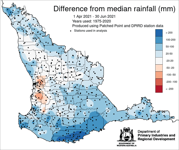
Figure 1: Rainfall for April to June 2021, shown as difference from median rain (in mm) for that period. (Source: DPIRD)
Bureau of Meteorology seasonal outlook summary
July to September rainfall is likely to be above median for most of Australia, though areas in western WA, coastal south-east Australia, and western Tasmania are tending towards a more neutral rainfall outlook. July and August rainfall show a similar pattern though the chances of exceeding the median are not as high in August.
Maximum temperatures for winter are likely to be above average for northern, south-western, and south-eastern Australia.
Minimum temperatures for winter are very likely to be above average for most of Australia. Parts of western WA show a more neutral outlook. The pattern is similar to the June minimum.
Large parts of the eastern Indian Ocean are warmer than average, and a IOD event is looking increasingly likely, which can favour above average rainfall for parts of Australia. The El Niño–Southern Oscillation is currently neutral.
Source: GIWA
Grain Central: Get our free cropping news straight to your inbox – Click here


HAVE YOUR SAY