Thunderstorms and showers in the northern tropics and east of Australia as Ex-tropical cyclone Anika generated thunderstorms and heavy rainfall over the interior of Western Australia.
Weekly highlights
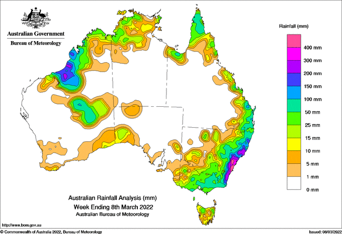
For the week to 8 March 2022, rainfall was recorded in the Kimberley and areas of the Pilbara, the Interior District, and in areas in the south and south-west of Western Australia; in parts of the northern Northern Territory; in northern, central-coastal and south-east Queensland; in New South Wales apart from the far north-west, and across most of Victoria and Tasmania. Mostly light rainfall was also recorded in small areas in the north-west and south of South Australia.
During the first part of the week, ex-tropical cyclone Anika briefly re-developed into a tropical cyclone while off the Kimberley coast, before crossing the coast near Wallal. It continued moving through the Kimberley while gradually weakening. Tropical convection was scattered across the Top End and Cape York Peninsula resulting in moderate to heavy rainfall, while a trough and developing low were located off the northern New South Wales coast.
In the middle of the week, ex-tropical cyclone Anika generated thunderstorms, heavy rainfall and damaging winds over the interior of Western Australia. An East Coast Low developed near the Mid-North coast of New South Wales and, while moving south towards the central parts of the New South Wales coast, the system brought rain, strong winds and large surf, before weakening. A low pressure surface trough and associated upper low moved slowly across Victoria bringing moderate to heavy rainfall, mostly to the central parts of the state.
In the last part of the week, isolated thunderstorms were spread across the Kimberley, the Top End, and the Cape York Peninsula. A cold front moved across south-east New South Wales, bringing rainfall to the South-West Slopes and Central Tablelands districts, while a low pressure trough extended from the far north of Western Australia, through the Northern Territory, central Queensland and to the New South Wales central coast. A deepening low pressure system over northern New South Wales generated thunderstorms, some of which were severe.
Weekly rainfall totals in excess of 100 mm were recorded in parts of north-west Western Australia and along most of the New South Wales coast. Some isolated local totals in excess of 100 mm were also recorded at sites in the north of Cape York Peninsula and in parts of coastal south-east Queensland. The highest weekly rainfall total was 816 mm at Beaumont in the Illawarra in New South Wales.
Rainfall totals between 50 mm and 100 mm were recorded in the north-west Kimberley and much of the remainder of the Pilbara, parts of the Interior District in Western Australia; parts of the west and north of the Top End in the Northern Territory; northern Cape York Peninsula and coastal south-east Queensland; across most of eastern New South Wales surrounding higher totals; and in most of eastern and central Victoria.
Rainfall totals between 10 mm and 50 mm were recorded in areas in the south and south-west of Western Australia, in small areas in the north-west and south of South Australia, and in much of Tasmania.


HAVE YOUR SAY