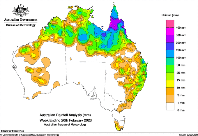
TROPICAL low activity in the Gulf of Carpentaria brought heavy rainfall during the week to surrounding areas of Cape York Peninsula, the Queensland Gulf Country and central and eastern regions of the Northern Territory.
 The heaviest falls, with weekly rainfall totals of 200-300mm, were recorded in the lower Cape York Peninsula and along the Qld tropical coast from Cairns to Innisfail.
Areas of the Queensland Gulf Country, northern Cape York Peninsula and parts of the NT recorded weekly totals of 100-200 mm, and most of the rest of northern Australia recorded 25-100 mm.
Storms along the New South Wales coast, notably around Sydney, and into southern Queensland resulted in widespread weekly totals of 25-50 mm, with higher totals locally.
The highest weekly total at a Bureau gauge was 358mm at Tung Oil Alert near Innisfail, Qld, including the highest daily total of 202mm on February 17.
Moderate flooding continues on several Queensland rivers, but in NSW, flood warnings have been finalised for the Lachlan River.
Summer 2022-23 rainfall for north-eastern NSW and south-eastern Queensland has so far been very much below average, and is in the driest 10 percent of all summers since 1900.


HAVE YOUR SAY