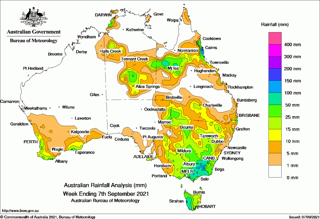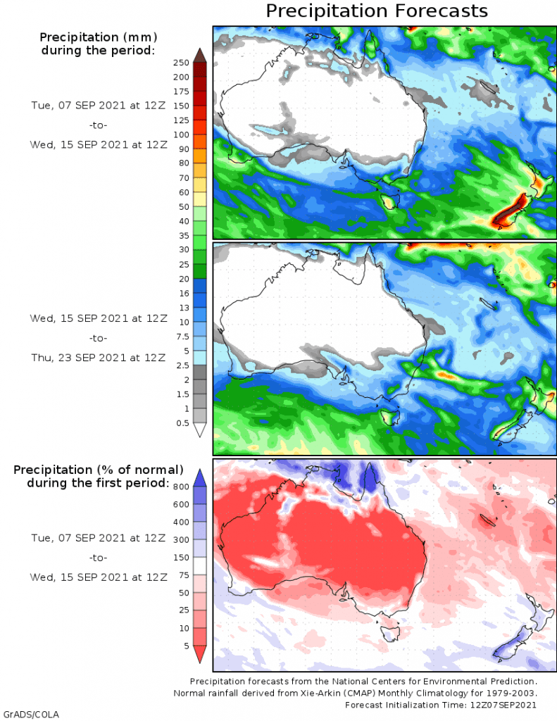
RAINFALL was widespread across the continent through the week, including the central regions of the Northern Territory and inland Queensland and New South Wales.
Light to moderate falls were recorded through most of the agricultural regions, except in Queensland.
Past seven days: For the week to 7 September 2021, rainfall was recorded in most of Victoria and Tasmania, and much of New South Wales excluding the central coast, north-eastern and western districts. Rainfall was also recorded in areas of Queensland’s north, south and along the east coast from the north tropical coast to the south-east; the north-western, central and southern parts of the Northern Territory; the north-east, central east and south-eastern coast in South Australia, and along the west and south coast in Western Australia.
At the start of the week, an upper-level trough brought showers and thunderstorms with moderate falls, along the north tropical to central Queensland coast. Locally heavy daily falls in excess of 100 mm were recorded in the north tropical coast. Light to moderate falls extended inland to the Northern Goldfields District.
A cold front tracked across the south-east of Australia, and produced light to moderate rainfall to Tasmania, the south-east coast of South Australia, and the south-west coast of Victoria.
A trough developed and extended across the north-west of Queensland and the eastern border of the Northern Territory to produce thunderstorms and showers in those regions. Onshore flow produced showers in the south-east coast of Queensland and far north-east coast of New South Wales.
In the west, a strong cold front moved across the south-west of Western Australia, while a trough and cloudband extended from the north-west down to the southern parts of the state, to bring light rainfall to the south-west quarter of Western Australia, with moderate falls confined along the coastal areas.
During the middle of the week, the cold front tracked across South Australia. A trough, ahead of the cold front developed and extended across the inland Northern Territory, south-west Queensland and the north-east of South Australia. The pre-frontal trough and cold front moved east across south-east Australia, and southern Queensland. A weak low pressure system developed in the eastern Victoria then moved offshore, along with the frontal system.
Widespread moderate rainfall was recorded in most of Victoria, much of the New South Wales excluding the north-east, the inland southern Queensland, the central and southern parts of the Northern Territory, and eastern and south coastal parts of south Australia. Daily rainfall in excess of 50 mm to 70 mm was recorded in the West and East Gippsland districts in Victoria on the weekend.
At the last part of the week, a weak cold front brought light rainfall in the far south-east of Australia, with moderate rainfall recorded in the western Tasmania, central Victoria, and inland southern New South Wales. Onshore flow produced showers in the north tropical coast in Queensland.
Rainfall totals in excess of 100 mm were reported in the north tropical coast in Queensland, and the West and East Gippsland districts in Victoria. The highest weekly rainfall total of 264 mm was recorded at Mt Sophia in Queeensland, and the daily rainfall of 233 mm on the 1st was a new September daily rainfall record at this site.
Rainfall totals between 50 mm and 100 mm were recorded in eastern and central Victoria, the south-west slopes in New South Wales, the western parts of Tasmania, and the north-west and north tropical coast of Queensland.
Rainfall totals between 10 mm and 50 mm were recorded in the south-west, south coast, and pockets in the Gascoyne in Western Australia; central and southern parts of the Northern Territory, and the east and south coast of South Australia. Similar totals were recorded in the inland north and south, and along east coast parts of Queensland; much of New South Wales away from the central coast and the north-east; most of Victoria, and Tasmania.
Highest weekly totals
New South Wales and Australian Capital Territory
119 mm Thredbo Aws
94 mm Khancoban Aws
82 mm Cabramurra Smhea Aws
Victoria
116 mm Mount Baw Baw
112 mm Mount Moornapa
111 mm Mount Nowa Nowa
Queensland
264 mm Mt Sophia
175 mm Tully Sugar Mill
118 mm Babinda Post Office
Western Australia
36 mm The Duke
34 mm Northcliffe
33 mm Multiple locations
South Australia
27 mm Parawa (Second Valley Forest A
23 mm Cape Borda, Pinnaroo
Tasmania
88 mm Mount Read
83 mm Lake Margaret Power Station
71 mm Low Rocky Point
Northern Territory
46 mm Dum In Mirrie Airstrip


HAVE YOUR SAY