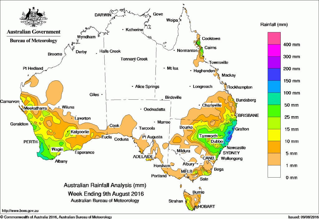
The best falls of the west week were recorded in western and southern Western Australia and the northeast quadrant of New South Wales.
Past seven days: At the start of the week, a low pressure system developed on the northern New South Wales coast generating moderate to heavy rainfall in far southeastern Queensland, and northeastern New South Wales as the system tracked east into the Tasman Sea.
In the west, a slow moving trough near the west coast combined with a cold front which brought widespread light falls to western parts of Western Australia and moderate rainfall in parts of the Gascoyne and southwest.
From the middle of the week onwards, a deep low pressure system south of the Great Australia Bight directed a series of strong cold fronts over western and southern parts of Western Australia, which produced persistent light to moderate rainfall in the South West Land Division.
At the end of the week, a trough and a cloudband tracked across South Australia, which brought light rainfall to southern South Australia, and western Tasmania. A ridge of high pressure along the east coast directed an onshore flow with light to moderate falls in the north tropical coast of Queensland.
100mm-200mm: New South Wales north and central coastlines. The highest weekly total was 274 mm at Meldrum, on the north coast of New South Wales.
50mm-100mm: Southwest coast of Western Australia, the north tropical coast and far southeast of Queensland and northeastern New South Wales.
10mm-50mm: Western and southern parts of Western Australia, southern tips in the South Australia, northeastern in Victoria, western and southern Tasmania. Similar falls were recorded in the eastern to central New South Wales, also in southeast Queensland.
Little to no rain: The Northern Territory, most of South Australia and Victoria, western and southern New South Wales, most of Queensland, and much of Western Australia.
Highest weekly totals
New South Wales and Australian Capital Territory
274 mm Meldrum (Coolawarrah)
208 mm Careys Peak (Barrington Tops)
204 mm Fishermans Reach
Victoria
35 mm Mount Wellington
21 mm Cann River
20 mm Mount Tamboritha
Queensland
85 mm O’Reillys Alert
79 mm Foxley Alert
67 mm Springbrook Road
Western Australia
90 mm Collie
87 mm Aston Downs Alert
81 mm Witchcliffe
South Australia
16 mm Flinders Chase (Rocky River)
14 mm Neptune Island
11 mm Coffin Bay
Tasmania
32 mm Mount Read
18 mm Tim Shea (Summit)
17 mm Scotts Peak Dam
Northern Territory
0.6 mm Centre Island
0.4 mm Gove Airport
More weekly rainfall totals:
- NSW/ACT totals click here
- Vic totals click here
- Qld totals click here
- WA totals click here
- SA totals click here
- Tas totals click here
- NT totals click here
Source: BOM


HAVE YOUR SAY