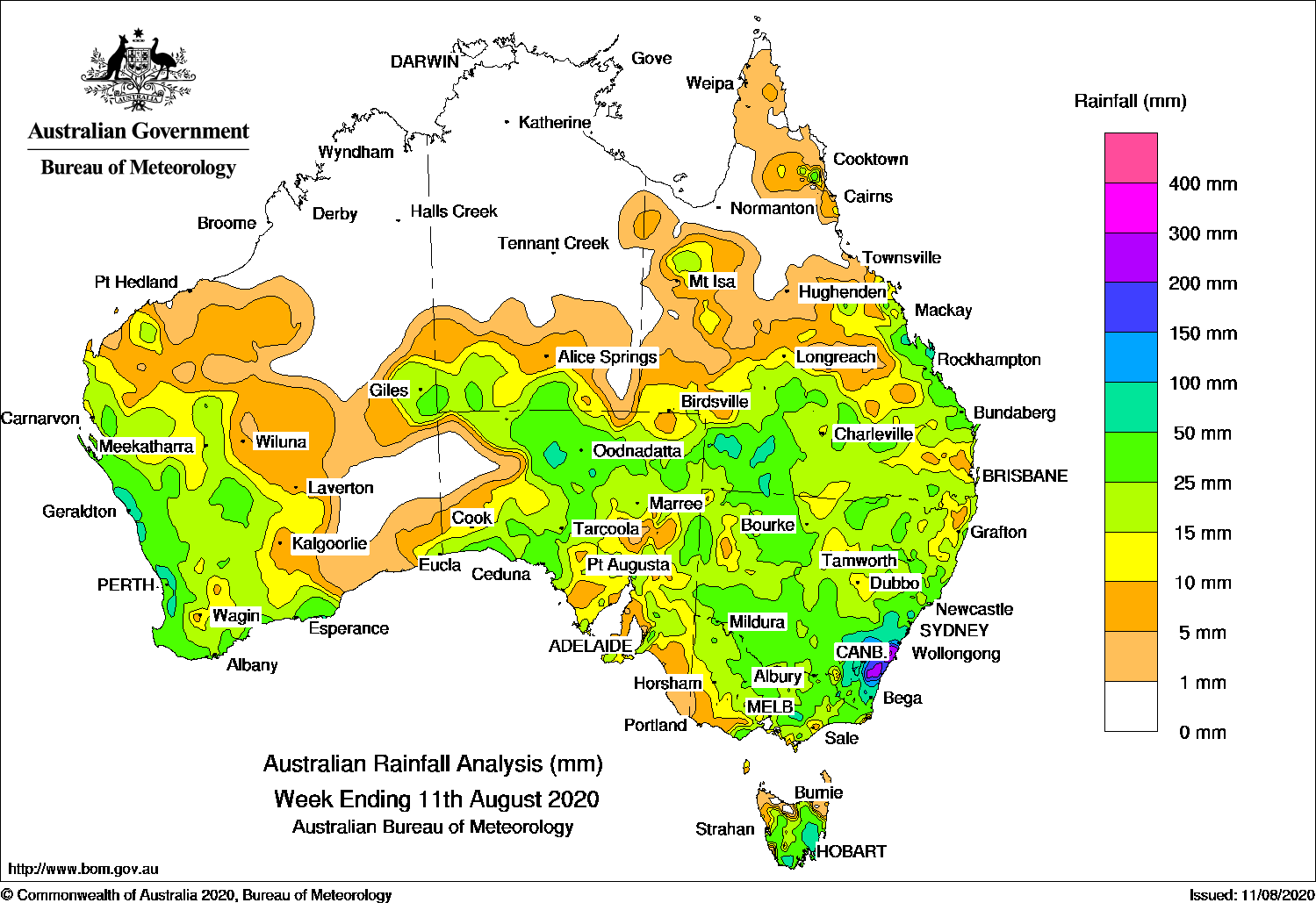
LOW pressure systems, cold fronts and troughs generated widespread moderate falls over the southeast quarter of the continent, while a strong cold front brought moderate falls to western parts of Western Australia.
Past seven days: At the start of the week, a low pressure system moved across southern Western Australia, with localised showers and storms mainly along the south coast. A broad low pressure system developed in western South Australia with an associated trough stretching into central Australia, triggering a rainband over South Australia with embedded thunderstorms producing moderate falls.
Another low pressure system was located to the east of Tasmania, and triggered a cold outbreak over southeastern Australia, with snow falls down to 300 m to 400 m in Tasmania, Victoria and Alpine New South Wales. The low continued to generate showers in Tasmania, Victoria and parts of the New South Wales coast.
During the middle of the week, the low pressure system and trough moved east over South Australia and central Australia, with the associated rainband generating widespread moderate falls over South Australia, the far southern parts of the Northern Territory, southwest Queensland and western New South Wales.
The complex low pressure system, with a frontal system and trough, moved over western Queensland, then western and southern New South Wales. An upper trough over northwest New South Wales, and the associated cold front swept over southeast Queensland, producing showers and thunderstorms over the central Queensland coast, and widespread moderate falls were recorded from central to southeast Queensland, much of New South Wales, northern Victoria and southeast South Australia.
In the last part of the week, the complex low pressure system crossed the New South Wales coast near Gosford, with showers and rain feeding into the southern half of the coast, driven by a mid-level cold trough centred over central northern New South Wales. Moderate falls were recorded along the east coast of New South Wales with heavier falls reported about the Illawarra Coast, and three-day totals to 9am on Monday 10 August exceeding 300 mm around Nowra.
In the west, a strong cold front and associated cloudband tracked over the west coast of Western Australia. Widespread moderate falls were recorded in the western parts of the state from the Pilbara coast and Gascoyne districts, down to most of the South West Land Division in Western Australia. The front and rainband moved eastwards, and brought light to moderate falls to central Australia and southwest South Australia.
Rainfall totals in excess of 200 mm were recorded along the Illawarra and Hunter coasts of New South Wales, including the highest weekly total of 374 mm at Nowra Boat Shed (Shoalhaven River).
Rainfall totals in excess of 100 mm were recorded across most of the South Coast District of New South Wales.
Rainfall totals in excess of 50 mm were recorded along the west coast of Western Australia, in areas of central Australia, southwest and along the central coast of Queensland, pockets of the northwest and much of the southeast of New South Wales, small areas of central Victoria, and southeast Tasmania.
Rainfall totals between 10 mm and 50 mm were recorded from the Pilbara coast to the South West Land Division, along most of the south coast, and inland areas bordering the southwest Northern Territory; southern parts of the Northern Territory; most of South Australia, Victoria, Tasmania and remaining areas of New South Wales; and in western, southern and east coast Queensland.
Highest weekly totals
New South Wales and Australian Capital Territory
374 mm Nowra Boat Shed (Shoalhaven River)
358 mm Beaumont (The Cedars)
351 mm Braidwood (Mongarlowe)
Victoria
63 mm Balook
42 mm Erica (Parkers Corner)
41 mm Falls Creek
Queensland
76 mm Byfield Childs Road
60 mm St Lawrence
56 mm Ballera Gas Field
Western Australia
83 mm Mount William
76 mm Bickley
72 mm Dwellingup
South Australia
51 mm Woodside (Inverbrackie)
48 mm Meadows
47 mm Lobethal (Graeber)Mount Pleasant WTP
Tasmania
85 mm Tunnack Fire Station
79 mm Nugent (Twilight Valley TBRG)Mount Morriston (Macquarie River)
Northern Territory
10 mm Maryvale
9 mm Watarrka,Hermannsburg,Yulara Airport
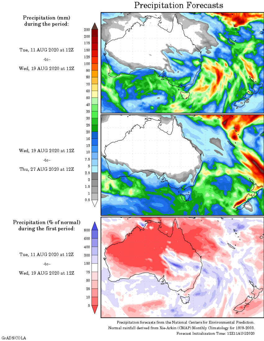
Rainfall outlook


HAVE YOUR SAY