For today’s 14-day rainfall outlook – scroll to bottom of article
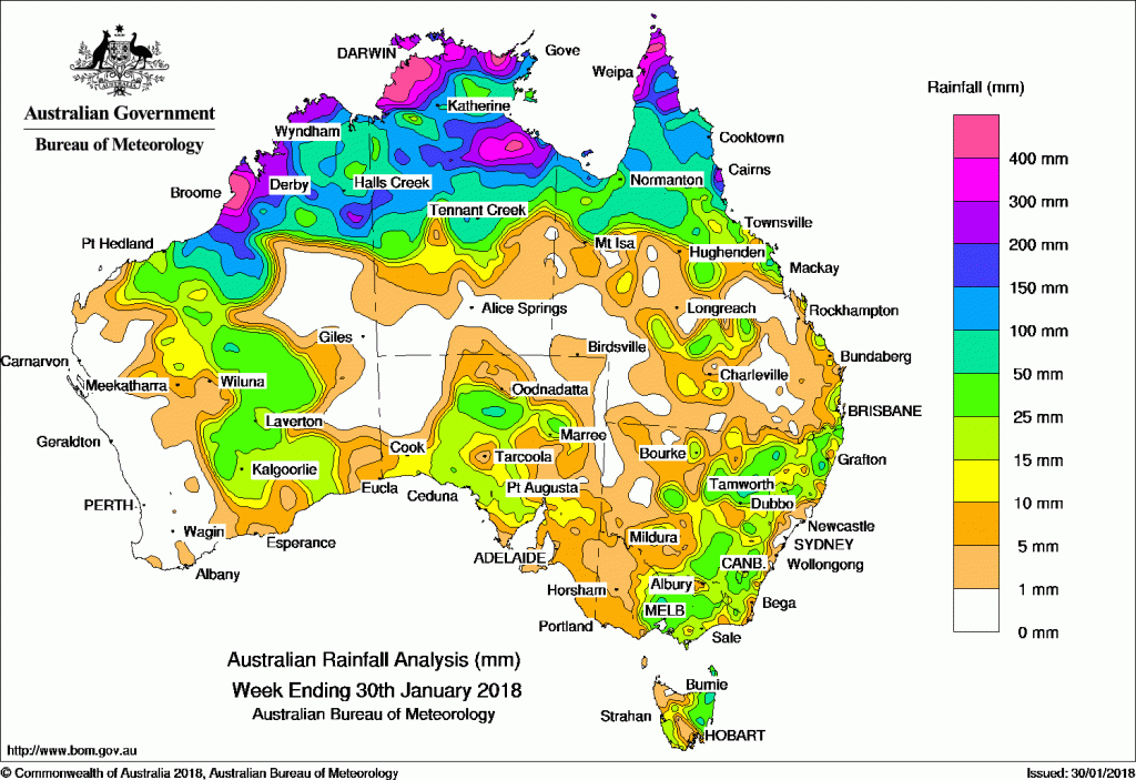
An active monsoon trough and associated tropical low produced moderate to heavy rainfall in northern Australia during the week. Surface troughs produced showers and moderate falls in parts of the west and east
The highest weekly total was 716 mm at Humpty Doo in the Darwin–Daly District of the Northern Territory.
Past seven days: Throughout the week, an active monsoon trough with embedded tropical lows across northern Australia and the Coral Sea produced extensive cloud with areas of heavy rain from embedded thunderstorms. A tropical low over the Top End of the Northern Territory in the vicinity of the monsoon trough gradually deepened as it drifted west southwest into the Kimberley of Western Australia.
The monsoon trough and the slow-moving tropical low over northern Western Australia, resulted in extensive shower and thunderstorm activity over the Kimberley, the Top End in the Northern Territory, and Cape York Peninsula for the week. Heavy falls led to flooding in parts of the Darwin – Daly in the Northern Territory, and the Kimberley in Western Australia
In the south, a patchy cloudband with thunderstorms associated with an upper level trough stretched from Western Australia, across central South Australia and New South Wales at the start of the week. Thunderstorms formed in the vicinity of a series of inland troughs parts of Western Australia and eastern New South Wales.
From the middle of the week, humid conditions combined with a broad low pressure trough and produced patchy cloud with embedded showers and thunderstorms over southern parts of the country from central Western Australia, across South Australia and over New South Wales and Victoria. A moist onshore flow brought showers and moderate falls to southeast Queensland and northern New South Wales coasts.
At the end of the week, a middle level cloudband associated with a cold front extended from western parts of Victoria and across Tasmania. Isolated embedded thunderstorms produced moderate falls in northeastern Tasmania.
Rainfall totals exceeding 400 mm were recorded in far north of the Cape York Peninsula, the Darwin-Daly District in the northwest of the Northern Territory and in the west Kimberley around Broome in Western Australia. The highest weekly total was 716 mm at Dumpty Doo in the Darwin – Daly District in the Northern Territory.
Rainfall totals exceeding 200 mm were recorded along the Kimberley coast in Western Australia, the northern Top End in the Northern Territory, parts of the Gulf Country and in far northern Queensland. Rainfall totals exceeding 100 mm were recorded north of a line from Broome in Western Australia to Cairns in Queensland.
Rainfall totals between 50 mm and 100 mm were recorded in small pockets of northeastern Tasmania, central Victoria north of Melbourne, and in eastern New South Wales.
Rainfall totals between 10 mm and 50 mm were recorded in the Pilbara, central interior and southern regions of Western Australia; parts of southern and central South Australia and eastern Victoria. Similar totals were recorded across most of the eastern half of New South Wales, northeastern Tasmania, and in pockets of central and southeastern Queensland.
Little or no rainfall was recorded along the southwest coast of Western Australia, Central Australia; also parts of the southeastern quarter of Queensland, and western and southern Tasmania.
Highest weekly totals
New South Wales and Australian Capital Territory
131 mm Lower Boro (Calderwood)
84 mm Nymboida (Sutton St)
83 mm Orange Agricultural Institute
Victoria
87 mm Romsey
80 mm Wangaratta Aero
78 mm Mollisons Ck At Pyalong, Bullengarook East, Greta West
Queensland
449 mm Weipa Eastern Ave
362 mm Aurukun Shire Council
355 mm Weipa Aero
Western Australia
715 mm West Roebuck
616 mm Broome Airport
588 mm Kilto Station
South Australia
45 mm Mount Barry Station
28 mm Marree Aero
27 mm Booleroo Centre (Willowie)
Tasmania
80 mm York Plains (Handroyd)
73 mm Flinders Island Airport
72 mm Pyengana (Forest Lodge Road)
Northern Territory
716 mm Humpty Doo Collard Road
630 mm Elizabeth Valley
605 mm The Chase
More weekly rainfall totals:
- NSW/ACT totals click here
- Vic totals click here
- Qld totals click here
- WA totals click here
- SA totals click here
- Tas totals click here
- NT totals click here
Source: BOM


HAVE YOUR SAY