For today’s 14-day rainfall outlook – scroll to bottom of article
A series of cold fronts and low pressure systems tracked across southwest Western Australia, generating moderate falls. Cold fronts also produced moderate falls in southeastern Australia.
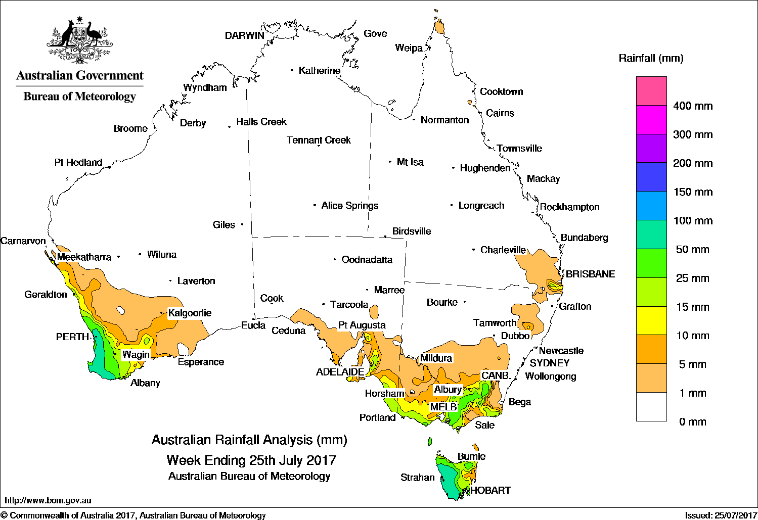
Past seven days: At the start of the week, a cold front extended over the Tasman Sea with a complex low pressure system to its west. Showers and thunderstorms produced light to moderate falls in Tasmania, most of Victoria, southeastern New South Wales and southeastern South Australia. A surface trough also produced thunderstorms and moderate falls in southeastern Queensland. In the west, a deep low pressure system and associated cold fronts approached the southwest of Western Australia, producing an extensive cloudband, with moderate falls reported in the South West Land Division in Western Australia.
From the middle of the week, a cold front emanating from the same low pressure system tracked across southwest Western Australia, generating a westerly flow and mainly light falls. Another vigorous cold front and associated cloudband followed, producing further light to moderate falls in the southwest corner of Western Australia. The cold front continued its eastward track, weakening as it reached the southeast. Widespread light falls were recorded in western Tasmania, most of Victoria and southeastern South Australia.
Rainfall totals in excess of 100 mm were recorded in an area of southwest Western Australia, including the highest weekly total of 129 mm at Worsley Downs.
Rainfall totals between 50 mm and 100 mm were recorded across most of the Lower West and Central West districts in southwest Western Australia, the western half of Tasmania, and in small pockets of the Snowy Mountains in New South Wales and the Victorian Alps.
Rainfall totals between 10 mm and 50 mm were recorded in remaining areas of the South West Land Division in Western Australia; about the Mount Lofty Ranges, Mid North and South East districts of South Australia; in southwest, central and northeastern Victoria, as well as parts of East Gippsland; most of Tasmania except the northeast, and in southeastern Queensland.
Little or no rainfall was recorded in the Northern Territory, most of Queensland except the southeast corner, New South Wales away from the Snowy Mountains area, all of South Australia except in the southeast and remaining parts of Western Australia away from the southwest.
Highest weekly totals
New South Wales and Australian Capital Territory
49 mm Cabramurra AWS
26 mm Thredbo Village, Perisher Valley AWS
Victoria
72 mm Mount Buller
60 mm Mount Baw Baw, Falls Creek (Rocky Valley)
Queensland
21 mm Maroon Dam
13 mm Oakington, Carneys Creek The Ranch
Western Australia
129 mm Worsley Downs
118 mm Mount William
109 mm Jarrahdale
South Australia
48 mm Crafers (Mt Lofty), Mount Lofty
45 mm Crafers West
Tasmania
99 mm Lake Margaret Power Station
98 mm *Mount Read
75 mm Warra
Northern Territory
0.2 mm Charles Point
*Mount Read was affected by snow and wind, and the true total is most likely higher.
More weekly rainfall totals:
- NSW/ACT totals click here
- Vic totals click here
- Qld totals click here
- WA totals click here
- SA totals click here
- Tas totals click here
- NT totals click here
Source: BOM


HAVE YOUR SAY