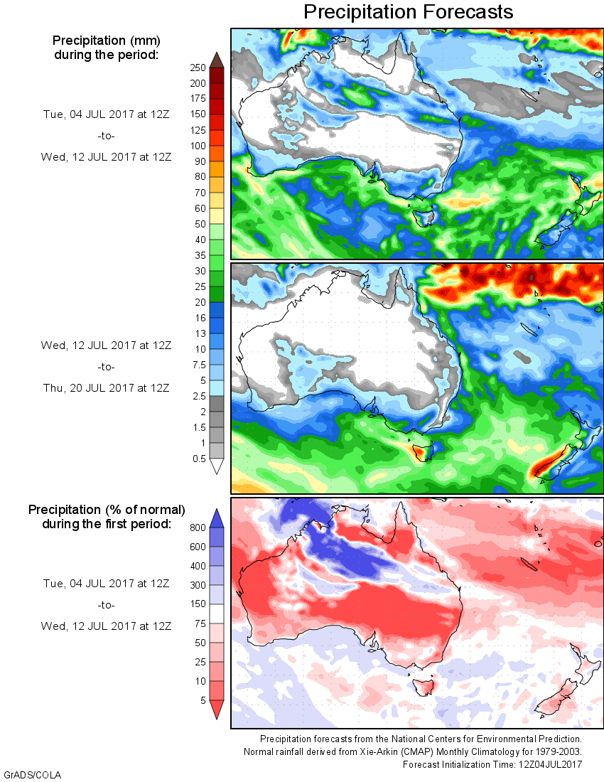
For today’s 14-day rainfall outlook – scroll to bottom of article
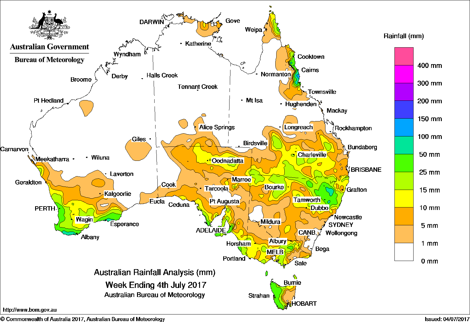
An extensive cloudband produced moderate falls in southeastern Australia and southern Queensland, while a series of rain-bearing cold fronts swept across southern Australia during the second half of the week.
Past seven days: At the start of the week, an extensive band of cloud extended from northeastern Western Australia to southern Queensland, and through South Australia, New South Wales and Victoria. Moderate falls were reported in northern pastoral districts of South Australia, in southern Queensland and northern New South Wales. A lingering surface trough located through inland Queensland and northern New South Wales produced widespread light to moderate falls in southeastern Queensland and northeastern New South Wales.
During the first half of the week, a cold front and associated cloudband tracked across Tasmania and southern Victoria. The vigorous cold front produced a cold southwesterly stream, with snow and moderate rainfall totals reported in western Tasmania. Widespread light rain fell across much of southern and eastern Victoria, and southeastern South Australia.
Moist onshore showers produced moderate falls about the north tropical coast and far north of Queensland during the middle of the week.
In the last part of the week, a low pressure system crossing the Bight drove another cold front and associated cloudband across southwest Western Australia, with thunderstorms forming behind the front. Moderate falls were reported along the west coast and across much of the South West Land Division in Western Australia. The cold front continued on an eastward track across southeastern Australia, producing light to moderate falls along the southern coasts of Western Australia and South Australia, and across Victoria and northern Tasmania. Some light falls were also recorded in inland New South Wales and southern Queensland associated
Rainfall totals in excess of 100 mm were recorded in the north tropical coast of Queensland, including the highest weekly total of 127 mm at South Johnstone.
Rainfall totals between 50 mm and 100 mm were recorded along the north tropical Queensland coast, in a pocket of northeastern New South Wales, an isolated area of northwest Tasmania, and along parts of the southern coast of Western Australia.
Rainfall totals between 10 mm and 50 mm were recorded in South West and the Southeast Coastal districts of Western Australia; northern and southern parts of South Australia; southwest, central and northeastern Victoria; and northern and western Tasmania. Similar totals were also recorded in northern New South Wales and southern Queensland, the north tropical Queensland coast and the far northern tip of Cape York Peninsula. Falls of up to 15 mm were recorded along the coast of Arnhem Land in the Northern Territory.
Little or no rainfall was recorded in remaining parts of Western Australia, the Northern Territory, central and western areas of South Australia, northwestern and most of eastern Victoria, eastern Tasmania, southwestern and southeastern New South Wales, and much of the northern half of Queensland except about the north tropical coast.
Highest weekly totals
New South Wales and Australian Capital Territory
116 mm Hunter Springs (Wondecla)
75 mm Tingha Post Office
62 mm Guyra Hospital
Victoria
35 mm Falls Creek (Rocky Valley)
33 mm Lima East (Charnwood)
29 mm Trentham (Post Office)
Queensland
127 mm South Johnstone Exp Stn
121 mm Bingil Bay
102 mm Tully Sugar Mill
Western Australia
65 mm Jarrahdale Wokalup
62 mm Telina Downs, Walpole Forestry, North Walpole
South Australia
71 mm Penneshaw
70 mm Piccadilly (Woodhouse)
Tasmania
48 mm Mount Read
47 mm Three Hummock Island
40 mm Queenstown (South Queenstown)
Northern Territory
11 mm Milingimbi Airport
9 mm Nhulunbuy
8 mm Trephina Gorge
More weekly rainfall totals:
- NSW/ACT totals click here
- Vic totals click here
- Qld totals click here
- WA totals click here
- SA totals click here
- Tas totals click here
- NT totals click here
Source: BOM


HAVE YOUR SAY