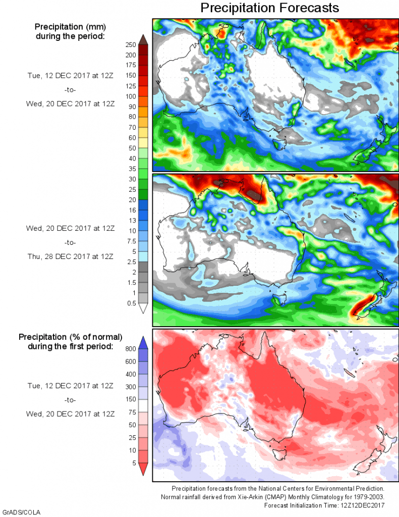
For today’s 14-day rainfall outlook – scroll to bottom of article
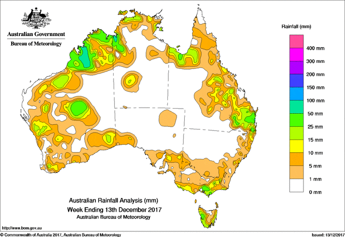
Moderate falls were recorded in southeastern Australia from the passage of a cold front, while thunderstorms and showers in southeastern Queensland and northern New South Wales brought moderate rainfall.
Moderate to locally heavy falls were recorded in the Kimberley in Western Australia, including the highest weekly total of 111 mm at Kimbolton.
Past seven days: At the beginning of the week, a surface trough extended from the Coral Sea along Australia’s east coast, with an embedded low pressure system off the coast of New South Wales. Moderate rainfall totals associated with showers and storms were recorded along the east coast and southeastern parts of New South Wales, as well as eastern Victoria. Rainfall was also recorded along the eastern coast of Tasmania as the low pressure system moved south to the east of Tasmania.
A cold front then tracked across southeastern Australia, bringing moderate falls to southeastern South Australia, southern Victoria, southern New South Wales and western Tasmania. Light falls were also recorded across much of the remaining parts of Victoria and much of eastern Tasmania.
A near stationary surface trough extended from the Gulf Country to southeast Queensland and northeast New South Wales around the same time. Thunderstorms with moderate falls formed along and east of the surface trough, with locally heavy falls reported in southeastern Queensland and northeastern New South Wales.
In the second half of the week, a deep trough formed off the west coast of Western Australia. The surface trough interacted with an upper level disturbance to produce thunderstorms and moderate falls near the west and south coasts, and central Western Australia as the system moved inland.
During the week, thunderstorms and showers developed in the vicinity of a persistent surface trough in northern Australia. Moderate to locally heavy falls were recorded in parts of the Kimberley, Pilbara and Gascoyne districts in Western Australia, and in northwestern parts of the Northern Territory, including areas of the Top End.
Small parts of the western Kimberley recorded more than 100 mm, including the highest weekly total of 111mm at Kimbolton in Western Australia.
Rainfall totals exceeding 50 mm were recorded in southeastern Queensland, and in an area of the western Kimberley and across the border into the Northern Territory.
Rainfall totals between 10 mm and 50 mm were recorded across much of the Kimberley, parts of the Pilbara, Gascoyne, central interior and much of the South West Land Division in Western Australia; in a small area of the Top End, in the northwest of the Northern Territory and in a band from the northwest to southeast of Queensland. Similar totals were recorded in eastern and southeastern parts of New South Wales; southern and eastern Victoria; southeastern South Australia; and much of western and southern Tasmania.
Little or no rainfall was recorded in remaining areas of eastern Western Australia; most of the Northern Territory away from the Top End and the northwest; much of the southwest of Queensland; western and northern New South Wales; northwestern Victoria and remaining parts of South Australia away from the southeast.
Highest weekly totals list and map
New South Wales and Australian Capital Territory
48 mm Busbys Flat
44 mm Brays Creek (Misty Mountain)
41 mm Millbank
Victoria
54 mm Mount Baw Baw
53 mm Springvale, Necropolis, Ferny Creek
Queensland
110 mm Sunshine Coast Airport
72 mm Landsborough
63 mm Barcaldine Post Office
Western Australia
111 mm Kimbolton
85 mm Windjana Gorge
81 mm Liveringa Station, Napier Downs
South Australia
15 mm Brinkworth (Bungaree),
Lake George Booborowie
Tasmania
65 mm Mount Read
33 mm Queenstown (South Queenstown), Zeehan
Northern Territory
66 mm Mccluer Island
54 mm Bullo River
52 mm Upper Wickham River
More weekly rainfall totals:
- NSW/ACT totals click here
- Vic totals click here
- Qld totals click here
- WA totals click here
- SA totals click here
- Tas totals click here
- NT totals click here
Source: BOM


HAVE YOUR SAY