For today’s 14-day rainfall outlook – scroll to bottom of article
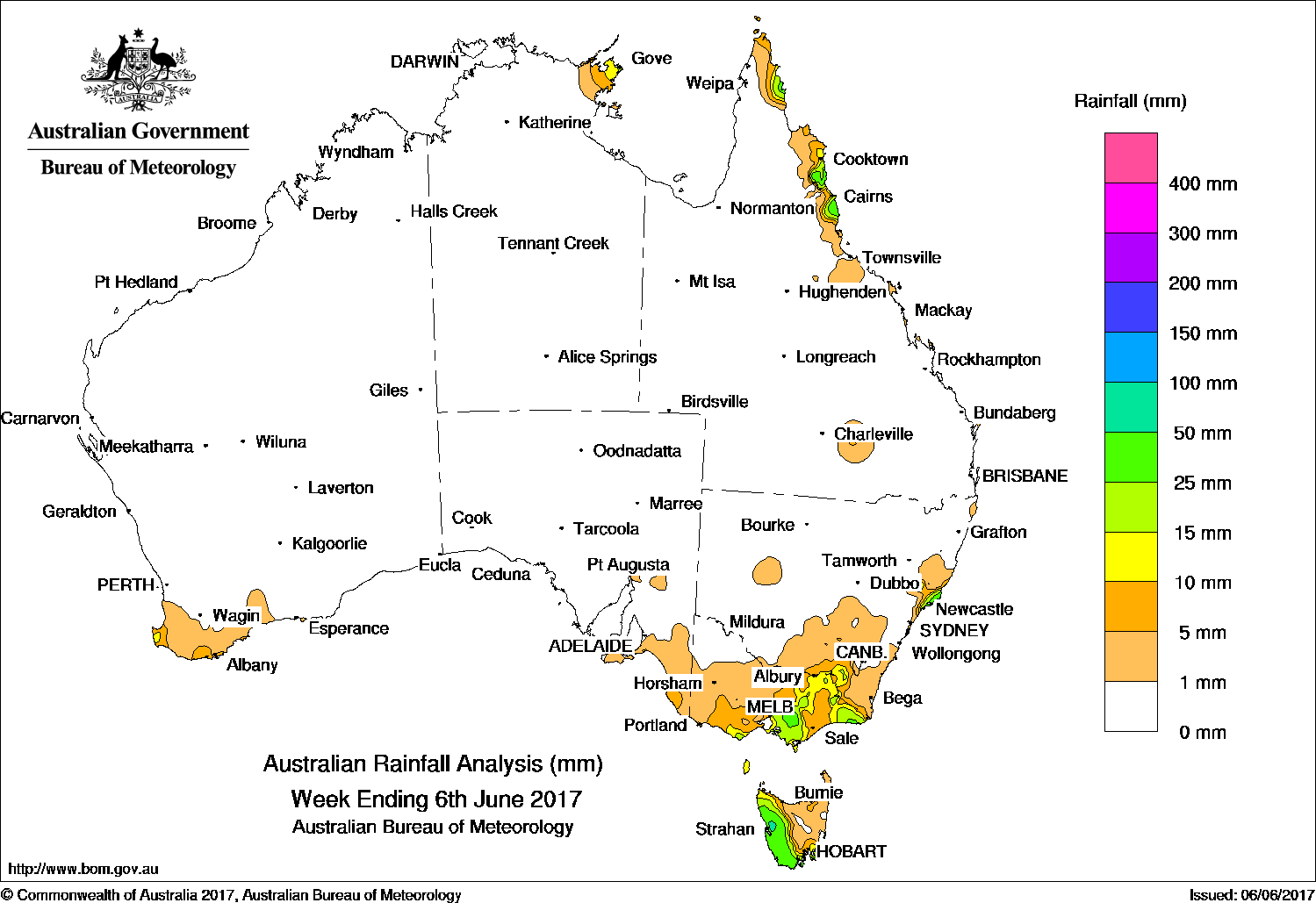
Apart from parts of Tasmania, southern Victoria and the far northern Queensland coast, most of Australia recorded little rain in the past week.
Past seven days: At the start of the week, a strong high pressure cell over the Great Australia Bight tracked slowly eastward as a cold front moved away from the central coast in New South Wales.
Apart from the southeast of the continent, where light to moderate rainfall was recorded in Victoria, adjacent southern inland New South Wales, and western Tasmania, southern Australia recorded little rain. Snow was reported on the highest slopes in the Alpine area.
In the middle of the week, a weak cold front brushed southwestern Australia with some light rainfall recorded, while a moist onshore flow brought some showers along the central coast in New South Wales.
At the end of the week, a series of fronts and troughs embedded in westerly to south-westerly flow tracked across the southeast of the country, producing light to moderate rainfall in western Tasmania, much of Victoria and southern New South Wales. Snow again fell in parts of the Alpine region.
During the week, a cloudband associated with an upper level jet stream produced isolated showers in the northeastern Top End in the Northern Territory, eastern Cape York and along the tropical north coast of Queensland.
Rainfall totals between 50 mm and 100 mm were recorded in a pocket of central coast New South Wales, on the coast of Herbert and Barron districts of the north tropical coast in Queensland, and in a pocket on the eastern coast of the Cape York Peninsula. A pocket of western Tasmania also exceeded 50 mm for the week. The highest weekly rainfall total was 129 mm at Nelson Bay in the Hunter region of New South Wales.
Rainfall totals between 10 mm and 50 mm were recorded in the Otways in Victoria; along and south of the ranges from Melbourne into New South Wales’s south west slopes but not central Gippsland; central coast New South Wales, western Tasmania, These totals were also recorded in the northern Queensland coast; the northeastern tip of the Northern Territory, and coastal pockets of southwest Western Australia.
Little or no rainfall was recorded in Western Australia away from the far southwest , South Australia, the Northern Territory except the northeast; most of Queensland away from the northeast coast, most of New South Wales away from the southeast and central coast, western and central northern Victoria and eastern Tasmania.
Highest weekly totals
New South Wales and Australian Capital Territory
129 mm Nelson Bay (Nelson Head)
92 mm Smiths Lake (Patsys Flat Road)
80 mm Careys Peak (Barrington Tops)
Victoria
45 mm Point Hicks (Lighthouse)
41 mm Mount Baw Baw
39 mm Willow Grove
Queensland
80 mm Innisfail
50 mm Daradgee
48 mm Mt Sophia
Western Australia
26 mm Greenbushes
13 mm Multiple locations
South Australia
14 mm Penola Post Office,
Goolwa Council Depot
7 mm Robe, Lucindale Post Office
Tasmania
64 mm Mount Read
49 mm Queenstown (South Queenstown)
Zeehan (West Coast Pioneers Mu)
Northern Territory
24 mm Yirrkala Tropical Gardens
18 mm Alcan Minesite
16 mm Gove Airport
More weekly rainfall totals:
- NSW/ACT totals click here
- Vic totals click here
- Qld totals click here
- WA totals click here
- SA totals click here
- Tas totals click here
- NT totals click here
El Niño development pauses
The El Niño–Southern Oscillation (ENSO) remains neutral.
The Bureau’s ENSO Outlook remains at El Niño WATCH, meaning there is around a 50% chance of El Niño developing in 2017—double the normal likelihood. However several indicators have shown little or no increase for several weeks, suggesting El Niño development has stalled for now.
Sea surface temperatures across the tropical Pacific remain warmer than average, though cooling has occurred in some areas over recent weeks in response to stronger than average trade winds. The Southern Oscillation Index has also eased to near zero values. All other ENSO indicators also remain neutral.
Four of eight international climate models suggest tropical Pacific Ocean temperatures may exceed El Niño thresholds during the second half of 2017, down from seven of eight models that were forecasting a possible event in April. Virtually all models have reduced the extent of predicted ocean warming compared to earlier in the year, indicating that if El Niño forms, it is likely to be weak.
El Niño is often, but not always, associated with a drier than average winter and spring over eastern Australia. If the tropical Pacific remains warmer than average, but El Niño thresholds are not quite met, some El Niño-like effects are still possible.
The Indian Ocean Dipole (IOD) remains neutral. Four out of six climate models suggest a positive IOD will develop by the end of winter. A positive IOD is typically associated with a drier than average winter and spring for southern and central Australia.
Source: BOM


HAVE YOUR SAY