For today’s 14-day rainfall outlook – scroll to bottom of article
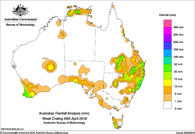
A coastal and inland surface trough produced moderate falls in southern Queensland and northeastern New South Wales. A cold front brought moderate falls to southwest Western Australia.
Past seven days: At the beginning of the week, a moist onshore flow brought showers to the east coast of Queensland and northeastern New South Wales. Showers and isolated storms were triggered along a surface trough extending from the base of the Top End, across to the Gulf Country, and through inland to southeastern Queensland. Thunderstorms developed about the Top End and produced moderate falls in the Darwin–Daly District.
In the middle of the week, the inland surface trough extended from central Queensland to central New South Wales while a surface trough developed off the coast of New South Wales. These systems produced widespread showers and storms with moderate falls recorded over inland southern Queensland, and from the northeastern to central coast New South Wales. Further showers and moderate falls were recorded over southeastern Queensland and northeastern New South Wales as the onshore showers continued for the remainder of the week.
At the end of the week, a northwesterly flow affected the southwest of Western Australia as a cold front tracked across the southern coast of the State. A cloudband extending through central and southern Western Australia produced moderate to locally heavy falls in the State’s southwest.
Rainfall totals in excess of 50 mm were recorded in the Northern Rivers District on the New South Wales coast and parts of the coast in southeastern Queensland, and isolated locations in the Darwin–Daly District in the Northern Territory, and southwest Western Australia.
Rainfall totals between 15 mm to 50 mm were observed in in South West Western Australia; across central to northern coast and inland north of New South Wales; southern inland and southeastern Queensland; and in the northern Top End of the Northern Territory.
Weekly totals of up to 10 mm were also recorded in part of southeastern New South Wales, western Tasmania, and about the coast of South Australia and the southern Gulf Coast in the Northern Territory.
Little or no rainfall was recorded in Western Australia away from the southwest, most of South Australia, Victoria and Tasmania, western and most of southern New South Wales, western and northern Queensland, and the Northern Territory excluding the northern Top End.
Highest weekly totals
New South Wales and Australian Capital Territory
136 mm Wooli Beach
132 mm Nashua (Wilsons River)
120 mm Minnie Water (Pump Shed)
Victoria
5 mm Dinner Plain, Cranbourne Botanic Gardens
4 mm Portland (Cashmore Airport)
Queensland
90 mm Peachester
67 mm Mungar Gayndah St
65 mm Point Lookout
Western Australia
60 mm Ferguson Valley
55 mm Worsley Downs
53 mm Perivale Orchard
South Australia
10 mm Nullarbor, Ceduna, Amo
9 mm Noarlunga
Tasmania
7 mm Maatsuyker Island Lighthouse
6 mm Tim Shea (Summit)
3 mm Cape Sorell
Northern Territory
75 mm Batchelor Airport
63 mm Ngukurr Airport
62 mm Alcan Minesite
More weekly rainfall totals:
- NSW/ACT totals click here
- Vic totals click here
- Qld totals click here
- WA totals click here
- SA totals click here
- Tas totals click here
- NT totals click here
Source: BOM
14 Day rainfall outlook:


HAVE YOUR SAY