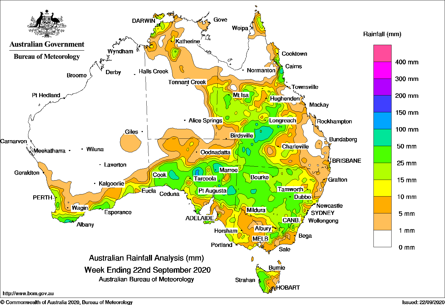
Past seven days: At the start of the week, onshore flow brought showers to the north tropical coast of Queensland. In the west and south, a pre-frontal trough and cold front moved across the south-east of Western Australia, while another cold front in the Bight approached Tasmania, bringing moderate to light falls along the Australian southern coastlines, and western Tasmania.
A low pressure system developed in far south-west South Australia as the pre-frontal trough and cold front moved slowly into western South Australia and south-western parts of the Northern Territory. Thunderstorms produced moderate falls in south-west South Australia.
During the middle part of the week, the cloudband with embedded thunderstorms, ahead of frontal systems, moved east across the southern Northern Territory and South Australia into western New South Wales and Victoria, and extended north to southern Queensland. Widespread moderate falls were recorded across large parts of the pastoral districts of South Australia including heavy falls in excess of 90 mm. Moderate falls also recorded in western Queensland and north-west New South Wales.
The low pressure system moved over south-west New South Wales and north-western Victoria, and an associated pre-frontal trough and cold front moved across eastern Australia. Thunderstorms produced further widespread falls over eastern South Australia, north-eastern Victoria, and western to central New South Wales. Storms continued over south-western, central and southern inland Queensland. In the west, a cold front moved across the south-west of Western Australia, with moderate falls reported along the state’s South Coastal and South East Coastal districts.
In the last part of the week, the cold front moved across southern South Australia and south-east Australia before another cold front approached south-east South Australia at the end of the week. A series of troughs produced areas of thunderstorms extending through the Northern Territory, Queensland and New South Wales, and widespread falls across western Queensland, eastern New South Wales, and eastern Victoria and north-west Tasmania. A westerly flow continued to produce showers in the south-west of Western Australia.
Isolated thunderstorms developed over the Top End in the Northern Territory, with falls in excess of 50 mm at some locations.
Rainfall totals of at least or exceeding 100 mm were recorded in the north tropical coast of Queensland, including the highest weekly total of 100 mm at Hawkins Creek.
Rainfall totals exceeding 50 mm were recording in the far south-west of Western Australia, small areas around the Darwin–Daly District in the Northern Territory, areas in the North West and North East Pastoral, and Flinders districts of South Australia, small pockets of western New South Wales, and in the north tropical coast and south-west Queensland. The highest weekly total of 100 mm was recorded at Hawkins Creek in Queensland’s north tropical coast.
Rainfall totals between 10 mm and 50 mm were recorded along the south-west and southern coasts of Western Australia, most of South Australia except in the north-west, in the Top End and eastern parts of the Northern Territory and most of inland Queensland and parts of the state’s north-east coast. Similar totals were recorded across most of New South Wales except in the north-east and far south-east, parts of western, southern and north-eastern Victoria, and western and northern Tasmania.
Highest weekly totals
New South Wales and Australian Capital Territory
63 mm Forbes Airport AWS
56 mm Burndoo
50 mm Oberon (Albion St)
Victoria
41 mm Mount Hotham
40 mm Falls Creek (Rocky Valley)
38 mm Mount Buller
Queensland
100 mm Hawkins Creek
72 mm Wahroongha
65 mm Isisford Post Office
Western Australia
63 mm Denmark
61 mm Denbarker
57 mm North Walpole
South Australia
99 mm Mount Eba
93 mm Marree Aero
68 mm Wilpena Pound
Tasmania
66 mm Mount Read
47 mm Lake Margaret Dam
41 mm Queenstown (South Queenstown)
Northern Territory
77 mm Darwin Airport
53 mm Nightcliff Pool
48 mm Yeuralba Ridge
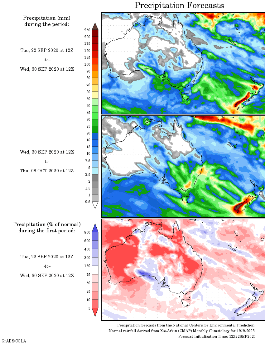
Rainfall outlook


HAVE YOUR SAY