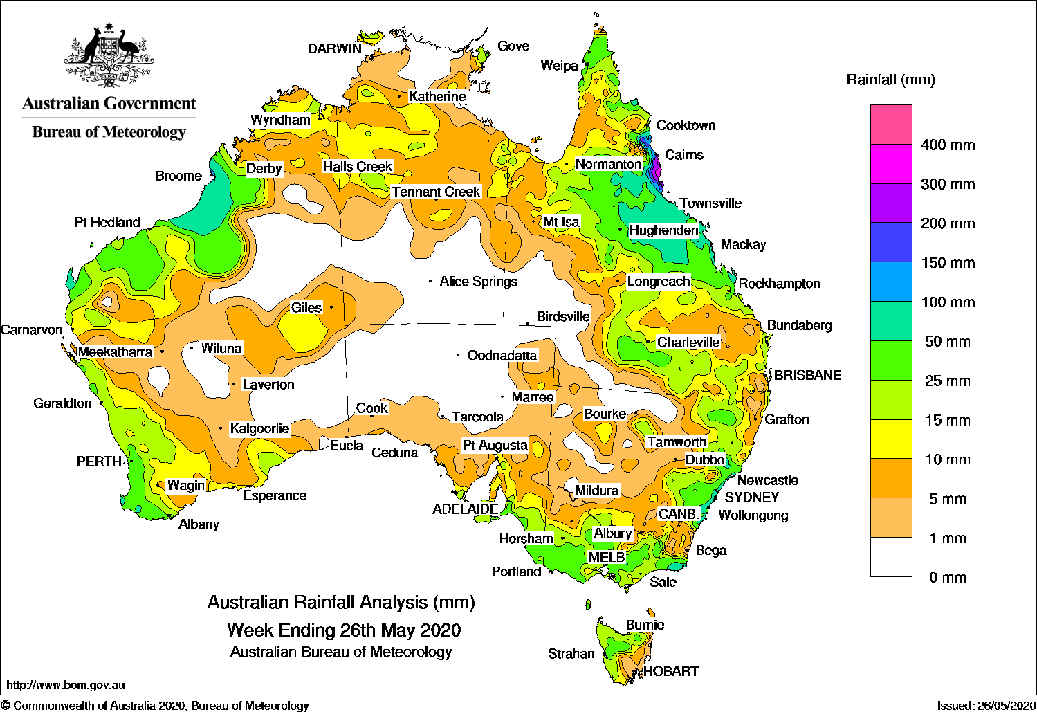
A cold front produced moderate falls in western Tasmania, while onshore flow brought showers and moderate falls to the east coast of Queensland and New South Wales.
Past seven days: At the start of the week, a high pressure system in the Tasman Sea extended a ridge along Queensland’s east coast, providing moist onshore flow onto the north tropical Queensland coast. Moderate to locally heavy falls exceeding 250 mm around Mission Beach were reported. Bingil Bay recorded 301.8 mm on the 21st, a new daily rainfall record for May at that site.
A surface trough extended from the Gulf Country, down through inland Queensland to the southeast of New South Wales and, along with another surface trough close to the east coast, produced isolated thunderstorms with widespread light to moderate falls across central, southern, and southeastern Queensland and eastern New South Wales.
During the first half of the week, a broad cloudband over northern Australia, and produced light to moderate falls across much of the Kimberley, central districts of the Northern Territory and the base of the Top End, and the Cape York Peninsula in Queensland. A broad upper trough maintained areas of rain across central to northern parts of Queensland, with widespread moderate falls across the northern half of that State during the middle of the week before the trough dissipated.
Also at the start of the week, a complex frontal system moved across southeastern Australia, with moderate falls recorded over much of Victoria, southeastern South Australia, and Tasmania. The passage of this front was associated with severe storms in parts of Victoria. By the middle of the week, this system had developed a complex low off the central and southern New South Wales coast, with further light to moderate rainfall in eastern New South Wales and northeastern Victoria. Snowfall was recorded in the Alpine regions.
Towards the end of the week, a deep low pressure system developed off the southwest coast of Western Australia as ex -tropical cyclone Mangga interacted with a strong cold front. A pre-frontal trough moved through the west Pilbara and Gascoyne, while the cold front moved through the west coast, and an associated complex low tracked the southwest and south coast. Squally and damaging winds, and moderate to locally heavy rainfall, were reported over parts of Western Australia from the west Pilbara down to the southwest.
At the end of the week, showers, thunderstorms, and squally winds continued to affect southern parts of Western Australia. The trough in the north moved east and produced moderate to locally heavy falls in the west Kimberley and Northern Interior.
Rainfall totals in excess of 200 mm were recorded around Mission Beach and Tully in the north tropical coast of Queensland, including the highest weekly total of 516 mm at Bingil Bay.
Rainfall totals in excess of 100 mm were recorded in pockets of the west Kimberley in Western Australia; small areas of the Hunter District in New South Wales; and the north tropical coast of Queensland.
Rainfall totals in excess of 50 mm were recorded the western Pilbara, and coastal areas of the Gascoyne and pockets of southwest Western Australia; from the north tropical to central coast, and adjacent inland districts of Queensland; areas in the Hunter and Illawarra districts in New South Wales; and far East Gippsland in Victoria.
Rainfall totals between 10 mm and 50 mm were recorded in the Kimberley, Pilbara, Gascoyne, Interior, South West Land Division and south coast of Western Australia; the northern half of the Northern Territory away from the northern Top End; most of Queensland except the southwest; central to eastern New South Wales; most of Victoria; southern and parts of eastern South Australia, and northern and western Tasmania.
Highest weekly totals
New South Wales and Australian Capital Territory
192 mm Careys Peak (Barrington Tops)
136 mm Barrington Tops
98 mm Robertson (The Pie Shop)
Victoria
91 mm Mallacoota
72 mm Gabo Island, Lighthouse, Cann River
Queensland
516 mm Bingil Bay
382 mm Tully Sugar Mill
303 mm Cowley Beach (Defence)
Western Australia
116 mm Mandora
110 mm Port Smith
107 mm West Roebuck
South Australia
43 mm Cape Willoughby, Piccadilly (Woodhouse)
40 mm Prospect Hill, Uraidla (Sutton Creek)
Tasmania
55 mm Mount Barrow (South Barrow)
51 mm Mount Read
48 mm Lake Margaret Dam
Northern Territory
29 mm Gove Airport
19 mm Gunn Point
18 mm Victoria River Downs
Rainfall outlook


HAVE YOUR SAY