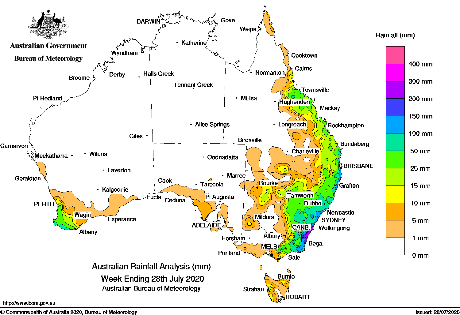
Surface- and upper-level troughs brought moderate falls to eastern Queensland, while a deep coastal low produced widespread moderate falls in central and eastern New South Wale, with heavier falls along the coast.
Past seven days: At the start of the week, a west to southwesterly air mass brought light falls to western Tasmania and southern parts of Victoria. A surface trough combined with an upper level trough over inland Queensland to produce widespread moderate falls in the state’s east from the Burdekin to Wide Bay coasts. In the west, a weak cold front and pre-frontal trough moved across southwest Western Australia, with moderate falls reported in the far southwest of that state. The frontal system moved eastwards, and produced light falls along parts of the southern coast of Western Australia and South Australia.
During the middle of the week, a trough and low pressure system developed along the southeast Queensland and northeast New South Wales coast, and brought moist southeasterly flow and light to moderate falls onto southeast Queensland and northeastern New South Wales. Another surface trough was situated over inland New South Wales, enhancing showers and rain areas, with moderate falls reported across large areas of central New South Wales.
In the last part of the week, the trough and the deepening low moved south along the New South Wales coast, and generated gusty winds and damaging surf conditions, and widespread moderate to heavy falls from the central to south coast of New South Wales and in East Gippsland in Victoria. Further moderate to locally heavier falls were recorded at the end of the week, before the system weakened and moved away from the New South Wales south coast.
Rainfall totals in excess of 200 mm were recorded in the South Coast District in New South Wales, including the highest weekly total of 351 mm at Moruya (Plumwood).
Rainfall totals in excess of 100 mm were recorded in southeast Queensland, and along parts of the northeast and central to southeast coasts of New South Wales, and East Gippsland in Victoria.
Rainfall totals in excess of 50 mm were recorded in a small area of southwest Western Australia, parts of the north tropical and southeast coasts of Queensland and along the east coast of New South Wales.
Rainfall totals between 10 mm and 50 mm were recorded in southwest Western Australia, an area of western and northern Tasmania, eastern Victoria, large areas of central to eastern New South Wales, and much of the east coast and adjacent inland districts of Queensland.
Rainfall totals of less than 10 mm were recorded in areas of the southern coasts of Western Australia and South Australia, southern Victoria, western New South Wales, and southern Queensland.
Highest weekly totals
New South Wales and Australian Capital Territory
351 mm Moruya (Plumwood)
349 mm Ulladulla AWS
348 mm Sanctuary Point
Victoria
82 mm Mallacoota
79 mm Combienbar AWS
70 mm Mount Baw Baw
Queensland
196 mm Rocky Point Sugar Mill
148 mm Springbrook Road
128 mm Gold Coast Seaway
Western Australia
81 mm Witchcliffe
75 mm Margaret River
73 mm Pemberton
South Australia
8 mm Cummins Aero
7 mm Lock, Cummins, Streaky Bay
Tasmania
30 mm Lake Margaret Dam
24 mm Lake Margaret Power Station
17 mm Mount Barrow (South Barrow)
Northern Territory
0.4 mm Centre Island, Wandie Creek
0.2 mm Gove Airport, Alice Springs Airport, Yulara Airport
Rainfall outlook


HAVE YOUR SAY