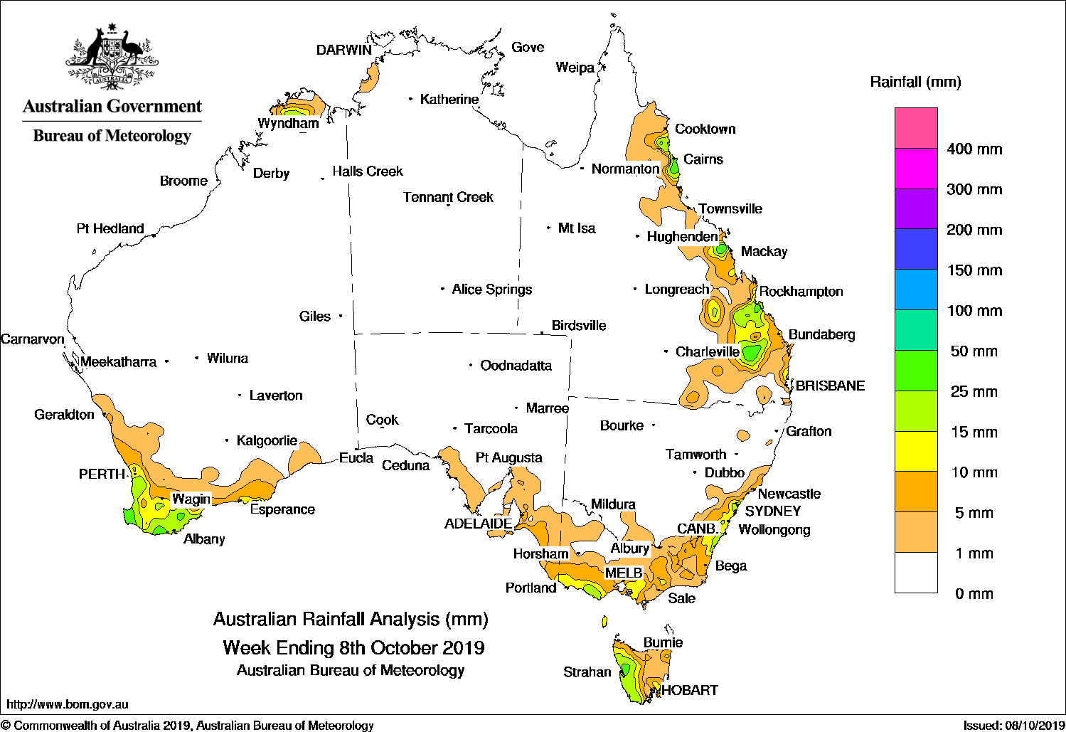
Cold fronts brought showers to coastal southern Australia, while onshore flow brought showers and storms in eastern Queensland.
Past seven days: At the start of the week a surface and upper level trough and moist onshore flow produced showers and thunderstorms over the southeast to Capricornia regions of Queensland, continuing on from locally heavy falls at the end of the previous week.
During the middle of the week, onshore flow brought showers to parts of Queensland’s North Tropical Coast.
By mid-week a developing low pressure system and an associated cold front was approaching the west coast of Western Australia, triggering light to moderate rainfall over South West Western Australia. In the east, a cold front and low pressure trough crossed the southeast bringing showers to Victoria, Tasmania, and across New South Wales from the southeast to the Hunter District. Later, the passage of a pair of cold fronts brought light showers across coastal southern Australia and Tasmania during the last days of the week.
In the north, afternoon convection brought showers to a pocket of the northern Kimberley in Western Australia towards the end of the week.
Rainfall totals in excess of 25 mm were recorded in parts of southeastern Queensland, and pockets of east coast Queensland north of Mackay and in the North Tropical Coast; in a pocket of west coast Tasmania; and in pockets of the coast of South West Western Australia. The highest weekly total was 63 mm at Mount Larcom Post Office, near Rockhampton in Queensland’s Capricornia District.
Rainfall totals between 10 mm and 25 mm were observed in parts of southeastern Queensland and pockets along the east coast near Mackay and in the North Tropical Coast District; in areas of the southern half of coastal New South Wales; in central southern and west coast Victoria; across western Tasmania; in South West Western Australia and parts of the South Coast District; and in a pocket of the northern Kimberley.
Rainfall totals up to 10 mm were also reported surrounding higher falls, and in parts of coastal southeastern South Australia.
Little or no rainfall was recorded in the vast majority of Western Australia, South Australia, the Northern Territory, Queensland away from the east coast, New South Wales away from the southeast and central coast, and in parts of northwestern Victoria.
Highest weekly totals
New South Wales and Australian Capital Territory
32 mm Mona Vale Golf Club
28 mm Wyong (Mount Elliot)
22 mm Bendalong Stp
Victoria
22 mm Terang, Ferny Creek
20 mm Jindivick
Queensland
63 mm Mount Larcom Post Office
55 mm Monogorilby – Home
45 mm Daintree Village
Western Australia
46 mm Warner Glen
40 mm Witchcliffe
36 mm Cape Naturaliste
South Australia
18 mm Ashton
16 mm Mount Lofty
14 mm Uraidla
Tasmania
47 mm Mount Read
38 mm Lake Margaret Power Station
31 mm Zeehan (West Coast Pioneers)
Northern Territory
6 mm Channel Point
3 mm Dum In Mirrie Airstrip
0.8 mm Port Keats Airport
Rainfall outlook


HAVE YOUR SAY