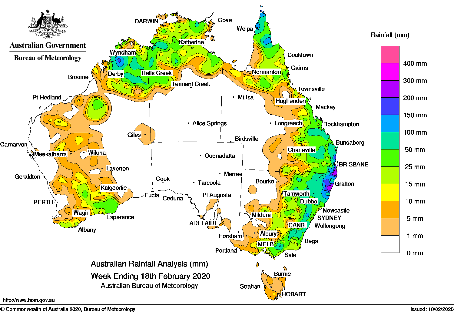
A coastal trough produced moderate to heavy falls in southeast Queensland and eastern New South Wales, while moderate rainfall was recorded in northern Australia associated with surface troughs.
Past seven days: In the first part of the week, tropical cyclone Uesi was located well off the east coast of Queensland. A trough of low pressure produced showers and thunderstorms, and extended from southern Western Australia, through the Northern Territory to Queensland. Moist, tropical east to northeasterly winds fed into a slow-moving coastal low pressure trough situated parallel to the New South Wales coast, and generated widespread cloud with rain areas and isolated thunderstorms extending from southeast Queensland down through New South Wales and Victoria.
Uesi weakened to an ex-tropical cyclone and tracked south-southwest, and was located north of Lord Howe Island. While the system did not impact the mainland directly, large and dangerous surf affected the southeast coast of Queensland and New South Wales. Showers and thunderstorms persisted over eastern Australia due to humid, easterly winds feeding into the coastal trough, with moderate to heavy falls recorded in southeast Queensland and northeastern New South Wales. A low pressure trough also extended across northern Australia, generating showers, thunderstorms and moderate falls across the Cape York Peninsula, the Top End in the Northern Territory, and through the interior of Western Australia stretching to the west coast of that State.
By the middle of the week, ex-tropical cyclone Uesi continued to track south of Lord Howe Island over the Tasman Sea. A cloudband associated with a weak trough extending through western New South Wales and central Victoria generated moderate falls in southern New South Wales and central to southern Victoria, then to eastern Victoria and from the central to southeast coast of New South Wales and the trough moved eastwards.
Showers and thunderstorms continued over northern Australia for the rest of the week due to a humid and unstable air mass, with isolated showers and thunderstorms near a surface trough through the interior of Western Australia to the Eucla region.
In the last part of the week, thunderstorms and showers developed east of a trough located through inland New South Wales, with widespread moderate falls recorded from central to eastern New South Wales and parts of southern inland Queensland. Moist onshore flow produced showers along much of the east coast of Queensland.
Rainfall totals in excess of 200 mm were recorded in southeast Queensland and in small areas of the northeast New South Wales coast, including the highest weekly total of 395 mm at Lowanna (Lowanna Road) in the North Coast District of New South Wales.
Rainfall totals in excess of 100 mm were recorded in areas of the Kimberley in Western Australia, the far north of Cape York Peninsula, far southeast Queensland, northeastern New South Wales and a small area of that State’s central coast.
Rainfall totals in excess of 50 mm were recorded across parts of the Kimberley, some areas in the Top End, the Cape York Peninsula, parts of southeast Queensland and eastern New South Wales, and northeastern Victoria.
Rainfall totals between 10 mm and 50 mm were recorded in northern and southern parts of Western Australia along with isolated areas from the Pilbara to Eucla areas, most of the Top End in the Northern Territory, northern and eastern Queensland, central to eastern New South Wales, and most of Victoria except the northwest.
Little to no rainfall was recorded in areas away from the west, north and east.
Highest weekly totals
New South Wales and Australian Capital Territory
395 mm Lowanna (Lowanna Road)
348 mm Boat Harbour (Rous River)
345 mm Murwillumbah (Bray Park)
Victoria
125 mm Mount Moornapa
70 mm Sheoaks
59 mm Briagolong
Queensland
258 mm Gold Coast Seaway
257 mm Nambour Daff – Hillside
252 mm Mt Tamborine Fern St
Western Australia
169 mm Mount Barnett
113 mm Mount Elizabeth
102 mm Nicholson
South Australia
23 mm Parawa (Second Valley Forest A
14 mm Prospect Hill, Mount Schank (Jethia)
Tasmania
19 mm Mount Barrow (South Barrow)
18 mm Burnie (Park Grove)
17 mm Kunanyi (Mount Wellington Pinn
Northern Territory
83 mm Bradshaw
58 mm Ngukurr Airport
55 mm Tindal Raaf, Birrimba
Rainfall outlook


HAVE YOUR SAY