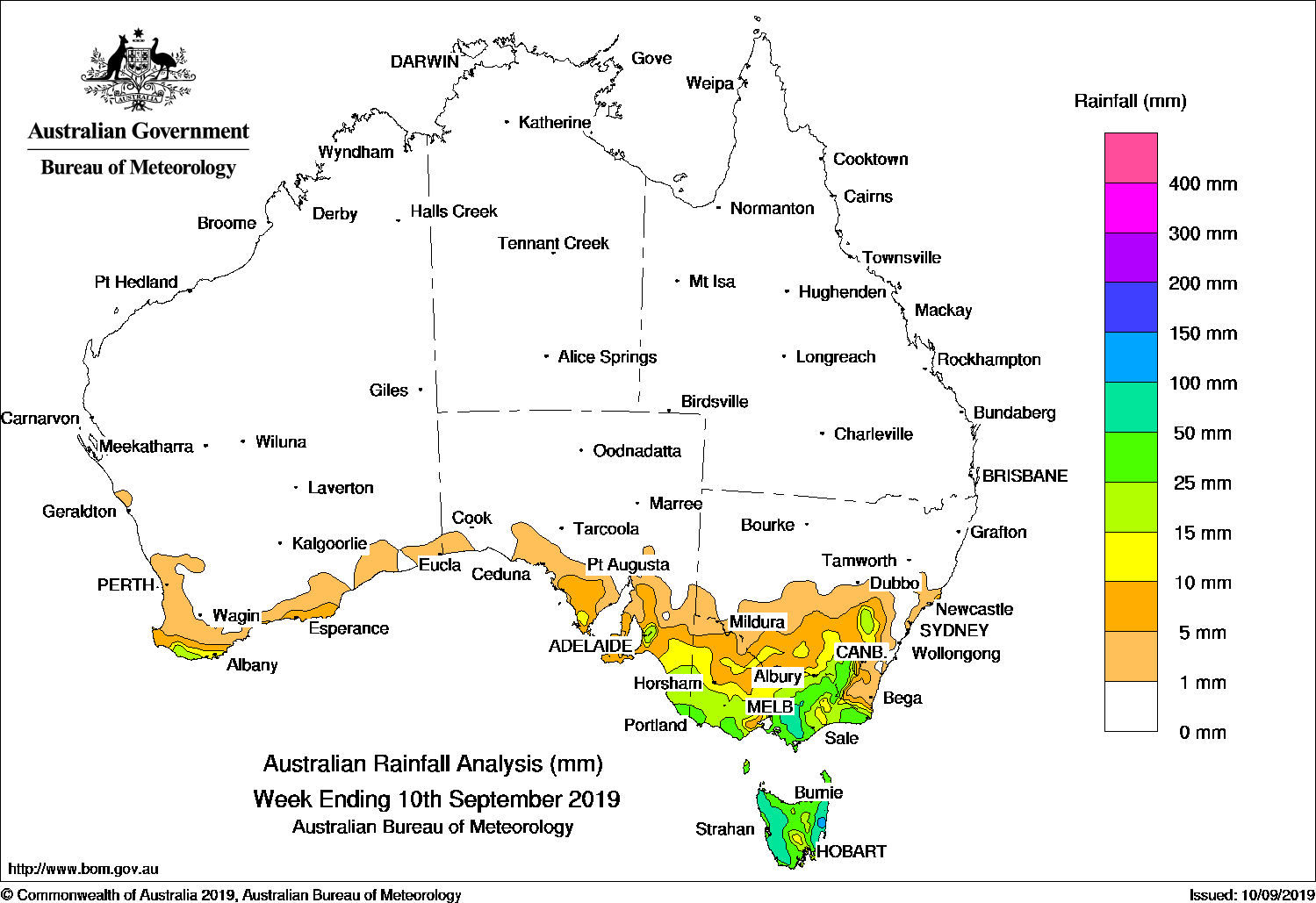
A SERIES of cold fronts embedded in westerly flow brought mostly light falls to Tasmania and southern Victoria, while showers associated with a surface and upper level trough around Alice Springs, parts of southern Queensland and northeast New South Wales, and thunderstorms brought heavy falls along the southeast Queensland coast.
Past seven days: At the start of the week an upper level trough and surface trough, and an associated cloudband, produced light to moderate falls to areas of the south of the Northern Territory and southwestern Queensland, continuing light to moderate falls produced by convective cloud at the end of last week.
By the middle of the week a low pressure centre was forming on a surface trough which extended through western and southern Queensland. The trough gradually shifted eastward, extending inland of the coast through the length of eastern Australia by the end of the week. From mid-week light falls were observed across the Maranoa and through southeastern Queensland, extending into northeastern New South Wales, and persisted in Queensland until the end of the week. On the last day of the week the trough and moist onshore flow produced showers and thunderstorms with locally heavy falls in coastal southeast Queensland.
Persistent westerly flow south of Australia, with embedded cold fronts, brought mostly light showers to western Tasmania throughout the week. Showers extended across most of Tasmania and southern Victoria during the middle of the week, and continued over western Tasmania until the end of the week. The cold fronts also brought light falls to parts of the south coast of Western Australia during the week.
Rainfall totals in excess of 25 mm were recorded in western Tasmania and in a narrow band along the coast of southeast Queensland. Storms on the last day of the week brought heavy rain to parts of coastal southeast Queensland, contributing to weekly totals in excess of 50 mm in some areas, including the highest weekly total of 136 mm at Rainbow Beach.
Rainfall totals between 10 mm and 25 mm were observed in part of the central Alice Springs District in the Northern Territory; parts of southern Queensland and surrounding higher falls on the coast of southeast Queensland; in pockets of northeastern New South Wales, coastal Victoria, northeastern Tasmania, and the south coast of far southwest western Australia.
Rainfall totals of up to 10 mm were also reported surrounding higher falls and from pockets along the south coast of mainland Australia, most of the remainder of Tasmania, areas along the central to northern coast of New South Wales, southeastern and parts of southern Queensland, and parts of Queensland’s far northern east coast.
Little or no rainfall was recorded in the vast majority Western Australia, South Australia, New South Wales away from the northern half of the coast, Queensland away from the south and southeast, the northern half of Victoria, and most of the Northern Territory.
Highest weekly totals
New South Wales and Australian Capital Territory
48 mm Dorrigo (Old Coramba Rd)
31 mm Kalang (Kooroowi (Sharabel)), North Murwillumbah (Tweed Rive
Victoria
20 mm Point Hicks (Lighthouse)
15 mm Balook
14 mm Mallacoota, Mount Baw Baw
Queensland
136 mm Rainbow Beach
105 mm Noosaville
94 mm Clontarf
Western Australia
19 mm Cheyne Beach
15 mm Manypeaks
11 mm Witchcliffe, North Walpole, Denmark
South Australia
5 mm Kingscote
4 mm Parndana Cfs Aws, Cape Willoughby
Tasmania
91 mm Mount Read
46 mm Lake Margaret Dam
44 mm Queenstown (South Queenstown)
Northern Territory
15 mm Alice Springs Airport
14 mm Territory Grape Farm
12 mm Mount Skinner
Rainfall outlook:


HAVE YOUR SAY