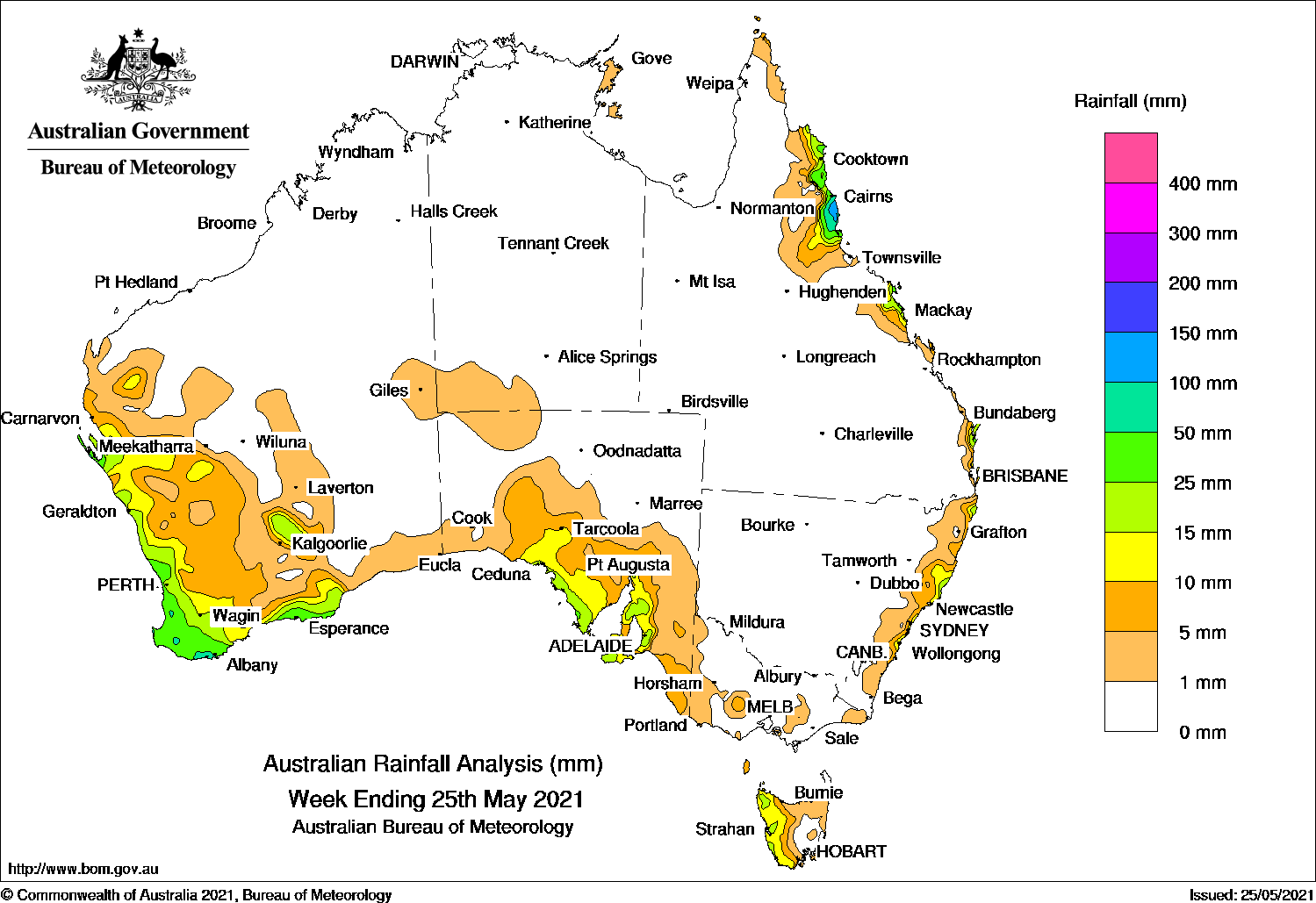
Cold fronts produced moderate rainfall in the South West Land Division of Western Australia, while agricultural districts in South Australia received widespread moderate rainfall, although totals were generally low across southeastern areas.
Past seven days: At the start of the week, a large high pressure system moved slowly across south-eastern Australia to the northern Tasman Sea, and extended a ridge along eastern Queensland and directed moist onshore winds with light showers to parts of the Queensland east coast.
In the south, a trough extended from southern Western Australia to the Australian Bight and brought isolated showers to the state’s South East Coastal District. A weak cold front moved across Tasmania and produced mostly light falls in the west of the state.
In the middle part of the week, another high pressure system tracked over south-eastern Australia to the Tasman Sea, with ridges extending to the north-east and central mainlands, bringing showers to parts of the Queensland and New South Wales coasts until the end of the week.
In the second part of the week in the west, a cold front moved across south-west and southern Western Australia, and an associated cloudband extended across the state’s north-west and south-east into the Australian Bight. Widespread moderate daily rainfall totals were recorded in the South West Land Division, with locally heavier falls of up to 50 mm recorded across much of the South West District. Moderate daily falls were also recorded in the Gascoyne and southern Goldfields districts the following day.
A strong cold front soon followed and produced further moderate falls and cold day-time temperatures in south-western parts of the state.
At the end of the week, the strong cold front connected to a low pressure system in the Bight, and moved across south-eastern Western Australia and South Australia, with the associated cloudband extending north into Central Australia. Widespread moderate daily rainfall totals between 10 mm and 30 mm were recorded in large parts of the agricultural districts in South Australia. Light falls were recorded in central and far south-eastern parts of South Australia, as well as south-western parts of the Northern Territory, and western Victoria. The west and south of Western Australian also recorded light falls, with isolated moderate falls in the South East Coastal District.
Rainfall totals in excess of 100 mm were recorded in the north tropical coast of Queensland, including the highest weekly rainfall of 159 mm at Tully Sugar Mill. Isolated falls in excess of 100 mm were also recorded in south-east Queensland.
Rainfall totals in excess of 50 mm were recorded in pockets of the South West, and the adjacent Great Southern and South Coastal districts of Western Australia, and in the north tropical coast and south-east coast of Queensland.
Rainfall totals between 10 and 50 mm were recorded in the east coast Queensland between Cairns to Rainbow Beach; small areas along the coastal north and central NSW; western Tasmania; much of the agricultural districts in South Australia except the far south-east. Much of the South West Land Division, the western Gascoyne and southern Goldfields districts in Western Australia also recorded similar rainfall totals.
Highest weekly totals
New South Wales and Australian Capital Territory
41 mm Byron Bay (Jacaranda Drive)
34 mm Old Bar (Ondarro Crest)
33 mm Bungwahl
Victoria
5 mm Merino
3 mm Patyah (Booroopki), Cape Nelson Lighthouse, Rhyll
Queensland
159 mm Tully Sugar Mill
135 mm Mt Sophia
113 mm South Johnstone Exp Stn
Western Australia
76 mm Pemberton
69 mm Cowaramup, Steep Point
South Australia
35 mm Mount Hope (Fairview)
27 mm AldgateAshton
Tasmania
30 mm Mount Read
22 mm Lake Margaret Dam
19 mm Luncheon Hill (Forestry)
Northern Territory
2 mm Gove Airport, Yulara Airport
1.2 mm Curtin Springs
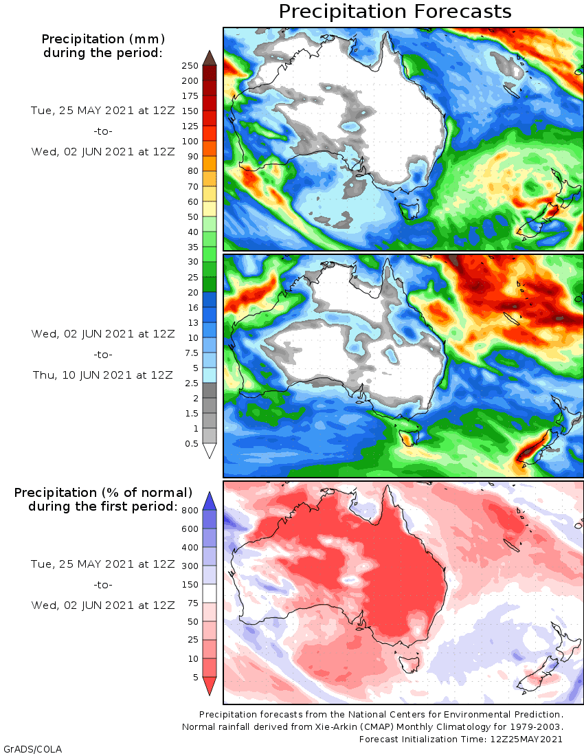
Rainfall outlook


HAVE YOUR SAY