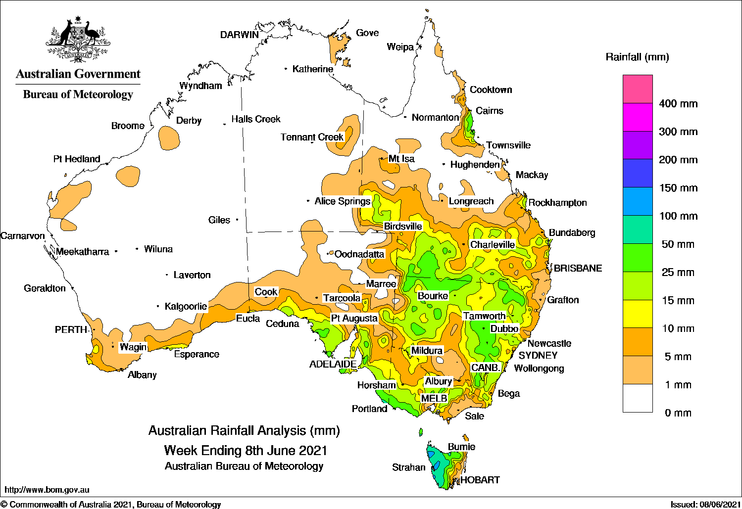
Cold fronts produced moderate rainfall in southern South Australia, south-west and central Victoria, and Tasmania, while a low pressure system and surface trough generated moderate falls in southern Queensland and New South Wales.
Past seven days: For the week to 8 June 2021, rainfall was recorded in south-west, southern, and pockets of east coast Queensland; New South Wales; Victoria; southern South Australia; small areas of the south coast of Western Australia; and most of Tasmania except the east coast.
At the start of the week, a weak low pressure system tracked over south-eastern Western Australia and a trough extended from inland northern Australia to western South Australia, bringing showers and light falls to parts of southern Western Australia and southern South Australia.
As the weak low moved across South Australia’s coast, the trough and associated cloudband tracked through eastern parts of the state. The systems interacted with an upper-level trough over western Queensland. Showers and thunderstorms produced moderate falls in south-west Queensland and north-west New South Wales.
The surface and upper-level trough moved into southern Queensland and western New South Wales, and generated widespread moderate falls over southern inland and south-west Queensland, and from central to western New South Wales. Moderate falls were also recorded over the Snowy Mountains and in central-northern Victoria.
The low pressure system and surface trough moved over eastern New South Wales by the middle of the week, and produced showers and moderate falls in parts of south-east Queensland, and eastern New South Wales, and western Tasmania.
A cold front moved across Tasmania and Victoria during the middle of the week, producing moderate falls in western Tasmania, and light falls in southern South Australia and Victoria.
In the last part of the week, a complex system of fronts and troughs connected to low pressure centres in the Southern Ocean generated moderate falls in northern Tasmania, then light to moderate falls in parts of south-east South Australia, south-west and southern Victoria, and western Tasmania as the cold front crossed the mainland south-east.
Rainfall totals in excess of 50 mm were reported in parts of western Tasmania, isolated pockets of the Central Tablelands in New South Wales, and small areas of the north tropical coast of Queensland. The highest weekly total was 117 mm at Luncheon Hill (Forestry) in western Tasmania.
Rainfall totals in excess of 25 mm were recorded in the north tropical Queensland coast, south-west Queensland and bordering areas of north-west New South Wales; also in western, central, northern inland and south-east inland parts of New South Wales, northern and south-western parts of Victoria, western Tasmania, and areas of south-east South Australia.
Rainfall totals between 10 mm and 25 mm were recorded in pockets along the southern coats of Western Australia; south-east and pockets of eastern South Australia; large parts of New South Wales except the north-east coast and southern inland areas; south-west, southern and pockets of the east coast of Queensland; and most of Victoria and Tasmania.
Highest weekly totals
New South Wales and Australian Capital Territory
51 mm Orange Airport AWS
50 mm Orange Agricultural Institute
49 mm Mudgee Airport AWS
Victoria
45 mm Cape Nelson Lighthouse
44 mm Portland (Cashmore Airport)
39 mm Grampians (Mount William)
Queensland
66 mm Hawkins Creek
47 mm Bingil Bay
37 mm Dillalah
Western Australia
19 mm Witchcliffe
18 mm The Duke
17 mm Ferguson Valley
South Australia
48 mm Ashton
46 mm Aldgate, Piccadilly (Woodhouse)
Tasmania
117 mm Luncheon Hill (Forestry)
112 mm Zeehan
111 mm Mount Read
Northern Territory
6 mm Alexandria
4 mm Gove Airport
2 mm Groote Eylandt Airport, Jervois
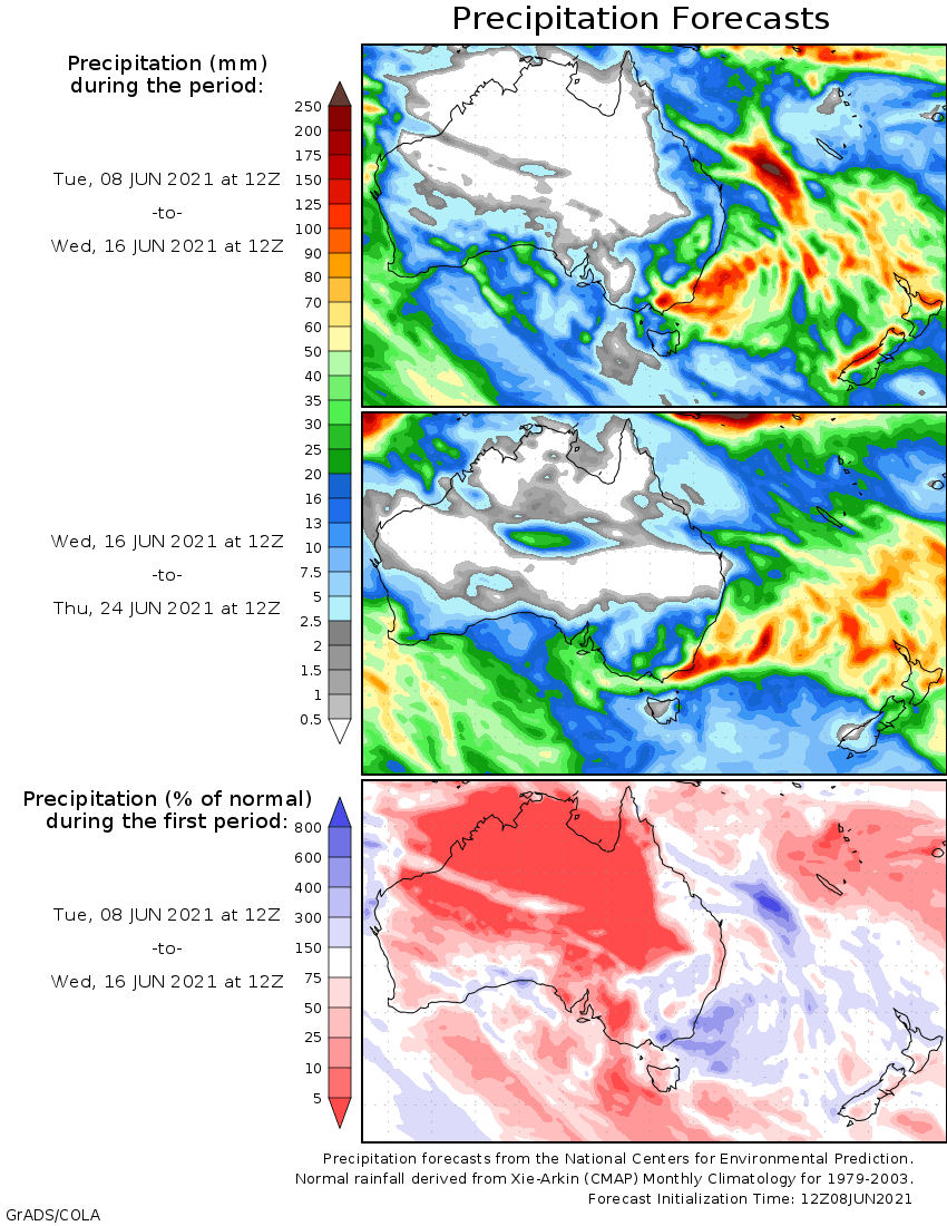
Rainfall outlook


HAVE YOUR SAY