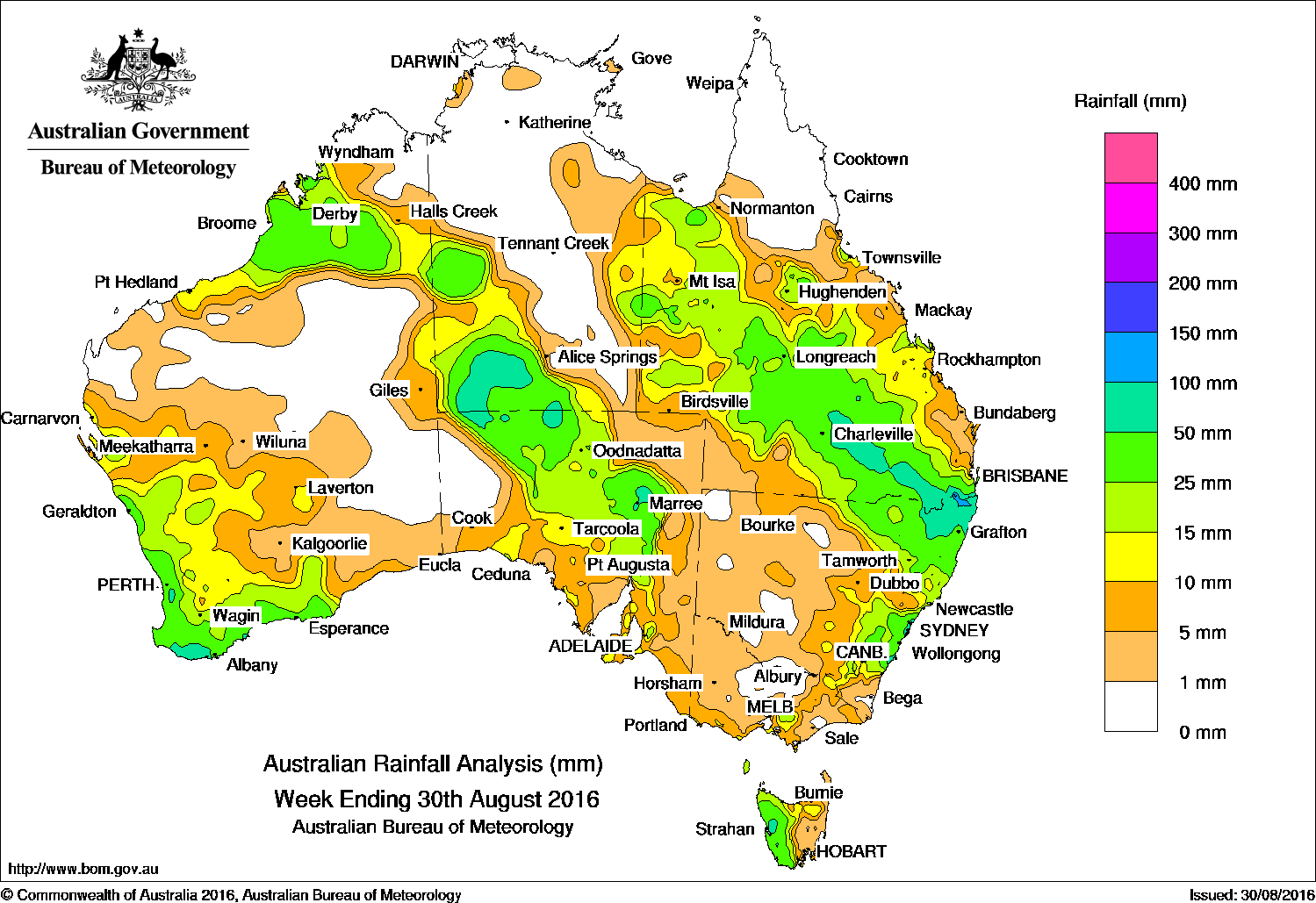
Rainfall was recorded in the northwest and southwest of Western Australia, in the east and southwest of the Northern Territory, in South Australia, southern central and northeastern Victoria, eastern New South Wales and most of Queensland except the far north.
Past seven days: At the start of the week, a broad surface trough and associated upper-level trough extended across eastern Australia, with a low developing over northeast New South Wales, generating a cloudband from western and central Queensland to New South Wales. The slow-moving surface trough and low tracked eastwards, bringing moderate to locally heavy falls over western and southern Queensland, eastern New South Wales, and in areas of central and northwestern Queensland. During the second half of the week, a deep low pressure system and associated strong cold front moved across southwest Western Australia and the Bight, while a northwest cloudband developed, extending well into central Australia. Moderate falls were reported in much of the South West Land Division and Gascoyne in Western Australia, Unseasonal moderate falls were also recorded in a broad area from the Kimberley through to the southwestern Northern Territory and pastoral areas of South Australia The system also brought moderate falls to the agricultural districts of South Australia. A second cold front tracked across the Southern Ocean, generating moderate falls in western Tasmania.
100mm plus: Eastern New South Wales and the Darling Downs in Queensland. The highest weekly total was 129 mm at Jervis Bay in the Illawarra district in New South Wales.
50mm-100mm: A pocket of coastal southwest Western Australia, areas of central Australia, parts of western Tasmania, northeastern New South Wales and parts of the southeast and southern interior in Queensland.
10mm-50mm: In the Pilbara and Kimberley and much of the South West Land Division in Western Australia; across the southwest, south and far east of the Northern Territory; along parts of the south coast and Pastoral districts of South Australia; and western and northern Tasmania. Similar totals were recorded in a pocket of central southern Victoria, eastern and northeastern New South Wales, and across most of Queensland except the far southwest and north.
Little to no rain: Northern Australia, central and southeastern parts of the Northern Territory, the central interior of Western Australia, the east and west of South Australia, most of western, northern and parts of eastern Victoria, eastern Tasmania, western and central New South Wales, and far southwest Queensland recorded little or no rainfall this week.
Highest weekly totals
New South Wales and Australian Capital Territory
129 mm Jervis Bay
126 mm Green Pigeon (Morning View)
111 mm Dairy Flat
Victoria
28 mm Ferny Creek
26 mm Main Ridge
23 mm Mount Baw Baw
Queensland
106 mm Dalveen
96 mm Carneys Creek The Ranch
83 mm Queen Mary Falls
Western Australia
68 mm Jarrahdale
67 mm Karnet
66 mm Jacup
South Australia
51 mm Marree (Farina)
47 mm Wilpena Pound
43 mm Leigh Creek Airport
Tasmania
104 mm Mount Read
46 mm Zeehan
41 mm Scotts Peak Dam
Northern Territory
41 mm Hermannsburg
35 mm Palm Valley, Watarrka
More weekly rainfall totals:
- NSW/ACT totals click here
- Vic totals click here
- Qld totals click here
- WA totals click here
- SA totals click here
- Tas totals click here
- NT totals click here
Source: BOM


HAVE YOUR SAY