JUNE rainfall was below average for most of Australia, and lowest on record for much of inland northern and north eastern Victoria, adjacent inland southern NSW, southwest and western Western Australia, and eastern Tasmania.
 Rainfall was also below average for seasonally dry areas of northern WA, the Northern Territory, and Queensland, and also below average for some areas of east coast Queensland which typically do receive rainfall during June.
According to the latest Drought Statement from the Bureau of Meteorology, the national area-averaged June rainfall was 62 per cent below the long-term mean, coming in as the second-driest June on record.
Across the country over 100 weather stations with more than 50 years of observations have reported their lowest June rainfall total on record.
The very dry June was largely due to very much higher than average mean sea level pressure (MSLP) across southern Australia, associated with a positive phase of the Southern Annular Mode (SAM).
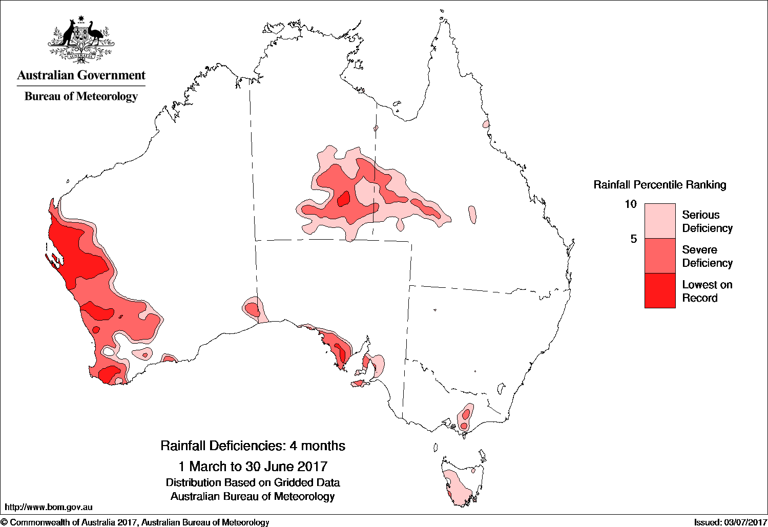
As a consequence of June’s exceptional dryness, large areas of inland NSW and Queensland are experiencing significant deficiencies at the shorter three-month timescale, which are masked at the four-month timescale due to above average rainfall during March along the eastern seaboard.
Compared to the three-month period ending May 2017, rainfall deficiencies for the four-month period have increased in both areal extent and severity along the west coast of Western Australia, with a large area around the Gascoyne coast, and smaller areas in the Central West and South West districts, observing lowest on record rainfall for similar March to June periods.
Rainfall deficiencies have also worsened on the Eyre Peninsula in South Australia, and have emerged on the Yorke and Fleurieu peninsulas, parts of the Adelaide region and the mid-North, and on Kangaroo Island; have emerged in West Gippsland and adjacent parts of north eastern Victoria; and have increased in Tasmania, now also affecting the west more broadly and the south of Tasmania.
Soil moisture is below average across the west and south of WA, most of southern SA, the southern half of the NT and far northern SA, much of inland Queensland and inland NSW, eastern Victoria, and parts of Tasmania.
Neutral outlook
Looking ahead, the tropical Pacific Ocean is currently ENSO neutral with most climate models indicating it will remain ENSO neutral for the remainder of 2017.
This means the Bureau’s ENSO Outlook is currently INACTIVE, with neither El Niño nor La Niña expected to influence Australia’s climate this year.
Although the tropical Pacific Ocean is slightly warmer than usual, this warmth is within the ENSO neutral range.
The Southern Oscillation Index (SOI) has recently been negative due to higher than normal atmospheric pressure in the Australian region, but all other ENSO indicators are at neutral levels.
In the tropical Indian Ocean, the Indian Ocean Dipole (IOD) is also neutral, with no sign of either negative or positive IOD present in the ocean or atmosphere. However, some climate models suggest a positive IOD could develop in the coming months.
Positive IOD events are typically associated with below average winter and spring rainfall over central and southern Australia.
Source: BOM
HAVE YOUR SAY