
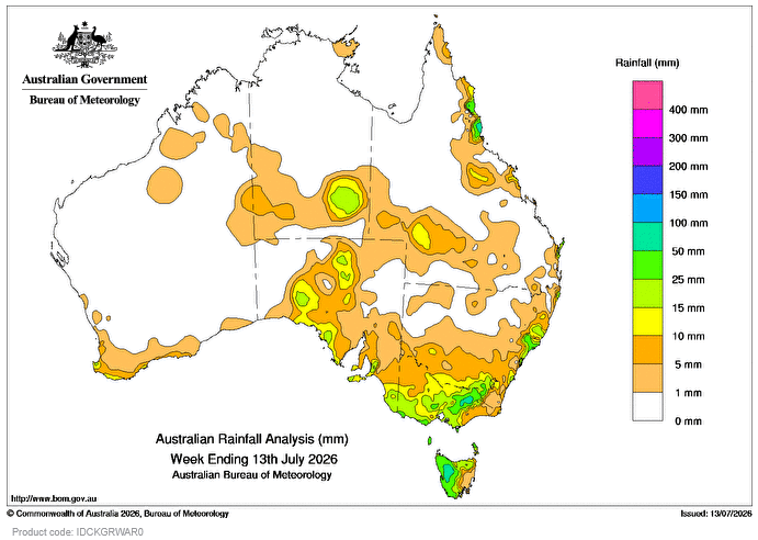
DURING the week a series of cold fronts and troughs resulted in moderate rainfall totals across south-west Western Australia, southern parts of South Australia, Tasmania, and Victoria.
Weekly rainfall totals of 5-15mm were recorded across south-west WA and large parts of the south-east, with falls of 25-50mm across elevated parts of SA and Vic, and northern and western parts of Tas.
Heavy rainfall on already saturated catchments led to flood warnings issued in north-east Vic and south-western Tas.
An upper trough produced patchy rain and isolated thunderstorms about the interior of WA and the Northern Territory before extending into SA mid-week, then moving into Queensland and weakening.
Weekly rainfall totals up to 5mm were recorded across northern parts of WA, southern parts of the NT, northern SA and south-western Qld, with totals reaching up to 25mm in some areas.
Onshore flow due to a dominant high-pressure system over Tas coupled with a deep low-pressure system near New Zealand maintained onshore showers about the east coast for several days.
Weekly rainfall totals of 5-15mm were recorded across some coastal areas of the New South Wales and Qld with isolated falls greater than 50mm in the North-Coast and Tablelands district in Qld.
The highest weekly total at a Bureau gauge of 128mm was recorded at Tully Sugar Mill in Qld.
The highest daily total at a Bureau gauge of 64mm was recorded at Mount Buller in Vic in the 24 hours to 9am on July 13.
HAVE YOUR SAY