
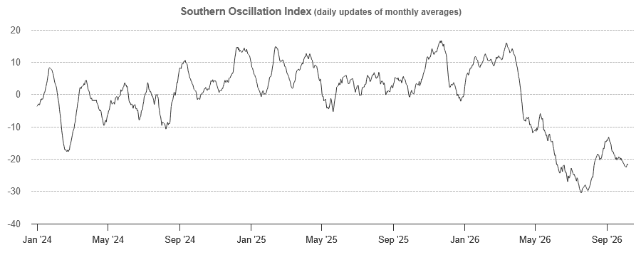
Figure 1: The Southern Oscillation Index from 1 January 2024 to 7 October 2026. Source: BoM
AUSTRALIA’S Bureau of Meteorology and the US’ National Oceanic and Atmospheric Administration have both issued recent updates on the current El Niño as it strengthens.
“Above-average rainfall is forecast for October to December in much of the western half of Australia; later in this season, this pattern extends into parts of Queensland and New South Wales,” BoM climatologist Caitlin Minney said in the BoM update posted October 1.
“In contrast, below-average rainfall is likely for parts of the far north and south-east.
“The October forecast shows a drier start to the season, with below-average rainfall likely across larger areas of northern Australia.
“Both daytime and nighttime temperatures during October to December are likely to be above average for almost all of Australia.”
Ms Minney said the current quarter holds an increased chance of unusually warm days across the southern two-thirds of Australia, especially its south-east.
“El Niño is expected to strengthen further, with the event likely to peak in late spring or summer, and a brief positive Indian Ocean Dipole event remains possible this year.”
Winter saw record warmth across Australia’s alpine regions, and much of its precipitation fell as rain rather than snow.
Partly because of this, storages across the northern Murray-Darling Basin are currently at 55 percent full, a decrease of 27pc over the past year, but storages across its south are currently at 72pc full following good winter inflows.
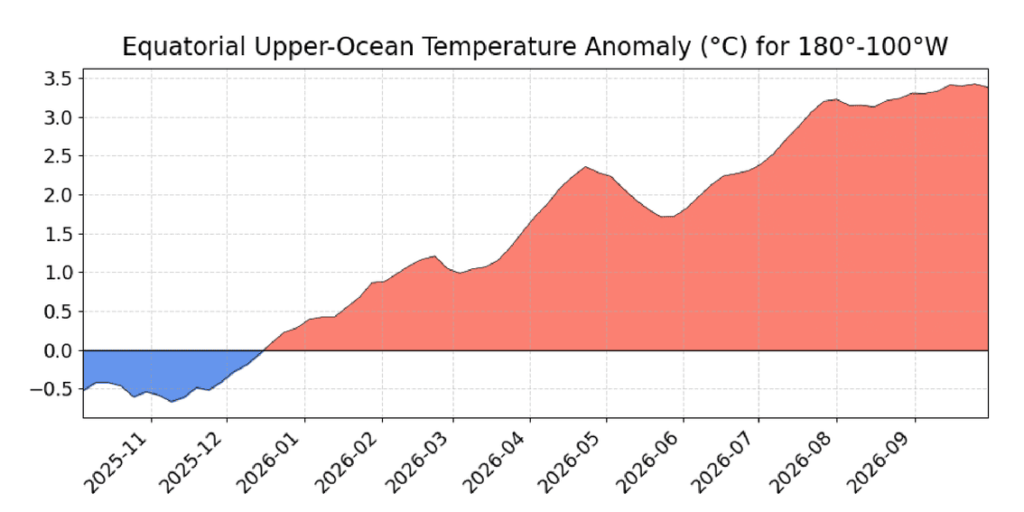
Figure 2: Area-averaged upper-ocean temperature from 0-300m in the Pacific from 5 degrees north and south of the equator, and 100-180 degrees west. The temperature anomaly is computed as the departure from the 1991-2020 base. Source: NOAA
Historic event possible: NOAA
In its El Niño-Southern Oscillation Diagnostic Discussion released overnight, NOAA said the current El Niño has continued to strengthen, with a strong-to-very strong event remaining at a greater than an 83pc chance likely through to the March 2027 quarter.
Chances remain high for a historic event that would exceed the strength of previous El Niño events dating back to 1950: the chance is 54pc for September-November, 83pc for October-December, and 70pc for November-January.
With an event of this magnitude, the chances of experiencing impacts consistent with El Niño are larger, though not guaranteed.
The discussion, issued by NOAA’s Climate Prediction Center, said the El Niño strengthened further last month, with sea-surface temperature anomalies exceeding 4 degrees Celsius in portions of the eastern equatorial Pacific.
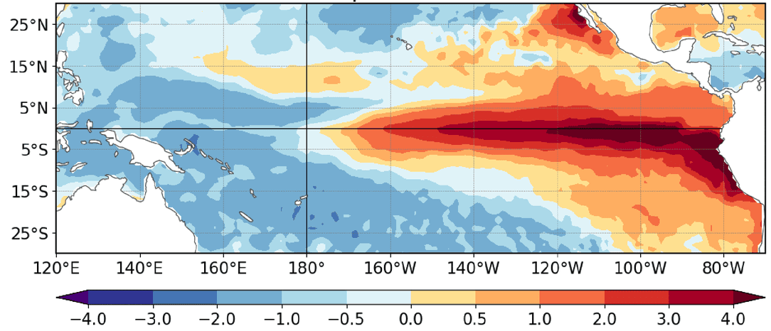
Figure 2: Average relative sea-surface temperature anomalies in degrees Celsius for September 2026. Source: NOAA
The equatorial subsurface temperature index looking at 100-180 degrees west was well above average, reflecting a deeper-than-average thermocline.
Subsurface temperatures remained above 10 degrees Celsius at depth in the eastern Pacific Ocean.
The traditional and equatorial Southern Oscillation indices were significantly negative.
Collectively, the coupled ocean-atmosphere system reflected a strengthening El Niño.
The CPC Official ENSO outlook, which synthesises multiple models from North America and abroad, indicates El Niño will continue to strengthen through the end of the year.
NOAA’s next ENSO Diagnostics Discussion is scheduled for November 12.
Source: BoM, NOAA
HAVE YOUR SAY