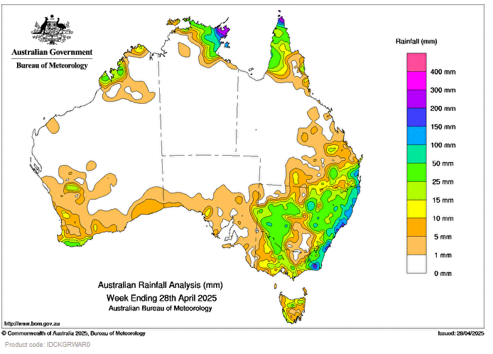
AN UPPER disturbance, low-pressure system and associated trough off the New South Wales coast resulted in showers and isolated thunderstorms for the coast and ranges, parts of eastern Victoria and south-east Queensland throughout the week.
A cold front brought scattered rain with isolated pockets of heavy falls and thunderstorms across southern Western Australia, southern regions of South Australia, Victoria and Tasmania, before moving up the New South Wales coast.
Scattered showers across inland New South Wales were driven by a low in the upper atmosphere that tracked across South Australia, western and northern New South Wales late in the week.
Weekly rainfall totals of 25 to 50 mm for parts of northern and eastern Victoria, inland New South Wales, pockets of northern Tasmania and the Western Australia south coast. Totals between 50 to 200 mm were recorded along the east coast.
Scattered showers and thunderstorms impacted northern Australia, with tropical low, 30U, strengthening the systems over the Top End early in the week.
Weekly rainfall totals of 50 to 200 mm were recorded in eastern parts of Arnhem land in the Northern Territory and northern Cape York Peninsula.
The highest weekly total (at a Bureau gauge) was 347.8 mm at Gove Airport in the Northern Territory.
The highest daily total (at a Bureau gauge) was 200.0 mm at Nambour Daff – Hillside in Queensland in the 24 hours to 9 am on 25 April.
HAVE YOUR SAY