US-BASED DroneDeploy, a cloud software platform for commercial drones, has today released its new Fieldscanner product that offers real-time drone mapping.
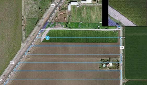 Available as part of DroneDeploy’s iOS app, Fieldscanner allows farmers to use any DJI drone to create a map of their paddocks as the drone flies so they can view insights before it lands.
DroneDeploy CEO, Mike Winn, said growers had been asking for real-time, in-field mapping for a long time, and his company was the first to deliver a solution.
He said where growers might wait days for aerial or satellite imagery, or spend hours uploading and processing a typical drone map, Fieldscanner could capture a field map in minutes.
Built for use in the field, Fieldscanner can operate entirely offline, with no need for cellular or data coverage.
It uses DroneDeploy’s existing automatic flight planning for DJI drones and adds local processing on the drone and mobile device to create a low-resolution Fieldscan as the drone is flying, instead of requiring the user to process imagery into a map at a computer after the flight.
Once the drone lands, the Fieldscan informs crop scouting and helps growers take notes in the field.
A grower can use it to spot variability in his fields, see his location as he navigates to specific areas for ground truthing, and (if a data connection is available) pin notes and photos of findings directly to the map.
If greater precision is needed, imagery captured during flight can still be uploaded to DroneDeploy to process a regular, high-resolution map and 3D model.
Source: DroneDeploy, www.dronedeploy.com
HAVE YOUR SAY