WESTERN Australia’s estimated canola area has dropped 9.2 per cent in the past month, while the forecast barley planting has risen 5.2pc to a record high, according to the Grain Industry Association of Western Australia (GIWA) June crop report released on Friday.
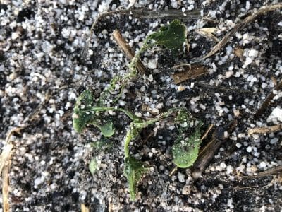
Canola seedlings battered by wind in WA’s Great Southern region north of Albany. Photo: Mark Preston
The state’s barley area is now forecast at 1.6 million hectares (Mha), with attractive prices, substitution from canola due to the lack of early rain, and resowing of wind damaged paddocks, behind the lift.
GIWA’s forecast 2018 canola area at 1.09Mha is now 300,000ha below the 2017 figure, which reflects a lack of early rains which would have encouraged growers to plant canola in time to benefit from a longer growing season, and expect better yields as a result.
At 8.24Mha, WA’s total winter crop area is down 0.2pc from the May estimate, with wheat at 4.86Mha up 0.2pc on the May figure.
Good general rains have fallen in the Geraldton, West Kwinana and West Albany port zones since GIWA released its previous crop report on 11 May, and the east Kwinana port zone has also received reasonable falls of rain enabling most crops to emerge.
GIWA reports rainfall has been light in the Lakes Region, with more rain needed in the south of WA’s grain belt over the next few weeks to get a full emergence of crops.
The rainfall in the South Albany and Esperance port zones has been very low to nil in the past month, and these areas will need good general rains soon to have any chance of returning average grain yields based on the dry winter rainfall forecast.
| Port zone | Wheat | Barley | Canola | Oats | Lupins | Pulses | State total |
| Kwinana | 2,650 | 550 | 470 | 140 | 130 | 10 | 3,950 |
| Albany | 780 | 600 | 280 | 130 | 40 | 3 | 1,833 |
| Esperance | 510 | 350 | 210 | 10 | 10 | 20 | 1,110 |
| Geraldton | 920, | 110 | 130 | 10 | 180 | 1 | 1,351 |
| Totals | 4,860 | 1,610 | 1,090 | 290 | 360 | 34 | 8,244 |
| % change from May | 0.2% | 5.2% | -9.2% | 0% | 0% | 0% | -0.2% |
Table 1: WA 2018 crop area estimates in hectares times 1000.
Source: GIWA
GIWA Oilseeds Council chair, Michael Lamond, said barley has gained canola area in recent week, particularly in regions adjacent to the south coast.
“It’s been pretty much a straight substitution out of canola,” Mr Lamond said.
“A lot of that came because of these fronts which were blowing gusts of up to 100 kilometres an hour, and bringing no rain with them.”
These fronts normally bring rain to WA’s southern cropping areas, but blocking high-pressure systems in the Great Australian Bight created intense winds.
“Canola has a more fragile seedling than cereals, and some crops in those fronts really got blasted by the wind, or buried.”
“A lot of those southern areas experienced those successive damaging winds, and most paddocks that had canola that suffered didn’t have herbicide on it might well have barley in by now.”
Mr Lamond said WA’s western cropping regions in the Geraldton and Kwinana zones were in good shape, and on track to produce average or above-average yields.
While the eastern half of the Kwinana zone got rain a week later than would have been ideal, most of its crops were also on track to yield well.
“It’s the areas around Lakes Grace and Esperance, and the eastern part of the Albany zone that aren’t doing so well.”
Rainfall outlook
The seasonal rainfall outlook from WA’s Department of Primary Industry and Regional Development’s (DPIRD) statistical model for June to August shows a preference towards below-average rainfall.
Half the international climate models observed have a neutral outlook for this period, meaning no preference towards either wetter or drier than normal conditions. About one third of models have indicated below-average seasonal rainfall is more likely.
Most of the areas in the north and eastern wheat belt of WA that delivered little or no grain last year have now had enough rain for crops to emerge.
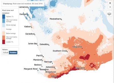
Figure 1: Modelled root-zone soil water from the Landscape Water Balance model. This uses rainfall to 6 June 2018 and shows relative soil-water storage. Root zone combines upper and lower soil depths down to 1m. Source: BoM
The Bureau of Meteorology (BoM) seasonal outlook summary for June to August indicates:
- The winter outlook issued 31 May, 2018, said the southeast mainland of Australia is likely to be drier than average.
- June has high chances of being drier than average over southeastern Australia, and is also likely to be drier across much of central and western Australia, except the southwest.
- Winter days and nights are likely to be warmer than average for most of Australia, except parts of the far north.
- Broad-scale climate drivers, such as the El Niño–Southern Oscillation and the Indian Ocean Dipole, are forecast to remain neutral during winter and thus have less influence on Australia’s climate.
- Below-average pressure over the Tasman Sea is likely to weaken the westerlies that bring rain to southern Australia.
View the full GIWA June 2018 crop report: http://www.giwa.org.au/2018
Grain Central: Get our free daily cropping news straight to your inbox – Click here
HAVE YOUR SAY