THE importance of surface water management to reduce the risk of water erosion associated with controlled traffic farming (CTF) has been highlighted, after widespread flooding across the Western Australian grainbelt due to unseasonably heavy rain last summer.
Surface water planning strategies for CTF to avoid the risk of water erosion were discussed at the recent National Controlled Traffic Farming Conference in Perth.
Farm management and design options to minimise erosion on properties that employ CTF were examined at the National Controlled Traffic Farming Conference in Perth this week.
Department of Primary Industries and Regional Development development officer, Bindi Isbister, told the conference surface water management planning was essential to prevent water flow from becoming concentrated.
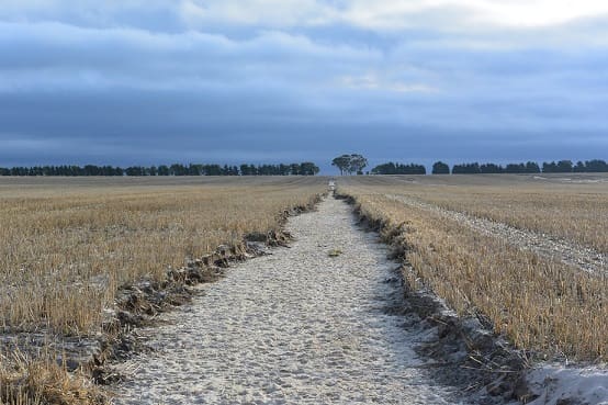
“The regular orientation of furrows and wheel tracks can act as mini drainage systems, causing concentration of water that can initiate erosion,” Ms Isbister said.
“It is important to plan machinery runlines and undertake wheel track maintenance to fill in sunken wheel tracks to minimise this risk.”
Department research has shown that paddocks sown to an up and downhill orientation enables surface water to drain uniformly down the slope, reducing the risk of furrow overflows and erosion.
Ms Isbister said other surface water management structures may be required to direct water safely, depending on the property’s soil type, landscape characteristics and paddock designs.
“The slope of the land, length of run, catchment area and soil type all contribute to the speed of the water flowing downslope and its erosive potential,” she said.
“If the slope of the land is greater than one per cent, surface water management may be required. This will also assist with reducing waterlogging or inundation in higher rainfall areas.
“Long runs that are often the most efficient for machinery operations may need to be broken up with surface water management structures. The optimum length of run and bank spacing will depend on soil type and slope gradients.”
Mitigation options include building broad based banks to allow machinery to drive over the bank and through the drain, for slopes with gradients of between two and six per cent, lowering existing banks, establishing grassed waterways or catch drains along access tracks to safely dispose of water.
Maintaining good stubble cover is another essential measure.
Ms Isbister said it was important to link up waterways between paddocks and farms, to dispose of excess water safely and reduce the severity of damage caused by flood events.
“It is also critical to prevent water shedding from uncultivated areas, such as rocky outcrops and roads, to avoid excess water concentrating in wheel tracks, which are unable to channel large volumes of water,” she said.
A range of materials are available to assist landholders to develop a surface water management plan, including aerial photographs, soil type maps and topographic data, yield maps and satellite imagery.
Some of this data can be accessed for free from the department’s website agric.wa.gov.au by searching for ‘maps and data’, while more information on CTF can be found by searching for ‘controlled traffic farming system’.
The department is continuing its CTF research, with the support of the Grains Research and Development Corporation.
The Corporation’s Western Regional Panel recently released a booklet featuring insights from WA growers about their CTF experiences, including during the flooding events last summer.
The booklet can be found at grdc.com.au by searching for the title ‘Controlled Traffic Farming – Case Studies of Growers in Western Australia.’
Source: DPIRD
Do have objective information on soil loss and runoff from controlled traffic up and down the slope versus on the contour?