WITHOUT advanced sensing technology, humans see only a small portion of the entire electromagnetic spectrum.
 Satellites see the full range–from high-energy gamma rays, to visible, infrared, and low-energy microwaves.
The images and data they collect can be used to solve complex problems.
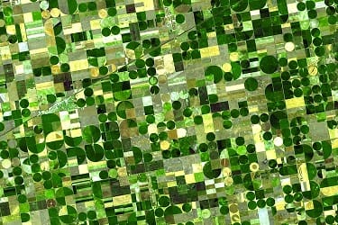
For example, satellite data is being harnessed by researchers at the University of Illinois for a more complete picture of cropland and to estimate crop yield in the United States corn belt.
“In places where we may see just the colour green in crops, electromagnetic imaging from satellites reveals much more information about what’s actually happening in the leaves of plants and even inside the canopy. How to leverage this information is the challenge,” University of Illinois environmental scientist and lead author of the research, Kaiyu Guan, said.
“Using various spectral bands and looking at them in an integrated way, reveals rich information for improving crop yield.”
Mr Guan said the work was the first time so many spectral bands, including visible, infrared, thermal, and passive and active microwave, and canopy fluorescence measurements had been brought together to look at crops.
“We used an integrated framework called Partial Least-Square Regression to analyse all of the data together. This specific approach can identify commonly shared information across the different data sets. When we pull the shared information out from each data set, what’s left is the unique information relevant to vegetation conditions and crop yield.”
The study uncovers that the many satellite data sets share common information related to crop biomass grown aboveground.
However, the researchers also discover that different satellite data can reveal environmental stresses that crops experience related to drought and heat.
Mr Guan said the challenging aspect of crop observation was that the grain, which was what crop yield was all about, grew inside the canopy, where it wasn’t visible from above.
“Visible or near-infrared bands typically used for crop monitoring are mainly sensitive to the upper canopy, but provide little information about deeper vegetation and soil conditions affecting crop water status and yield,” University of Montana collaborator and a co-author of the paper, John Kimball, said.
“Our study suggests that the microwave radar data at the Ku-band contains uniquely useful information on crop growth,” Mr Guan said.
“Besides the biomass information, it also contains additional information associated with crop water stress because of the higher microwave sensitivity to canopy water content, and microwave can also penetrate the canopy and see through part or all the canopy. We also find that thermal bands provide water and heat stress information.
“This information tells us when leaves open or close their pores to breathe and absorb carbon for growth.”
Co-author David Lobell from Stanford University, who crafted the idea with Mr Guan, said leveraging all of this satellite data together greatly increased the capacity to monitor crops and crop yield.
“This is an age of big data. How to make sense of all of the data available, to generate useful information for farmers, economists, and others who need to know the crop yield, is an important challenge,” Mr Guan said.
“This will be an important tool. And, although we started with the US corn belt, this framework can be used to analyse cropland anywhere on the planet.”
Source: University of Illinois College of Agricultural, Consumer and Environmental Sciences The study, “The shared and unique values of optical, fluorescence, thermal and microwave satellite data for estimating large-scale crop yields”, is published in Remote Sensing of Environment.
The work was initiated and designed by Kaiyu Guan from University of Illinois and David Lobell from Stanford University. It is co-authored by a multi-institute team of Jin Wu (Brookhaven National Lab), John S. Kimball (University of Montana), Martha C. Anderson (USDA ARS), Steve Frolking (University of New Hampshire), Bo Li (University of Illinois), and Christopher R. Hain (NOAA).
HAVE YOUR SAY