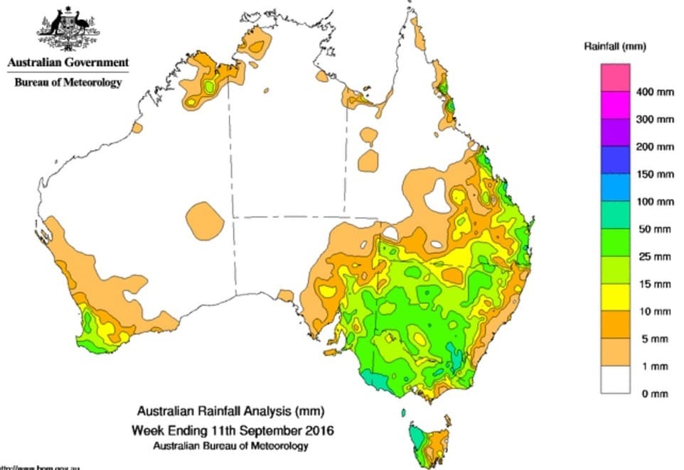
ANOTHER heavy rain front that swept across Australia’s southern and eastern farming districts late last week has come as a mixed blessing for winter crop producers.
In areas such as the Victorian Mallee where crops have been looking for moisture the rain has virtually guaranteed they will see it through to harvest.
But in parts of central and southern NSW already battered by earlier downpours, the latest falls have taken the edge of this season’s winter crop potential and, in some cases, been the last straw for waterlogged crops.
In Victoria, Flexi Grain general manager, Jarrod Tonkin, Swan Hill, said the widespread rain had been welcomed across the state’s farming regions where the winter crop was now on track for an above-average production year.
Mr Tonkin said Flexi Grain was currently estimating the Wimmera/Mallee’s cereal crop to be about 132 percent of the 10-year average.
That puts yield estimates for wheat at 2.2-4.5 metric tonnes/hectare; barley at 2.4-4.8mt/ha; and canola at 0.8-1.8mt/ha.
“The rain in the area has been beneficial,” he said. “Victoria is quite dry in comparison to NSW. The Mallee was dry with very little stored moisture prior to this and had a lot of yield potential. The further south you go, the more stored moisture there was.”
Get our free daily cropping news straight to your inbox – Click here
Mr Tonkin said the rain had almost assured that crops would now make it through to harvest.
“Canola is in full flower and barley is in grain fill now. You could have confidence the barley crop will finish and if we get the rain event forecast for this week we have confidence the wheat will finish also,” he said.
“We are expecting another 30mm of rain this week which will be well received as the Mallee had very little stored moisture before this point.”
Waterlogging
But it is a different story in parts of central and southern NSW that have been hit hardest by a series of rain events throughout the growing season.
IMAG Consulting agronomist at Forbes, Cameron Corke, said the most recent falls in the area last week had ranged from 24 millimetres up to 86mm at Bedgerabong.
“They just keep getting inundated. The impact on crops depends on soil type and where water has been laying,” he said.
“It is a real struggle at the moment. The canola pods are starting to fill but the crops are starting to fall over and we are seeing a lot of lodging. We are seeing lodging in cereals as well.”
Mr Corke said one of the key concerns was the effect the long wet was having on crop yield potential.
“The rain is definitely having an impact on yield potential,” he said.
“It may have some impact on grain quality, but not greatly yet because crops are only on the verge of flowering. It will impact on nitrogen uptake and that may have an impact on grain protein to some extent.”
Another rain front is forecast to develop across much of the south-eastern cropping region tomorrow and Wednesday.
Later in the week, rain is forecast for the cropping areas of southern Queensland.
Falls widespread
Indicative rainfall totals (mm) for the past week include:
- NSW Upper Western: Cobar 36
- NSW Central West: Parkes 41
- NSW South-West Slopes: Young 45; Wagga Wagga 49
- NSW Riverina: West Wyalong 38; Griffith 44; Hillston 52
- NSW Lower Western: Ivanhoe 41; Balranald 37
- Vic Wimmera: Donald 28; Horsham 25
- Vic Mallee: Swan Hill 19; Ouyen 18
- Tas Northern: Burnie 39; Devonport 12
- SA Lower North: Clare 25
- SA Yorke Peninsula: Kadina 15
Dams topped up
Meanwhile, the wet winter in southern regions has topped up the major irrigation reservoirs with Hume Dam on the Murray River, Burrinjuck on the Murrumbidgee, Wyangala on the Lachlan and Burrendong on the Macquarie all full to near full.
The irrigation valleys of northern NSW are still in search of more rain to replenish storages with Keepit Dam on the Namoi River at 60pc, Copeton on the Gwydir at 36pc and Pindari on the Macintyre at 75pc.

HAVE YOUR SAY