WITH HEATWAVES, dry spells and floods affecting many parts of the Australian grainbelt in recent months, gauging subsoil moisture in the lead-up to planting the 2017 winter crop is likely to be trickier than ever.

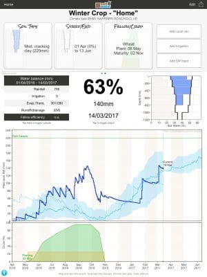
Figure 1 shows that from this month, a further 20mm gain in soil water is expected before planting at Narrabri, where a May- November winter crop will draw heavily on this stored water, and can expect in-crop rainfall of approximately 230mm.
On hand to assist is the SoilWaterApp, or SWApp, which incorporates on-farm rainfall figures and paddock specifics to give the clearest picture yet of a crop’s viability and requirements.
Developed by David Freebairn and Brett Robinson from the University of Southern Queensland and funded by the Grains Research and Development Corporation (GRDC), SWApp is a progression from CliMate and HowWet?
It was developed to provide fast and reliable estimates of plant-available-water (PAW) during fallow and crops, and requires a starting value of moisture, given as a percentage of a full profile at harvest.
“SWApp compliments measures of soil water from soil and crop sensors and weather stations. We think it is best used in conjunction with existing methods of estimating soil water and irrigation demand,” Dr Freebairn said.
In the field
To set up a paddock in SWApp, the user selects soil type, and a location to enable daily updates from Bureau of Meteorology weather data, and specifies conditions such as the type, planting date and density of crop growing, or ground cover if the paddock is fallowed.
“It seems that consultants are the greatest users of SWApp, with many having 10 paddocks, and some as many as 20.”
One of those is MCA Goondiwindi agronomist, Paul Gardoll, who uses it for clients located from Surat in southern Queensland to Moree in north west NSW.
“The rainfall’s been that patchy, so it’s a good tool to have,” he said.
Mr Gardoll said recent storms to the west of Goondiwindi at Talwood, for example, had brought 75 millimetres in 25 minutes to some growers, and nothing to others.
“I can use it to get the point across about why yields were the way they were, because it will give you a graphic to show the crop ran out of moisture, or had enough to finish well and produce good yields.
“It also provides a good discussion point when you’re talking about decisions that need to be made on things like double-cropping, fertiliser application, and yield potential.”
About SWApp
Released last February, SWApp is suitable for dryland and irrigated use, and operates on the iOS platform.
SWApp then crunches climate and rainfall data over the fallow or cropping period, and can incorporate additional data from sources like EM mapping, capacitance probes and soil coring.
SWApp does not need to be in mobile phone range as long as Bureau of Meteorology rainfall data is loaded before the latest data is sought from a site.
Graphic display
Figure 1 shows soil water at Narrabri for a dry-start winter crop last year, with 140mm of available water in mid-March, and a profile at 63 per cent full in deep cracking clay. The light blue line traces 2015 soil water, the smoother heavy blue line is the average and the dark blue line traces soil water over the 2016-17 summer.
Dr Freebairn said SWApp was not developed to be a standalone measure of plant available water.
“With experience, we are bound to find some glitches in estimates, just as we have troubles with measuring devices. Confidence builds as two opinions agree, and when they don’t, give us a good reason to double check both.”
For irrigators too
SWApp allows for three types of irrigation: Surface, sprinkler and drip.
Irrigation can be specified as:Calendar entry with dates and amounts of water applied;
- Refill deficit specified by soil-water deficit (in mm below field capacity) and a fill-point which can be to field capacity, saturation or a fixed amount;
- Time interval: regular timed applications specified by duration between applications to a specified fill-point.
Click here to find out more or download SoilWaterApp.

HAVE YOUR SAY