THE winter crop growing season in Western Australia hangs in the balance for the majority of the grainbelt.
For most growers the potential exists for at least average grain yields, and for some areas of the south coast and western regions of the grainbelt above average grain yields are predicted.
Due to the late break, together with little or no subsoil moisture at the beginning of the season, from now on crops are going to rely on regular rainfall and cooler temperatures to fulfil potential.
Prior to the rain across most of the grainbelt earlier last week, cereal crops from Esperance to the Lakes District through to north of Geraldton were starting to “sweat” off tillers on the lighter country from the lack of rain in the last month and warm temperatures.
The rain will arrest this slide in potential for the next few weeks and growers will be looking for mild conditions and rain as crops start to flower and fill grain.
The swing in total grain tonnage for WA could still be quite high as most crops currently have good potential if the predicted average or just below average rainfall for September eventuates.
On the other hand, the swing down in tonnage will be substantial if there are warm conditions with no rain in the next few weeks as the crops are just too far behind in growth stage to be able to handle a blast of hot wind.
Predictions on tonnage for the state will firm up in the next month.
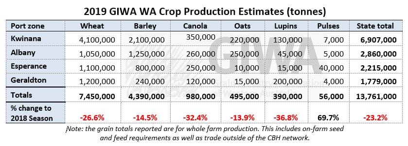
Wheat crops across the state are currently in okay to good shape and most crops could return close to average grain yields if the spring is similar to 2018.
The lower rainfall regions of the state are one of the few areas where there is some sub-soil moisture and could contribute significant tonnages if the season goes their way.
Barley is generally looking good although as you move to the northern regions, crops do not have the biomass to return high grain yields.
Canola tonnage is going to be way down on previous years simply due to the lateness of the start to the season and less area planted.
Lupin tonnage will be down from an increased area planted from 2018 for the same reasons as lower canola tonnage estimates.
Oat tonnage is on track to be somewhat similar to 2018.
Geraldton Zone
The recent rainfall in the northern agricultural zones was lighter than further south in the state and cereal crops were starting to suffer the effects of the warm temperatures with wheat and barley losing tillers and canola sheading lower leaf.
The late start to the season has had growers planning on below average or average grain yields at best and this looks like the case at the moment.
Whist even if wheat grain yields are close to average, canola, lupins and barley are likely to be well below average.
Many growers are commenting that even though the break was only 10 days later than 2018, crops look to be more than three weeks behind 2018.
The lighter country is not performing as well as the better red soils due to nutrient leaching at the start of the season and now deep “draw down” of moisture due to the below average rainfall in the last month.
Cereal crops on the lighter soils, even where ameliorated, are short and lack biomass and green colour.
The heavier red country looks better although it will also start showing the pinch if the rain drops off over the next month.
Lupin plant stand numbers are good and whilst short and late they have the ability to pod up and yield if conditions are favourable.
Lupins in the region are only just at the budding stage which is very late and most crops are getting hammered by budworm.
Some growers are commenting that budworm are early this year, although agronomists are saying they are “exactly on time, it’s the crops that are not”.
Kwinana Zone
Kwinana North Midlands
The warm temperatures and wind were the last thing crops needed and the lack of rain over the last month has started to show up with crops shedding tillers and going “off” in colour.
The rain last week has given the region a reprieve and predicted cooler temperatures this week will benefit all crops.
The lighter country has suffered more from the early leaching rains in June and lack of winter rainfall, and crops do not have the tillers or biomass to return high grain yields.
Growers in the region have reacted to the low protein in cereals in 2018 by lifting nitrogen rates this year to counter the lack of residual nitrogen from several high yielding years, the lack of good legumes and the lack of summer rain to mineralise what little organic carbon may still be in the soil.
The other factor influencing decisions this year for this region and areas of the state where wind events at the start of the 2018 season took their toll, is the amount of retained stubble and its impact on nitrogen tie up.
The low winter rainfall has meant growers have generally backed off a little on later nitrogen applications and this is now starting to show.
The difficulty around nitrogen management has been highlighted this year as the plan was to apply adequate levels, although the season has not allowed for it due to the risk of lower than average yields.
Whist the primary aim for most growers is to fertilise for maximum yield, we may again be faced with lower levels of protein than growers would like.
Following this rain there is a flurry of activity in some areas with more nitrogen being applied although for most it’s “shut the gate” on further applications thinking yields will be “average at best”.
This region is a major producer of noodle wheat and malt barley meaning that fertiliser decisions round spreading risk for segregation premiums makes it difficult to predict where tonnages in the different grades will end up.
In the eastern parts of the region where grain yields were excellent last year, the season has been drier than average to date and looks to be cutting out, prompting growers in these low rainfall areas to recall the old adage that “following a great season, have the next year off”.
Kwinana West
For most of the region, June was average to above average rainfall and for July half recent years average rainfall, with the start of August dry up until now.
This lack of winter rainfall has put a cap on the top end yields for most crops so even if the spring is wet and cool, grain yields will not reach the levels of last year.
The rainfall over the last few days has improved the outlook dramatically although crops have pushed along in the last few weeks due to the warm conditions with some cereals up to 2-3 node growth stage.
The western parts of the West Kwinana zone look good and still have at least average to above average grain yield potential for cereals.
The canola and lupins are just starting to flower and are going to need a miracle to reach average yields.
The crops are relatively clean for disease as they are for most of the state.
Spot type net blotch in barley got going early in June and due to the dry conditions since then has not progressed to damaging levels.
The recent rain will save tillers that were being shed for now although the rain is going to need to keep coming for these to fill and produce grain.
Kwinana North-East
The crops in the eastern areas of the zone are faring better than other low rainfall regions due to the summer rain that fell in March and has contributed to giving a bit of a buffer from the dry conditions.
The good heaver soils are hanging on and still could return close to average grain yields if things go well from now on.
As you move to the edges of the grain belt the recent rainfall has been less and more patchy and crops in these areas will start to run up as soon as the temperatures increase.
This region could still produce a lot of wheat if the rainfall in the second half of August and early September is around average.
There is little canola or lupins in the area, a function of the late break and whilst there is an increase in barley plantings in the region the wheat looks to have the edge over barley at the moment.
Albany Zone
Albany West
The West Albany Port zone had a later start than growers would have liked and there has been a lack of waterlogging and not receiving warm days as has been the case in the north.
Cereal crops in West Albany are still mostly tillering and have very good grain yield potential. If rainfall to the finish of the season is average, total grain yield from the zone will be above average.
A comment from one of the consultants in the region was “if more growers planted earlier, the total tonnage potentially out of the region will certainly be above average”.
There is more barley than wheat grown in the region and both are “green to the bottom”.
Leaf disease pressure has been low this year and management around leaf disease management has been very good by growers.
There has been more herbicide damage to cereal crops this year from both the pre-emergent and post-emergent herbicides due to the soft growing conditions in the region, as it has in other areas of the state.
Canola and lupin potential varies a lot with those planted early having good potential to the later planted crops well below average potential.
Albany South
The South Albany zone is in good shape and regions north and east to Esperance, where conditions have been drier to date, have received falls of up to 20 millimetres last week with those very dry areas around Ravensthorpe getting some run-off.
The zone has a mix of early sown crops from rain in April and May to the majority sown or emerging following the general rains in early June.
The early sown barley and canola crops have above average grain yield potential and this is about 30 per cent of the area.
Most crops still have good potential and if the fringes of the zone pick up more rain over the next few weeks, total grain production could be higher than average.
The early sown barley crops are at flag leaf emergence and canola 50pc flower.
Wheat is behind although this is more a reflection of planting date.
Canopy biomass for all crops is on the lower end due to the dry winter as it is for most of the state.
Grain yield potential will be above average if the grain fill period is extended.
Albany East (Lakes Region)
Prior to rain over the last few days, cereal crops were dropping tillers on the light land with the heavier soils hanging on.
Crop potential is below average and will need more than what has just fallen to change the outlook.
There is virtually no sub-soil moisture in this region and crops have been hanging on from one rain to the next.
The large area of barley in the region is clean from disease and wheat is as well.
The reduced canola area in the region will be lucky to hit 500kg/ha.
The recent rain has favoured the eastern and southern regions of the zone and this will help to push total tonnage from the region up.
Esperance Zone
The rain last week has improved the grain production outlook dramatically for the whole region.
Areas around Beaumont, Salmon Gums and Cascades received good falls and the central areas that were initially light on received some follow up rain.
The coastal strip has benefited from less waterlogging than usual and has very good potential.
The eastern areas that have struggled all year and were sitting on less than 100mm of rain since May have benefited the most with falls of more than 20mm north of Ravensthorpe.
Before the rain barley crops were starting to go off in colour on the lighter soils and some potential has been lost, although most growers in the medium to higher rainfall areas are now topping up with nitrogen with a view that it could be at least an average grain production year.
The crop biomass is generally better than northern areas of the state from the earlier start in the region and now it has had rain, the region looks to have the potential for reasonable tonnages for all crops.
As per most of the state, the variable emergence at the start of the year has carried through and the range in crop potential is quite wide.
Season Outlook
The WA Department of Primary Industries and Regional Development’s Ian Foster said rain for July was below average for most of the South West and the agricultural area.
Seasonal rain since April remains below average across much of the southern parts of the agricultural area.
Soil moisture in the root zone has been declining in the face of patchy rainfall and crop and pasture water use.
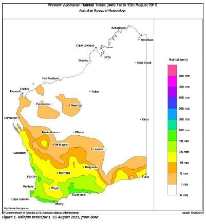
Good rainfall on August 14-15, particularly over the South Coast, is not available yet for modelling.
Instead, total rain for August to date is shown in Figure 1.
Seasonal rainfall outlooks from Australian and international models indicate August to October rainfall is more likely to be below normal for much of southern WA.
A positive Indian Ocean Dipole event is expected to continue into November.
Combined with predictions of higher than normal atmospheric pressure over Australia, this is associated with below normal rainfall over much of Australia.
Bureau of Meteorology seasonal outlook summary:
- The spring (September to November) climate outlook, issued 15 August 2019, indicates a drier than average season is likely for most of mainland Australia.
- Spring maximum temperatures are likely to be warmer than average over most of Australia.
- Spring nights are likely to be warmer across northern and western Australia. With more cloud-free days and nights expected, there remains an increased risk of spring frost in susceptible areas.
- Climate influences include a positive Indian Ocean Dipole (IOD) and an ENSO-neutral tropical Pacific Ocean.
Source: GIWA
Grain Central: Get our free cropping news straight to your inbox. Simply fill in and submit the ‘sign up’ box at the bottom right-hand corner of this page.
HAVE YOUR SAY