SEVERE frosts in Western Australia’s central grainbelt and a dry spring have conspired to shave around 700,000 tonnes off the state’s winter crop estimates in the past month.
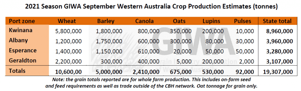
In its September crop report released today, the Grain Industry Association of WA (GIWA) is now predicting the state will produce 19.307 million tonnes (Mt) of winter crop, down from 20.027Mt forecast in August.
The revised estimates still point to a record crop, potentially eclipsing the previous highs in 2016 and 2018 of 18.158Mt and 17.913Mt respectively.
GIWA Board member and report author, Michael Lamond, said the recent frost had shifted attention away from the lack of spring rain, but the lack of useful spring rain north of the Great Eastern Highway and the lower rainfall regions was now likely to have more impact on reducing final tonnage in the state than the recent frost events.
The very cold temperatures experienced in early September will reduce deliveries by growers in the worst hit areas by at least 50 per cent on what was expected prior to the frost events.
There were also several frost events in late August over a much wider area of the state that has taken the top off crops that were at vulnerable growth stages.
As well as this, more recently there were some cold mornings that will impact grain yields for crops that were flowering in regions away from the worst hit locations.
The worst hit areas are obvious now, although the full extent of the impact from these frosts will not be evident for a few more weeks yet.
In the lower rainfall regions, the soil profile has also dried out to a point where the capacity for crops to recover from the frost will be limited.
At the same time as frost was reducing grain yield potential, the continuing dry conditions have really started to bite and crops in the northern grain growing regions, that were not impacted as much by the frost, have lost a lot of potential in the last few weeks.
The worst-case scenario has developed in the northern grain growing regions.
Here, the very high potential with a lot of top growth on the crops has contributed to sucking the profile dry and without any useful spring rain to date and warm temperatures, it is shaping up to be just an “okay” year rather than one of the best for a very long time.
On a more positive note, the Esperance Port zone has largely escaped the worst of the frost to date and the lack of hot winds have let crops continue to fill. Overall, the region is still looking at a very good year.
The same can be said for the Lakes District where the grain yield potential is above to well above average.
The south and west Albany Port zones are recovering from the waterlogging and with a mild finish, will end up with more grain than thought possible a month ago.
Total grain production can still slide from what is currently estimated if there is no further useful rain in the northern and eastern grain growing regions, and once the full extent of the frost damage is known.
Source: GIWA
Further detail on crop conditions in individual WA port zones can be found on the GIWA website.
HAVE YOUR SAY