RIVER-FLOW experts are looking to find a solution to a giant ‘sand slug’ that is adding to the problem of restricted water flows at the Barmah Choke, a narrow section of the Murray River that runs through the Barmah–Millewa Forest.
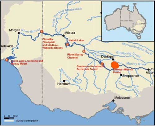
The Barmah Choke on the Murray River. (Image: MDBA)
OPINION
By Dr Ben Dyer, Director, River Management, Murray-Darling Basin Authority
SOMETHING we’re often asked at the Murray–Darling Basin Authority (MDBA) is if we’ve found a solution to the ‘sand slug’ impacting the River Murray Barmah Choke. We haven’t found a solution but we’re working with the community, seeking expert advice, and finding a way forward.
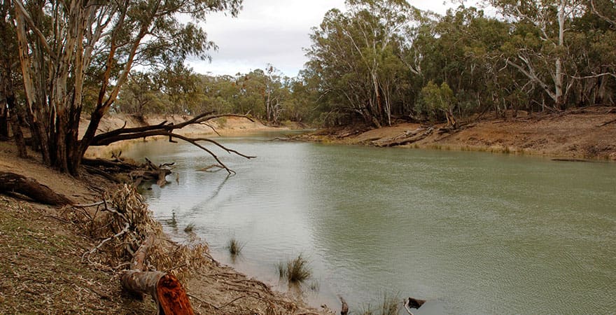
Earlier this year we shared research that revealed a surprising cause of decreasing capacity in the Barmah Choke was a massive ‘sand slug’ that experts believe has been mobilised largely by land use and mining change in the 1800s. The Barmah Choke is the narrowest part of the Murray River, that runs through the Barmah–Millewa Forest.
 Over the last year we have continued to collect and analyse data so we can better understand the ‘sand slug’, how it is moving, and the impact on the Barmah–Millewa Forest. We measured the depth of sand on the riverbed between Yarrawonga and Barmah and found that there is more than 20 million cubic metres of coarse sand in this reach – enough to fill the Melbourne Cricket Ground 13 times!
The sand is moving slowly downstream and into the reach of river where it flows through the Barmah–Millewa Forest.
The Barmah–Millewa reach is quite unusual in that water flows out of it, through creeks and flood runners, instead of into it, like most other river systems. It is a low energy reach, and the land is quite flat. The sand is coarse and heavy and even in high flows, such as a flood, the sand only moves along the bed of the river. This means that when the water flows out into the forest it leaves the sand behind, gradually filling the river channel.
The accumulation of sand in the river is significant and increases as the river flows through the forest. At the upstream end of the river about an eighth of the river is filled with sand – at the Edward Koelty offtake this increases to about a third.
The sand is accelerating erosion of the riverbanks, filling the deep pools, covering up snags and reducing the capacity of the river. If we do nothing to manage the sand this damage will continue.
This leads to the core question from communities, First Nations and industry – what can we do about this? There’s been a significant commitment from Basin governments and the MDBA to work with the locals to come up with some options.
We’re confident there’s no silver bullet solution to this problem. Instead, a multi–pronged approach looks to be the most promising option, including protecting key sections of riverbanks, removing sand in targeted areas, and moving water around the reach to reduce summer and autumn flow rates. These all need to be investigated further to determine how, when and where each of these options could be applied. Finding solutions to address the sand slug is part of our broader work program to address potential shortfall and capacity issues including through the Barmah Choke feasibility study.
Community consultation has been a key part of our work. We’ve spent considerable time this year talking with First Nations, irrigators, local government, state water authorities, National Parks representatives and environmental agencies about the problem and the possible solutions. These conversations won’t stop, and we’ll continue to engage with the people who, like us, are fighting to preserve this amazing stretch of river.
Later this year we’ll submit findings and options to the Basin governments through the Basin Officials Committee (BOC) and recommend that we progress to an options-development stage. If this is supported, the work will take about a year to complete and will be presented back to BOC.
A century-old problem can’t be reversed overnight, but we’re confident this work will help maintain the longevity of the River Murray and the magnificent Barmah–Millewa Forest and we will continue to bring the local community on the journey to find workable solutions.
…………………..
Background:
The Barmah Choke is a narrow section of the Murray River that runs through the Barmah–Millewa Forest. The Choke restricts the flow of the Murray River to around 7,000 megalitres (ML) per day.
About 25,000 years ago, an uplift of land created a north-south geological fault in the earth’s surface near Deniliquin (New South Wales) and Echuca (Victoria).
This natural event changed the River Murray forever, creating what is known as the Barmah Choke—a narrow section of the River Murray that runs through the Barmah–Millewa Forest.
While it is generally referred to as the Barmah Choke, it is actually made up of three key flow constriction points: the Tocumwal Choke, the Barmah Choke and the Edward Choke.
In fact, the forest formed as a result of regular flooding in this section of the river. Because the river is so narrow, flows would often spill over onto the floodplain.
The Choke restricts the flow of the River Murray to just around 7,000 megalitres (ML) per day, estimated at Picnic Point. This is the lowest flow in any stretch of the Murray.
It presents a challenge for river management, primarily because it limits the delivery of irrigation water during periods of peak demand, generally in spring and summer.
During summer and autumn, river managers aim to keep flows at or below channel capacity to minimise unseasonal flooding of the Barmah–Millewa Forest.
This constraint provides challenges in meeting downstream peak water use demands and transferring water to Lake Victoria and South Australia, for storage in use even in relatively dry years.
The Choke has led to a restriction in water trade from areas upstream to downstream of the Barmah Choke, which must be considered in business planning.
Source: MDBA
To find out more about the Barmah Choke, visit the website: The Barmah Choke | Murray–Darling Basin Authority

I operate a sand quarry adjacent to the Barmah Forest and have a lot of experience in the sand industry and would like to be involved in the discussions around the possible ways of removing the offending sand.
I also believe Tullah or Smith’s Creek used to be a permanent stream and was blocked off by the logging industry using bullock teams to haul out logs. They constructed a corduroy crossing through the creek adjacent to the river and that has restricted flows and the creek now only flows when the river reaches approximately 14000ML. I believe this creek has the capacity if reinstated to the natural level to carry between 1 and 2 thousand megalitres a day past the choke.
It is interesting that Peter Newman mentions Tullah or Smiths creek. I recall Bunna Walsh’s canal mentioned in the early days. I would like to hear other locals tell their story.
Thanks for your helpful comments and historical observations Howard Jones and Peter Newman, -Eds.