HOPES of an average season for Western Australian grain growers following rain in late August have been dashed with continuing warm dry conditions in the northern half of the state and recent frost events in the southern half.
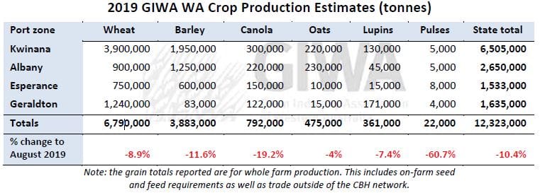
It is unclear exactly how much potential grain yield has been lost in the last two weeks, although it is unlikely WA grain production will exceed 12.5 million tonnes (Mt) for all crops, according to the latest crop report from the Grain Industry Association of WA (GIWA).
GIWA Oilseeds Council chair and crop report author, Michael Lamond, said crops had been looking okay, but were now going backwards after the last two weeks of warm conditions and no rain.
“They are still above average in the western areas in a line from Moora down to Meckering, Narrogin and west of the Albany Highway. There are even patches east of that that aren’t bad. But, big chunks of the north and eastern areas are really starting to fade away,” he said.
Rainfall near the end of August could have pushed production for the state past the 15Mt mark if growing conditions in September were about average.
The WA Department of Primary Industries and Regional Development (DPIRD) climate specialists had been predicting a warmer and slightly drier September since June and the first half of the month has followed this trend.
Growers away from the southern regions were always factoring in the risk of below average grain yields from the late break and little subsoil moisture.
The disappointing aspect is the cereal crops in general still looked like they could produce close to average grain yields as little as two weeks ago.
Crops in the southern regions were further advanced than the north as many had germinated prior to the general break to the season in the first week of June.
Unfortunately, this contributed to the wide scale damage from the frost events near the end of the first week in September.
Crops generally had more top on them and were running the moisture profile down when the very severe frosts occurred.
The frost events were then followed by a blast of heat.
The worst possible combination of susceptible growth stage; very cold temperatures for extended periods during the night, followed by extreme heat resulting in unprecedented crop loss for some growers and a significant reduction in tonnage for most in the worst affected regions.
Whilst total grain production has been downgraded, the greatest effect on individual crop production will be for canola, lupins and pulses.
“Canola in the north didn’t get the length of growing season it needed. It only started flowering into August/early September. Lupins have been the same. They just didn’t have time to yield,” Mr Lamond said.
“Most of the pulses are in the southern areas and were hit with frost.”
All crops have been badly affected in the worst frost impacted areas, although, as you move north where cereals have been less affected from frost, the canola and pulses particularly have had the top taken off their potential yield as they were in the middle of flowering.
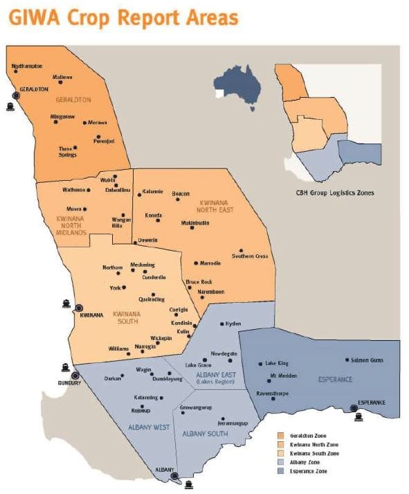
Geraldton Zone
The finish in the Geraldton port zone was always going to be critical for crops due to the late start and lack of subsoil moisture.
Crops last year finished well with a similar growing season rainfall to date and mild temperatures in the spring.
The difference this year is the crops were a week or two later getting started and had little moisture underneath from summer rain.
Whist crops are short and lack the biomass of last year, the head size is good so there was potential for the cereals to reach close to average grain yields.
This will not eventuate now as the heat has come on and with no rain in the last two weeks adding to very light falls at the end of August, crops are transpiring themselves to expiry.
The good quality heavier soils have looked better than the lighter country all year, although, with the lack of rain are now going backwards very quickly.
For the cereals, the barley has been more affected than the wheat from the hostile finish as was expected.
Canola production in the region is going to be well down as most were just starting to set pods when the heat came on.
The lupins are also going to be low yielding with some growers commenting that they will need a vacuum cleaner to pick them up.
The stark difference between the ameliorated and non-ameliorated country is not as obvious as was in the last few years simply because there is just not the moisture in the profile for crops to access.
Kwinana Zone
Kwinana North Midlands
The Midlands region is holding up a little better than further north as the rainfall events in late August were slightly higher.
In the eastern parts cereal crops are now dropping tillers and the leaves curling up from lack of moisture.
The difference in soil types is really starting to show up as well with the deeper medium soils not going off as quickly as the lighter and very heavy soils as you would expect with this sort of a finish.
In the central and western regions, the crops are better, and particularly in the line north and south through Moora are sitting on at least average grain yield potential.
Further east the cereals were flowering during those very hot days last week and many growers fear the worst from reduced grain fill sites in cereal heads from heat shock where crops were not able to pump enough moisture to keep cool.
Kwinana South
The Kwinana South zone is still in good shape considering the warm temperatures and lack of rain recently.
This region received a little more rain during each event through the year and this is now starting to show up with the crops hanging on better than most other regions in the state.
All crops still have above average grain yield potential, and for canola, it is one of the few regions where grain yield potential is holding up.
The cereal crops do not have the top end yield potential of previous years and are looking more like above average rather than well above average.
Wheat and barley are late although they have had a pretty good run.
There was little waterlogging during winter, not much leaf disease and clean for weeds.
Most crops in the region will still be able to benefit from the predicted cooler temperatures on the way.
Kwinana North East
The large grain growing regions in the East and North Kwinana have been going backwards in the last two weeks from the warm days and lack of rain.
This region has had more stored moisture throughout the year than other regions although you can see the effects of moisture stress starting to kick in now.
Cereal crops will mostly be below average in the area.
The difference in the better soils and where there was more subsoil moisture from storms in the summer is showing up now and will mean the difference between average and below average grain yields.
The cereals on fallow and wider row spacings are holding up well on the better soils and are likely to make close to average grain yields.
Grain protein for wheat in the region is expected to return to historical higher levels from crops flowering later than they have for many years and the lack of moisture forcing them to finish quickly.
Albany Zone
Albany West
The western areas of the zone are still looking good as it has all year.
The region seems to have escaped most of the frost that has affected crops further south and east, and cereal crops are now into grain fill with average to above average grain yields likely, especially for the earlier sown crops.
Most crops are clean for disease and weeds and did not have the usual waterlogging in the winter.
There is still some potential for a lift in grain yields as the region has not suffered through as many hot days as further north and will still benefit from any rainfall events in the next few weeks.
These western higher rainfall zones of the state are going to carry the load in grain production this year and are the only areas where crops can exceed average grain yields.
Albany South
The cereals and canola have been hit hard from the frost events in the first week of September and the differences in eventual grain yield is going to be massive as some of the better looking earlier maturing crops have been the hardest hit.
Crops have been damaged further south and west than is usual and as per the Esperance zones, the damage has travelled into non-traditional “frosty areas”.
All crops at susceptible growth stages have been affected by the frosts and due to the differences in emergence dates there is going to be a wide range in eventual grain production between paddocks.
Albany East (Lakes Region)
Crops in the region are still going to have below average grain yield potential for most areas as has been the case all year.
The late start and cold conditions at germination mean crops are very late and with the season finishing in a hurry, there is not much upside for all crops.
Growers in the region have been managing for average to below average grain yields as there is also no significant subsoil moisture.
The cereal crops are very compact with good head size and as the region did not experience the very hot conditions recently, wheat and barley may yield better than they look.
The lack of subsoil moisture is a concern and even with the predicted cool week coming, there simply may not be enough moisture for crops to push grain yields to average potential.
There has been more damage from frost as you move into the southern regions of the zone and due to the cereals being late, most damage has been to the already poor canola crops.
The canola area has been dropping off in the region for the past few years and the low grain yields for canola coming up will put further downward pressure on the break crop area.
The lupin crops in the region have been less affected although the slight increase in field pea area has been badly affected by the frosts.
Esperance Zone
The widespread damage from the frost events in the Esperance port zone has wiped between 700,000 and one million tonnes of grain production for the region.
The frost has affected all crops and licked down further to the coast than has previously been experienced by most growers.
The dry conditions leading up to the three days of frost and the very hot conditions following combined with most crops being at their most susceptible growth stages, have resulted in some of the worst damage seen for many years with some paddocks 100 per cent wiped out.
All crops have been affected including pulse crops across the zone.
The fledgling pulse industry has been one of the success stories in the state.
Whist this one event will not destroy the industry, it will be a major setback as pulse plantings were on the increase and growers were becoming more confident in managing the agronomy around growing pulses.
It is a reminder that knowing how to grow and market the crop is only part of the story.
Canola production for the state is going to be well down on recent averages due to a decrease in plantings.
With the expected very low production in the north and now frost damage in the good canola growing regions of the Esperance and south coastal regions, it is only the western edges of the grainbelt that will have any significant tonnage produced.
Canola production in the state has been between 1.5 and two million tonnes in recent years and this year will see production dip below one million tonnes for the first time in 10 years.
Over the 2018 growing season, the Esperance and Geraldton port zones produced around six million tonnes of total grain and this year the two zones will be battling to produce half this tonnage of total grain.
Season outlook
WA Department of Primary Industries and Regional Development climatologist, Ian Foster, said rain for August was below average for northern parts of the agricultural region, and closer to normal for the south.
Seasonal rain since April remains below average across much of the agricultural area, with only some parts approaching normal rain to date.
Soil moisture in the root zone has been declining in the face of patchy rainfall and crop and pasture water use.
The period 4th to 8th September also saw a series of frost events across southern parts of the cropping region.
Weather models are indicating relatively light rainfall for the remainder of September.
The Bureau of Meteorology’s multi-week rainfall outlook indicates totals of up to 15mm until late September for cropping areas.
Rain is likely be heaviest over the South West.
For most parts, this rainfall is still likely to be below normal for that period.
Seasonal rainfall outlooks from Australian and international models indicate October to December rainfall is more likely to be below normal for much of southern WA.
A positive Indian Ocean Dipole event is expected to continue into November at least.
Combined with predictions of higher than normal atmospheric pressure over Australia, this is associated with below normal rainfall over much of Australia.
Bureau of Meteorology seasonal outlook summary (issued 5th September 2019):
- Rainfall is likely to be below average across most of the country for the remainder of 2019 (October to December).
- Day temperatures are very likely to be above average across the Australian mainland.
- Nights are likely to be cooler than average in the southeast during October, meaning there may be an increased risk of frost in susceptible areas.
- Further north, nights are likely to be warmer than average, particularly when averaged over the three months, October to December.
- A positive Indian Ocean Dipole (IOD) is likely to remain the dominant climate driver for Australia for the coming months.
- It is also likely that an unusually prolonged period of negative SAM (Southern Annular Mode) may intensify impacts in parts of eastern Australia.
Source: GIWA
Grain Central: Get our free daily cropping news straight to your inbox – Click here
HAVE YOUR SAY