THE 2020 Western Australian harvest has been a stop start affair due to intermittent rainfall events and cool weather over the last few weeks holding up harvest operations across the entire grainbelt, according to the Grain Industry Association of WA (GIWA) November Crop Report.
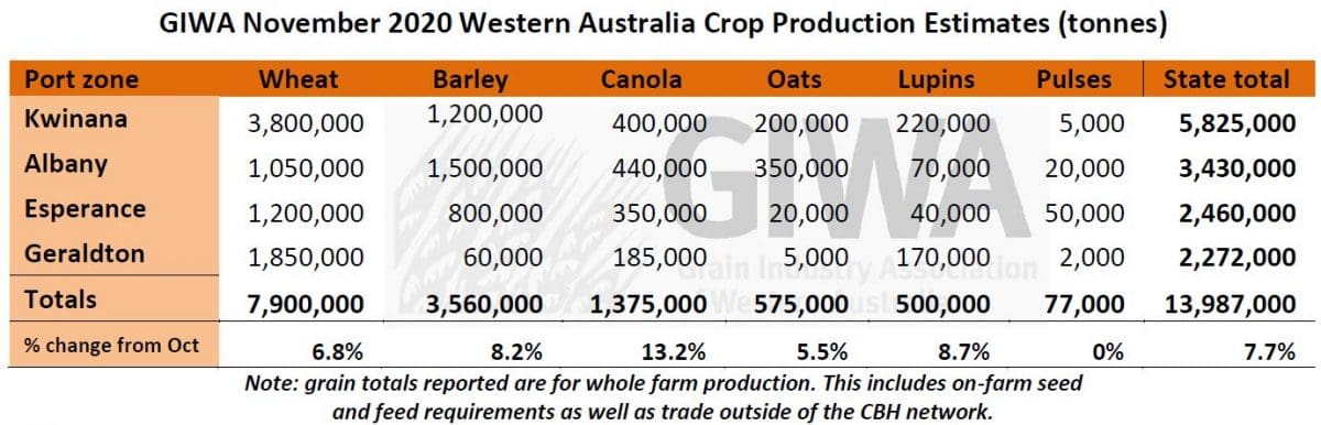
GIWA has lifted its November estimate for the state’s winter crop to nearly 14 million tonnes (Mt), an increase of 7.7 per cent since October.
Canola, barley and lupins are all yielding 10 to 20 per cent more than expected and the small tonnage of wheat already harvested is following the same trend.
If this continues as harvest moves south, there will be further upside to total state grain production against the forecast below and previous tonnages reported in October.
The indication prior to the start of harvest was that grain yields were going to be higher than expected, considering the lack of rain during spring and lack of sub-soil moisture reserves.
This is proving to be correct, with crops regularly exceeding insurance estimates by a fair margin.
For many growers, their crop Water Use Efficiency (WUE) is in uncharted territory, with greater than 20 kilograms of grain per millimetre of rain for cereals.
The warm growing season conditions that pushed crop growth along, cool temperatures during grain fill, with few heat stress periods and minimal frost, have all allowed crops to convert every drop of rain to grain.
There have been several severe wind events and pockets of hail where individual growers have lost grain.
For most growers, harvest is now more about the potential deterioration in grain quality if we continue to receive late season rain events followed by cool weather.
There is already some concern around fungal staining in wheat in the north of the state, and in barley and oats in the south.
Whilst most wheat varieties in the north should hold up on falling numbers given the several rain events, in the south there is already concern there may have been enough wet/dry days close to maturity for falling numbers to have dropped below acceptable milling levels.
Screenings are high in barley with few loads to date making malt.
It is too early to make a general comment on wheat grain size, although early signs are that whilst some loads have come in with screenings on the high side, most are expecting lower screenings than last year.
Canola grain yields to date have been very good, even in the areas receiving low winter rainfall, with oil percentages in the mid to high 40s, an exceptional result.
Lupin grain yields to date have also been very good in the north and central regions. Few milling oat paddocks have been harvested to date.
Zone-by-zone
Geraldton Zone
The region had a difficult and later start than normal, with several severe wind events resulting in poor emergence for crops on the lighter soils or those soils which lacked stubble cover. The total rainfall in the region was very similar to 2019 where 1.4m tonnes of total grain was produced, one of the lowest production years in recent times. In contrast, this year the zone is on track for at least 1m tonnes more grain than 2019, simply due to the timing of rainfall events and a cool finish with few heat shock events. The rainfall in 2020 was more at the back end of the season, with crop roots following moisture deep into the profile during the winter, then receiving some decent rain in August just as they were starting to stress from lack of moisture. It has been the distribution of rainfall, rather than the total amount, that has made the positive difference to production this year.
Combined with these conditions, the unusually mild temperatures in spring with fewer hot windy days during grain fill has enabled all crops to hit maximum potential grain yields. This is particularly evident on recently spaded, ploughed and deep-ripped country and paddocks with a history of soil amelioration.
The reported grain yields to date are exceptional with significant areas yielding in the low 2t/ha for canola and plenty of wheat returning whole paddock averages in excess of 3t/ha. Canola is about 70 per cent done and the wheat paddocks are about 30 per cent harvested. Only about 20 per cent of lupin paddocks have been harvested, with some of the best grain yields hitting the 2t/ha mark.
There is substantial variation in grain yields across soil types with the heavier soils struggling in the dry year. Crops in the eastern portions of the zone on heavy country are yielding well down on average.
Kwinana Zone
Kwinana North Midlands
Actual grain yields in the zone are well up on estimates. Canola is about 50 per cent complete with grain yields in the poorer areas which were estimated to go around 0.6t/ha, achieving 0.9 to 1.0t/ha. The better areas are yielding closer to 1.6t/ha, where they were estimated to reach 1.3t/ha. Some areas in the west of the region have yielded closer to 2.0t/ha.
Barley grain yields are up on estimates with pre-harvest assessments of 2.2 to 2.3t/ha actually yielding closer to 2.8t/ha. The poorer areas estimated to yield 1.5t/ha are going around 2.0t/ha. Quality is mostly feed due to screenings, with the current split on paddocks harvested around 80:20 feed to malt.
Fewer paddocks of wheat have been taken off so far. Those that have are potentially the better yielding ones and these are going in the high 2.0t/ha range, with a range of between 1.5t/ha on the heavy country and up to 4.0t/ha on the deeper soils in the western areas where there was more rainfall. Wheat screenings have ranged from 4 to 16 per cent depending on variety and soil type. Early indications are that there will need to be a bit of blending of loads although it does not look like screenings are going to be as high as they were in 2019.
The few lupin paddocks harvested have been in the 1.5 to 2.2t/ha range which is also better than expected. Lupins have benefited from the warm winter, putting on plenty of biomass and holding primary pods which can often be lost from heat or frost. The contribution in grain yield is coming from the whole plant this year, rather than from the later pod set.
There have been some savage hailstorms throughout the region in the last 10 days which have wiped out or reduced canola and lupin crops and caused head loss in barley. The storms were mostly isolated strips through the region rather than large areas.
Kwinana South
The region has had a slow start to harvest with several days of light rain over the last two weeks just as crops were ready to harvest and there have been few drying days in between the rains. The hailstorms that started further north licked into the north western areas of the zone, but luckily most growers escaped major crop loss.
Grain yields so far have been returning 10 to 20 per cent more than expected, consistent with the rest of the state. Canola grain yields in the eastern portions of the zone are mostly in the 1.0t/ha range, with some of the very poor areas going 500kg/ha and the better areas in the west going 2.5t/ha. Oil percentage has been good with most around 45 to 46 per cent and some up to 47 to 48 per cent.
Barley harvested in the eastern areas is in the 2.0t/ha range with high screenings and virtually no malt grade. Downgrading from the rain could be a concern when growers move onto wheat, particularly in the noodle varieties.
Lupins have grown well from the warm winter and from the road look to have good yield potential.
Kwinana North East
Grain yield reports so far in the Kwinana North East zone have shown a huge range depending on whether they are situated close to the strip of summer rain that started near Dalwallinu and continued south east to north of Hyden. For some, total effective rainfall for the year has been greater than 300mm and the yields are reflecting this. Grain yields of around 2.0t/ha for canola and high 1.0t/ha lupins are not hard to find. The edges of this good strip are still okay with canola yielding around the 1.0t/ha mark and barley in the 2.2 to 2.3t/ha range.
Grain yields drop off dramatically to the east and north east to areas where there is little to harvest and plenty of wheat crops struggling to hit 1.0t/ha. To the west and south west of the good strip, grain yields are down on average, although most growers have been surprised to find crops yielding up to 20 per cent more than expected. Some of the very dry areas in the south and south west in the zone around Tammin / Kellerberrin and around Bruce Rock / Narembeen are harvesting 1.2 to 1.5t/ha barley crops which is quite amazing considering these areas are in decile 1 winter rainfall zone for 2020.
Albany Zone
Albany West
The West Albany region has had up to 80mm of rain in some places in the last 10 days. The pretty handy rainfall events that could have been useful a month or two ago have not caused too much damage to unharvested canola, although growers are worried about fungal staining in barley crops and falling numbers in wheat.
Early indication from canola harvested is that it is yielding more than expected with most going over 2.0t/ha. Crops in some of the dryer areas around Darken have gone 2.2 to 2.3t/ha and some of the better regions east of the Albany Highway have gone 2.5 to 3.0t/ha.
Harvest has a long way to go in the region. If indications from further north where more crop has been harvested continue to hold true, it is going to be another very good year for growers.
Albany South
Between 20 to 40 per cent of canola crops have been harvested in the region depending on where you are located. In the north around Ongerup pre-harvest estimates of 1.5 to 1.6t/ha have yielded 2.3t/ha and in the poorer areas that suffered early establishment problems from wind, with pre-harvest estimates of 1.5t/ha, yields have made 1.7 to 1.8t/ha. Some of the poorer rainfall areas around Jacup and Boxwood have only yielded in the 1.0 to 1.2t/ha range, although this is not a bad result considering the lack of rainfall.
Some swathed canola crops that have not been harvested are expected to have lost some yield from wind and there are some reports of head loss in barley crops. There are no reports of barley yields from the region as there are still green patches in paddocks around the wet areas.
There has been a bit of frost damage in the region and whilst the yields reported here are representative of paddocks harvested so far, some have come in well under 1.0t/ha due to frost.
Albany East (Lakes Region)
Most of the recent heavy rain fell west and east of the region. Crops harvested so far have yielded up on expectations. There are a few poor spots that will be well down on average yields as previously reported, although for most growers it is going to be one of the best harvests for several years, barring no major weather events.
The increased area of canola that was planted in the region this year is going to pay off for those growers who have brought the crop back into the system, in both cash and rotational benefits. The grain yields reported so far are in the 1.0 to 1.2t/ha range, rather than closer to the 0.8t/ha estimates.
Barley crops in the better areas are close to or just over 3.0t/ha with most around 2.1 to 2.3t/ha, about 300 to 400kg/ha more than estimated. Barley in the poor areas around Lake Grace and east to Hyden are in the 1.2 to 1.5t/ha range and the heavy country around Lake Grace and up to Kondinin sub 1.0t/ha.
Lupins are coming in at around 1.0t/ha which is a little less than they promised, although most growers are happy to take that.
Esperance Zone
The current total grain production estimate for the zone is sitting just under 2.5mt. There is still a fair way to go in the region and whilst growers have been targeting the better crops, there is potentially some further upside to current estimates. There has been some wind damage to crops accompanying the recent rain fronts and some wash in isolated places from the heavier dumps of rain, although most crops have not suffered significant yield loss yet. Grain quality is possibly going to be an issue for both wheat and barley if there are too many more wet days.
All crops are yielding better than expected and some by a lot more. Reports of 3t/ha canola and 6-7t/ha barley on the coast have not been unusual and plenty of crops within 70km of the coast going up to 2.0t/ha for canola and around 4.0t/ha for barley. Grain yields drop off pretty quickly in the dry areas north of Esperance, with areas around Salmon Gums mostly under 1.0t/ha for barley.
The areas in the south west of the zone around Ravensthorpe that have had a torrid time in the last few years are returning 1.2 to 1.5t/ha for canola and 2.5 to 3.0t/ha plus for barley, with some growers returning whole paddock averages of 3.5t/ha. Canola oil percentages have been very good, even at reasonable grain yield levels, with some growers hitting 49 per cent in 1.5t/ha crops. North of here in the zone, canola, barley and oaten hay crops dominate the plantings and all have been yielding above average.
The lack of frost this year in the frost prone areas highlights what crops can do if they are not knocked about by frost in the spring.
There have been no reports of lupin yields as growers have been concentrating on harvesting the dollar crops first.
Season Outlook
The WA Department of Primary Industries and Regional Development’s Ian Foster said that after a growing season that delivered well below average rainfall, the first part of November had been notably wetter than normal.
Many parts of the cropping region have already exceeded November average rainfall, with widespread harvest delays, some rain and hail damage, as well as quality risks to standing crops.
The latter part of November should see a return to normal rainfall probabilities for the time of year.
These events are consistent with the shift in rainfall probabilities indicated by climate models from November onwards, most likely influenced by the current La Nina event in the Pacific Ocean.
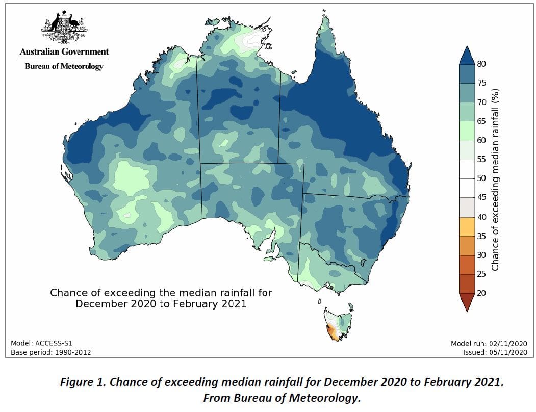
Figure 1 shows the chances of exceeding median rain for December 2020 to February 2021 from the Bureau of Meteorology’s ACCESS-S1 model.
DPIRD’s statistical model has a mixed rainfall outlook for November 2020 to January 2021, based on October global climate.
Bureau of Meteorology seasonal outlook summary, issued 5 November 2020
- December to February rainfall is likely to be above average across most of Australia, except west coast Tasmania.
- Daytime temperatures during December to February are likely to be warmer than average across parts of south-east and far-west Australia, as well as along the northern coastline.
- Night-time temperatures during December to February are very likely (greater than 80 per cent chance) to be warmer than average across almost all of Australia.
- La Niña is underway in the tropical Pacific. La Niña typically increases the likelihood of above average rainfall across much of Australia during spring and early summer.
- A positive Southern Annular Mode (SAM) may also enhance rainfall over eastern Australia during the coming month.
Source: GIWA
Grain Central: Get our free cropping news straight to your inbox – Click here
HAVE YOUR SAY