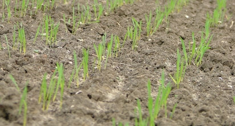
WESTERN Australia’s winter crops are up and growing across the majority of the grain belt, making up ground after copping a blast of wild, windy weather in late May when many were in the early stages of establishment.
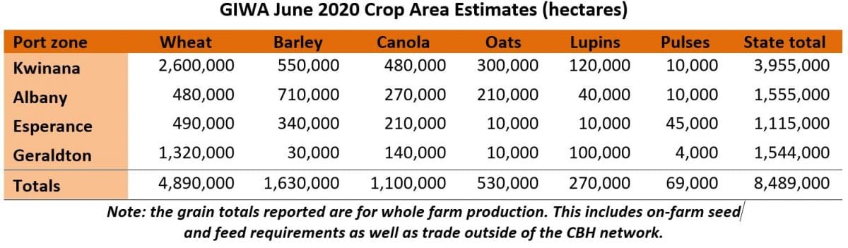
The Grain Industry Association of WA’s (GIWA) Crop Report for June, released today, estimates the sown crop area across the state will be up on 2019 to an estimated 8.489 million hectares (Mha) due to summer rain in some regions and a positive seasonal outlook in March/April giving growers confidence to plant more area.
There has also been a slight substitution of pasture to crop across large areas of the grain belt from reduced livestock numbers.
GIWA estimates the state will end up planting 4.89Mha of wheat, 1.63Mha of barley, 1.10Mha of canola and 530,000ha of oats this season.
GIWA Oilseeds Council chair and crop report author, Michael Lamond, said the estimated area for lupins had been reduced from last month’s figure of 320,000ha to now be around 270,000ha.
Many of the intended lupin plantings in the traditional “lupin belt” on the sandplain in the western areas did not go in, substituted to wheat. The lupin area in the region is estimated to be down by up to 40 per cent in some areas.
“There has been a substantial reduction in lupin area because a lot of growers in the north backed off when it was starting to dry. Then when they got the wind and rain they just baled on lupins and went to wheat,” he said.
Mr Lamond said crops across the state were now recovering well after the wild, windy weather.
“It gouged out the controlled traffic run lines and caused a fair bit of damage. The main damage has been furrow fill which delayed crops coming through, but since then it has been so warm the crops are packing on nearly two leaves a week, so they have made up ground,” he said.
“Even though the break was a bit earlier than last year and there was delayed emergence, the majority of crops have made up ground. They are probably a bit in front of last year now.”
Mr Lamond said the estimated canola area had come back a little, but it was the estimated barley area that had dropped significantly from 1.9Mha in May to 1.6Mha in June due to China announcing it would impose an 80 per cent tariff on Australian barley imports.
“There was quite a movement away in the malt belt. A lot of the malt growers went to wheat,” he said.
“In the southern areas there has been very little change because they are all feed growers. The yield advantage of barley when you grow it for feed and the profit margin, even at $260/tonne for barley, is still better than wheat.”
The oat area in WA is up significantly from 2019 with dedicated hay growers continuing to plant more area and the substitution of oats for grain from barley that occurred in the last couple of weeks in May.
Mr Lamond said growers were looking to more rain forecast next week to shore up production.
“There are still big chunks of the grain belt that haven’t got subsoil moisture, so we are looking at an average crop at best across the state,” he said.
“In saying that, the west and Albany, the Lakes district and the central west coastal areas are very good. And there are some eastern areas that are very good, and they are massive areas of production if that continues.”
Zone by zone
Geraldton Zone
The first round of seeding finished two weeks ago and the second round of seeding is winding up now, although some growers are moving into their third round. The extreme winds prior to the rain with the frontal system that went through two weeks ago in the region caused widespread furrow fill which has required many crops to be re-sown. The worst affected country was the on the ameliorated sandplain. The intensity, duration and primarily north/south direction was unusual, and even where country was not ameliorated and had retained sanding stubble, there was still damage to paddocks along tram lines and the ends of seeder runs.
Decisions around re-sowing crops are very difficult and many younger growers had not experienced an event like this before. Even though there are extra costs and a time cost with re-sowing, those that have are commenting crops are coming through beautifully from being planted into a moist warm seedbed.
Prior to the wind event and the opening rains following it, growers had backed off with lupin and canola plantings due to the lack of sub-soil moisture and the risk it poses with a late break. Many of the intended lupin plantings in the traditional “lupin belt” on the good sandplain in the western areas did not go in, substituted to wheat. The lupin area in the region is estimated to be down by up to 40pc in some areas. Some canola paddocks were re-sown to wheat although as most had not germinated and was not cut off by sandblast most paddocks have come through with enough plants to make a reasonable crop. The barley area is well down on previous years, more of a planned move by growers as the break to the season became later.
The eastern areas of the zone are looking good as there was less wind blow and the crops have a bit of sub-soil moisture under them.
Kwinana Zone
Kwinana North Midlands
Seeding has finished in the region except for some of the late sown soil ameliorated paddocks that were done after the opening rains. Rainfall in the region has been variable ranging from 15-35mm from opening rains two weeks ago. Crops that received around 15mm are patchy and have variable emergence whilst areas that received more rain look ok to good. The coastal and central areas of the zone are behind crops in the eastern areas of the zone where there were some good earlier falls of rain.
Some areas in paddocks have needed re-sowing from the wind event, although nowhere near to the extent further north. Crops have been slow to come through due to furrow fill and lack of rain. Some of the earlier sown crops in the east are up to 5 leaf and tillering although the majority are less than 3 leaf. In some places the canola is still coming though and will benefit from the rain we are now having.
Barley area is down substantially in the region. The region is a large producer of Malt barley and this is where the biggest reductions in plantings have occurred. The barley area in the region is estimated to be down by 20-30pc largely replaced by wheat and to a lesser extent to oats.
Even though crops have grown very quickly in the last week from the unseasonably warm temperatures to make up ground in growth stages from the later break, most growers in the region are planning for a below average season and are adjusting fertiliser decisions based on a lower production year. Soil nitrogen levels are generally higher than normal and with the revised climate outlook pointing a lower rainfall year most growers will hold back on pushing crops along too much unless there is some very good rainfall in the next couple of weeks.
Kwinana South
The region is a tale of two halves with the central and western portions of the zone later to get a start and the eastern areas green. The majority of the zone received their opening rains two weeks ago and the ground has soaked up the rain like a sponge from being so dry. Crops were initially slow to get up although they have rocketed along from the warm temperatures and have made up ground to be at growth stages that could result in average yields at the end of the season if the rain keeps coming.
Canola in particular has taken a long time to come through as have some cereal paddocks that received significant furrow fill from the wind event. Most growers in the zone are factoring an average year at best at the moment, whilst those that had crops up earlier in the east are quietly hopeful of an above average year.
There was a 10-15pc drop of intended barley plantings in the region with more being dropped in the western areas where there is a higher percentage of barley in the rotation and a greater percentage grown for Malt. The remainder of the region did not pull back as much on barley plantings as the crop is grown as much for weed control and frost mitigation and generally out yields wheat by 0.5t/ha to 1.0t/ha. Some of the substitution out of barley has gone to oats as it has in other regions of the state resulting in a significant kick in plantings of oats this year over the last few years.
The canola and lupin areas are similar to last year with a slight increase in canola plantings as you move into the eastern areas of the zone due to the earlier break to the season for some growers.
Kwinana North East
Crops in the North Eastern Kwinana zone are generally ahead of where they were this time last year as they are further advanced in growth stage and much of the zone has some reserves of sub-soil moisture. In saying this there are still some growers in the lower rainfall areas of the zone without a break to date.
For some growers there is enough sub-soil moisture to return above average grain yields from an average winter rainfall year.
Albany Zone
Albany West
The west Albany zone is in good shape with most of the crop sown prior to the end of May. Establishment has been good to ok and even though crops have started to “tongue” it for water following the warm days in the last week, most are holding up ok.
There were no major changes in crop area from the previous Crop Report last month and no major changes to planned programs from earlier in the year.
The soil moisture profile is low and the region is well down on average rainfall for this time of the year, although most growers are not worried at this stage of the growing season as the region has plenty of time to produce above average tonnages with the timing of the start that the region received.
Crops have gone in noticeably earlier this year than previously and whilst crops were a “bit stressed” on the low water holding capacity forest gravels, the rain has come along just in time and these crops will be more able to handle the waterlogging that invariably occurs in the winter in the region.
Albany South
Crops west of the Albany Highway look good although as you move east in the zone crops become patchier and to where some are just emerging from the light rainfall two weeks ago.
Canola crops have below average grain yield potential due to the late start and cereals a bit below average potential. There was a small swing out of barley that was originally planned to go into canola which was adjusted due to the late start and many of these paddocks ended up being planted to wheat.
The surface water situation for much of the zone is still critical and growers are still turning off stock in big numbers.
Albany East (Lakes Region)
Crops in the region have “got away” well, with the amount and timing of rainfall just enough to keep them moving along. Some of the earlier crops are patchy and here has been some re-sowing of canola due more to germinating and running out of moisture rather than furrow fill as has been the case further north. In the main, the early barley and oat crops look very good.
Growers in the region have had a tough few year with below average rainfall and severe frost and while there is a long way still to go, the region has had the best start for 3-4 years.
The crop area mix has changed little from last year with a slight increase in canola area from the better start and a slight drop in barley area being substituted to wheat. The majority of barley was sown in the region when the new season price correction occurred and barley suits the region more than other cereals so the adjustment in planted area was never going to be significant.
Esperance Zone
The bulk of the region has received only patchy rain to date. The crops in the western parts of the zone are in better shape at this stage of the season than they have been for several years, whilst areas to the east range from good in the far east of the zone and right on the coast and some areas around Salmon Gums, to just average to below average in the central areas of the zone.
Crop growth stages vary a lot due to the timing of rainfall events and the amount of rain. There are some very advanced crops and some just coming through, many have staggered emergence. Recent rainfall whilst only light has evened out the crops with more crop up in the unevenly germinated paddocks to a state where “they will do”.
The lack of surface water for livestock has not changed with the light rainfall events and livestock are still “streaming” out of the region resulting in a slight increase in crop area. Some areas around Cascades in the central western areas are extremely dry.
In the end there was a slight pulling back in barley area from wheat/barley paddocks to wheat/wheat paddocks. The bean area is noticeably up from last year, peas about the same as 2019 and lentil area down from last year.
The zone overall is only looking at an average year at best at this stage, although the good start in the western areas of the zone could significantly push the zones’ tonnage up if the season ends up with average rainfall and no significant frost events.
Season outlook
The WA Department of Primary Industries and Regional Development’s Ian Foster said autumn rain had generally been below average for the cropping regions. The main rain events in May occurred early and late in the month, and totals were patchy away from the South West. These also brought strong winds and soil erosion. South Coastal areas are entering their third winter with low levels of surface and soil water availability.
Modelled soil water storage at the end of the first week of June is highly variable across many cropping areas, with low storage for the far northern region and the South Coast. This reflects patchy rain to date (see Figure 1). Recent conditions have also seen significant soil erosion over paddocks with low surface coverage. Short-term rain outlooks indicate a rain event over 11/12 June but overall the month is predicted to be drier than normal for southern WA.
Seasonal rainfall outlooks from the Bureau of Meteorology and other models have a spread of rainfall probabilities for southern WA for July to September. The Bureau’s model has a neutral outlook.
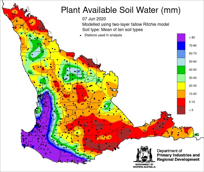
Figure 1: Estimated soil water storage for WA at 7 June 2020 using a fallow water balance model. (Source: DPIRD)
Bureau of Meteorology seasonal outlook summary, issued 4 June 2020:
- Winter (June to August) is likely to be wetter than average for northeast South Australia, western New South Wales, and scattered parts of southern Queensland. However, coastal south east SA, south west Victoria and most of Tasmania are likely to be drier than average.
- The month of June is likely to be drier than average for scattered areas of the south.
- Winter days are very likely to be warmer than average across most of Australia, except southern SA, south west NSW and western Victoria, which have roughly equal chances of warmer or cooler winter days.
- Winter nights are very likely to be warmer than average almost nationwide.
- To Australia’s east, the central and eastern tropical Pacific Ocean is likely to cool over the winter months, establishing a La Niña-like pattern, while warmer than average waters are likely in the eastern Indian Ocean. In the shorter-term, higher pressure is likely to dominate southern Australia during the first half of June.
Source: GIWA
Grain Central: Get our free daily cropping news straight to your inbox – Click here
HAVE YOUR SAY