RECENT unexpected early spring rainfall in Western Australia has helped with crop grain-fill, although for most regions of the WA grain belt it will only buy another week or two until more rain is needed to avoid a sharp drop in grain yield potential.
 In its latest crop report released today, the Grain Industry Association of WA (GIWA) says the bulk of the grain-belt has run out of, or will soon run out of, stored moisture.
With the weather warming up and crops at peak water use, more rain is urgently needed to avoid crops crashing and not achieving current grain yield potential.
The next two weeks will largely determine the final outcome for the year.
Crops on heavier soils and in the lower rainfall regions are showing signs of moisture stress now, whilst the majority of the grain-belt could hang on for a week or two before grain yield potential falls away.
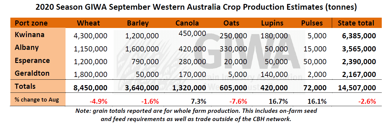
Total grain production for the state is estimated to be 2.5 per cent less than last month. If no significant rain falls in the next two weeks, the decrease in tonnage could exceed 10 per cent from current estimates.
In contrast to the majority of the grain-belt, the western rim of the grain-belt fanning out to the western great southern regions is in very good shape, and most of these areas are on track for average to above average grain yields. The area west of the Albany Highway is in particularly good shape and barring frosts events in the next month, will pull in large tonnages.
The season is looking like an early finish for most of the state, with canola and barley harvesting projected to start a week or two earlier than normal in the low rainfall regions. In an early start to the hay harvest, hay crops are being knocked down now to avoid colour loss due to moisture stress in the lower rainfall regions. It has been a low disease and insect pressure year except for budworm in the north of the State.
It is too early to make a call on grain quality although without some decent falls of rain in September, cereal screenings could be up around 2019 levels in regions with lower than average growing season rainfall.
Zone-by-zone
Geraldton Zone
The majority of the zone is still in good shape thanks to some useful falls of rain in August coupled with mild spring temperatures. There have been the usual occasional hot days with wind, although not for extended periods of time. The crops are relatively early, and grain fill is well underway. Some potential has been lost on the heavy soils in the east and grain yields will vary depending on where the summer rain fell.
Total expected grain production has remained similar to last month, with some areas improving and some backing off. Crops are still looking “better than they should” for the rainfall and many growers are worried that without mild conditions and at least another rain, the slide in potential could occur very quickly, with the potential “too high” for the rainfall.
The extended flowering time for both lupins and canola is likely to result in some good grain yields.
Kwinana Zone
Kwinana North Midlands
The outlook for harvest across the region is below average. The western areas that picked up good falls of rain in August have improved from where they were a month ago, although most of the zone has simply run out of soil moisture. There is real concern that without rain in a week to ten days, crops are going to slide very quickly and grain yield potential could we way down from where they are now.
The central north/south corridor that has struggled all year is already showing signs of moisture stress and there has been a backing off in potential yield for most crops since last month. Even though compared with last year crops in general have had more potential up until now, there is no back-up moisture in the profile and this is will come into play with a warm week and no rain forecast in the short term.
The majority of the traditional barley belt in the area is now expected to be well down on average yields.
There are some bright spots in the east of the region and crops that received summer rain are still in good shape. There will be some very good grain yields in patches, although it won’t be enough to make up the lower than average expected grain yields in most of the zone.
Kwinana South
The higher rainfall regions of the Kwinana zone are now average to above average for all crops. This decent area hugs the coast closer than normal with the rainfall dropping off very quickly moving east. The central corridor in the medium rainfall zone is going to be below average no matter what happens now. This north/south corridor has had well below average rainfall for the year and crops are starting to reflect this.
Rainfall for the year picked up in the east bordering the Kwinana North East zone and crops through there currently have higher grain yield potential than further west. In saying this, there are still patches well down on average growing season rainfall.
The switch out from barley to wheat due to the imposition of China barley tariffs in May was greatest in this area of the State and whilst wheat has more ability to “tough it out” in a tight finish, most wheat crops are later than the barley crops and will need another rain to hit current grain yield estimates.
Lupins look very good with decent growth and lots of pods. This central region of the State has more lupins in the ground than we previously estimated and coupled with the season suiting lupins, has resulted in an increase in estimated tonnages this month.
Some early sown oat crops are being dropped for hay now, a management decision growers are making earlier than they normally do.
Kwinana North East
The lower rainfall regions of the zone have some excellent cereal crops with well over 2T/ha potential where there was summer rain. The grain yield potential drops off very quickly to the north and east of this strip with some crops on heavy country still nearly bare. This region will still pull in some tonnes as the good areas are “very good” for all crops.
The swing in tonnage out of this region could be quite large as the slide in potential yield has not yet started from lack of sub-soil moisture. With another rain in the next week or two, crops will hold current potential yield.
There was some swing into oats in these lower rainfall regions and in the areas which didn’t receive summer rain they have really suffered from the dry conditions.
Albany Zone
Albany West
Rainfall over the last two weeks of between 30-40mm for most of the region has been perfect for crops and the whole zone west of the Albany Highway is set up now for a very good year. Crops have picked up east of the Albany Highway as well and with a few more rains will have average to above average grain yield potential.
Most cereals are out in head and there have been no significant frost events so far. The cereals are more advanced than they have been for several years and with little waterlogging during winter and disease light on, growers are expecting some good tonnages to come in and looking forward to harvest.
Canola and lupins are well grown and have had extended flowering periods. Both crops are expected to be above average at harvest if the season keeps tracking as it has recently.
Oat crops are also very good and this region will be one of the few areas in the State where oat left for grain will achieve close to average grain yields.
The only downside to the year has been the lack of surface water run-off in crop paddocks to fill dams. Pasture growth has been poor all year in this region, as it has been across most of the grain-belt. Growers are already preparing to turn off dry and surplus sheep stock, rather than struggle for feed through the summer.
Albany South
The season has “turned around” in this part of the State over the last month, the catalyst being the good dump of rain in early August that helped to even-up paddocks from the very patchy start. Tonnage in the region is predicted to still be below average and more rain is needed to fill current grain yield potential.
Cereals are in the 1.5-2.0T/ha range in the lower rainfall areas, with better crops in the higher rainfall areas 2.5-3.0T/ha, which is well down on long term averages. The region usually has a longer growing season and if more rain falls in September there will be an upside to current predicted grain yields. Canola is still going to be variable, with current grain yield range from 200kg/ha to 1.5T/ha.
Albany East (Lakes Region)
The hopes of an above average year for most is now fading except for growers that received over 20mm of rain in the last few weeks. The recent rain was “just what was needed” and has bought some time before grain yields will drop off. The areas that did receive the higher amounts of rainfall will get through a few more weeks and the areas with less rain are showing signs of drought stress now.
There is still the very good strip of country in the east of the zone bordering on the western edge of the Esperance port zone that is on track to be above average at the moment. This is despite most of this area missing out on double digit rainfall events. Growers will be relying on stored soil moisture to maintain current grain yield potential.
Crops are more advanced in growth stages than they have been in recent times and there has been minimal frost so far which is a bonus. These two factors will help and growers are hoping for mild conditions and some more rain in September to get crops over the line.
As they are in other areas of the State, crops are variable across the region and the poor strip north/south from Pingaring to Lake Grace that has missed out on rain all year will end up well below average. This variability across the region makes it very difficult to estimate potential tonnage at harvest. The next two weeks will largely determine the outcome.
Canola and lupins are in better shape than they have been for several years in the region and the warm growing conditions this winter have helped to get some bulk on the crops. In contrast, pasture has been tight all year and growers are going to be hanging out for stubbles for sheep.
Esperance Zone
Grain yield potential has improved over the last month for the zone from an “evening up” across the region from a reasonably good August for most growers. In general, most growers are expecting average to good grain yields for all crops.
Some potential has come off the very good strip in the west of the zone, and the northern areas have not picked up from where they have been all year. Areas in the remainder of the zone that were a bit light on for rain that picked up good fall in August will mostly be average, particularly on the sandplain soils. In the north of the zone on the mallee, soils crops are showing the effects of lack of rainfall and will need a drop of rain within the next week or so to hold grain yield potential.
Barley is in better shape than wheat and will rely less on September rains due to its more advanced maturity. Wheat is just starting to fill heads and will need more rain to hit current grain yield potential.
Canola is “all over the shop, as it is across the whole south coast, and grain yields will vary mostly on how well the canola established at the start of the season. Lupins are very good, as are the faba beans, field peas and lentil crops, with good growth and plenty of pods.
Disease pressure has been low all year and “jack frost” has stayed away, except in some spots in the north west of the zone.
Season outlook
DPIRD’s Ian Foster says seasonal rain since April has been below average for a region running from the Mid-West, through the central agricultural area and into the Lakes district. August saw a couple of key rain events that saved crops in the northern agricultural area and relieved water shortages along the South Coast. Early September brought useful falls across western parts of the northern and central agricultural areas as well as much of the Great Southern. Eastern South Coast received little rain. Prediction for the second part of September is for below average rainfall, and this is likely to elevate frost risk.
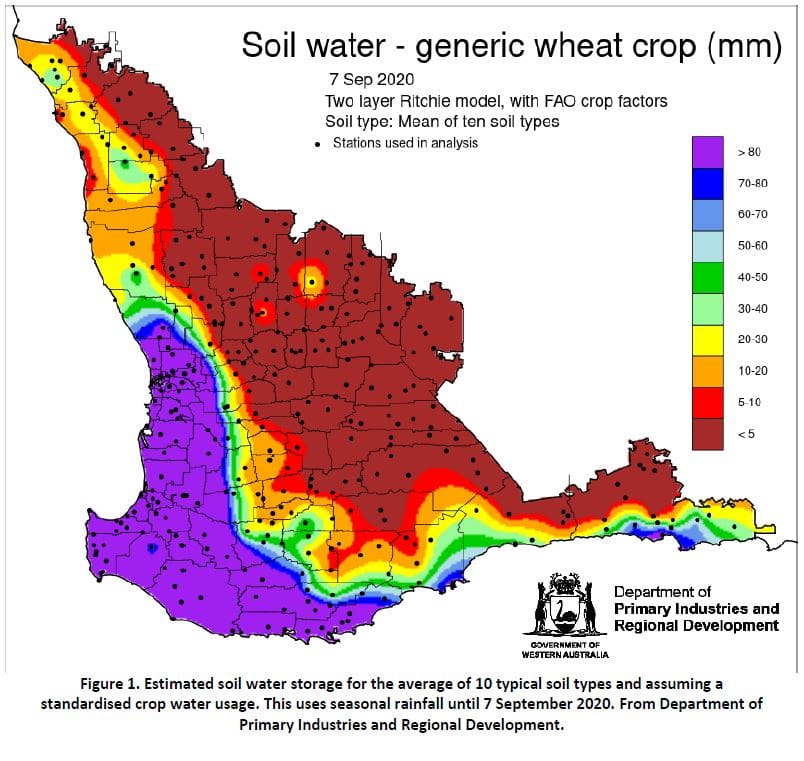
Modelled soil water storage in early September (Figure 1) shows the results of seasonal rain and simulated crop water usage, with large parts of north-eastern, central and eastern agricultural areas sitting on small amounts of soil water. This clearly puts crops at risk of a sudden finish to the season. Seasonal temperatures to date have been 1 to 2 degrees C above average and are likely to have accelerated crop development.
Seasonal rainfall outlooks from the Bureau of Meteorology and international models have a spread of rainfall probabilities for southern WA for September to November. The Bureau’s model has a neutral to drier outlook for much of the cropping region, especially the north. DPIRD’s statistical model has a similar outlook.
Bureau of Meteorology seasonal outlook summary, issued 3 September 2020:
- The spring outlook indicates a wetter than average three months for the eastern two thirds of Australia but drier than average for west coast Tasmania, and large parts of west and north-west WA.
- Spring days are likely to be warmer than average for most of Australia. Chances of warmer or cooler than average days are roughly equal for the west and south coasts of WA.
- Spring nights are likely to be warmer than average over most of Australia. Chances of warmer or cooler than average nights are roughly equal across south-west WA.
- Ocean and atmospheric indicators in the tropical Pacific Ocean are consistent with La Niña development. The Bureau has an ALERT status for this.
- The Indian Ocean Dipole (IOD) index has been at negative values for the past three weeks; most models anticipate this will continue long enough to be considered a negative IOD event.
Source: GIWA
HAVE YOUR SAY