WIDESPREAD rain over the central regions of Western Australia in the past month have arrested the slide in winter crop grain yields and added at least 500,000 tonnes to the Grain Industry Association of Western Australia’s (GIWA) latest estimate for WA production.
GIWA is now predicting the state will produce 15.653 million tonnes (Mt) of winter crop, up 9.9 per cent from last month’s estimate.
The rise in cereal estimates now sees the state’s wheat production likely to reach 9.1Mt and barley 3.9Mt.
GIWA Oilseeds Council chair and report author, Michael Lamond, said as harvest gathered pace, yields were proving better than expected thanks to the improved conditions of the past month.

Michael Lamond
“Rain since the last report across the central area was just in the nick of time for the wheat. It added quite a bit of tonnage,” he said.
“Since then it has been unusually cool across the whole wheat belt. So, in the north where growers had been thinking the worst, the cooler temperatures allowed the crops to finish more slowly and they have come back to how they were looking before.”
Mr Lamond said while grain protein levels were low, the above average yields were likely to see the current projections being exceeded.
“Total tonnage for the state is now on track for an above average harvest with some upside to our current estimates,” he said.
“There are 1.6 million hectares of barley, the largest ever. Only small increases will give a kick there. With wheat, even the bad areas aren’t as bad as people thought. So, I think there is some upside to the tonnage.
“We are only predicting 1.4 million tonnes of canola across the state. It could go more than that because every paddock that is being harvested in the north is going better than thought.”
Mr Lamond said harvest was progressing throughout the state.
“They are well into harvest up north. They are just getting cranked up in West Kwinana. In East Kwinana there is a fair bit of barley that has come off and they have started on the wheat. They are just getting underway at Esperance. There is not a lot harvested yet south of the Great Eastern Highway, although there has been a fair bit of harvesting gone on east of Kellerberrin, Narembeen and Bruce Rock where they got the crops in a bit earlier,” he said.
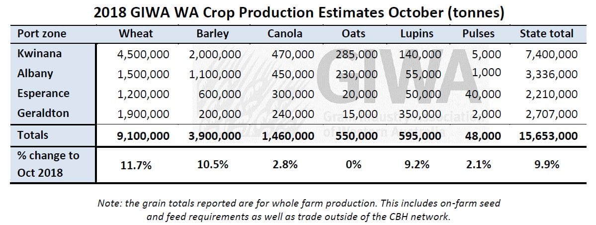
Source: GIWA. (Click on table to enlarge)
GIWA’s zone-by-zone crop report
Geraldton Zone
Crops harvested to date for the Geraldton region are yielding higher than expected.
The northern agricultural zone missed out on the October rain that fell in the central regions and growers were watching their grain yield potential fall from the very high expectations earlier in the year as time passed.
Most were fearing the worst, knowing that when the heat came on in the spring, the lack of rain would make it difficult for crops to finish.
As it turned out, September and October were very mild and these mild temperatures have had a significant effect on allowing crops to mature more slowly and achieve higher yields.
Whilst this was also the case for the rest of the grain growing regions, the impact has been greater in the north where there was more of a “bucket” of moisture to access.
Early indications are that the wheat is yielding “as good as it looks” and is closer to earlier predictions with paddocks harvested to date around 3.0t/ha rather than 2.5t/ha.
Most barley is yielding at least 3.0t/ha and in the southern higher rainfall regions of the zone, well above this.
There is some barley leakage out of the zone to the southern regions where there are more segregations and marketing options for malt.
Canola is yielding between 1.5t/ha and 1.8t/ha with some in excess of 2.0t/ha on the deeper better soils.
This is well above earlier predictions of 1.2t/ha to 1.4t/ha where the later start and time at flowering was expected to limit top end yields.
The few lupin crops harvested so far are yielding very well with some going close to 3.0T/ha.
The standout all year has been crops on the ameliorated country, with growers now regularly differentiating their crop potential on ameliorated and non-ameliorated paddocks.
Kwinana Zone
The Midlands
In the middle of the grainbelt less crop has been harvested with barley crops yielding higher than expected and the few swathed canola crops also yielding higher than expected.
Barley yields in the western areas of the region are in the 3.6 to 3.7t/ha range and 2.75t/ha to 3.5t/ha in the east.
Canola grain yields are coming in about 0.1 to 0.2t/ha more than expected with paddocks going 1.5 to 2.0t/ha in the western areas, paddocks in the eastern areas are around 1.0 to 1.5t/ha.
Canola oil percentages are more in the mid-range of 44 to 47pc rather than the high 40s as was expected due to the cool mild finish.
Lupins are well podded and look to be around 1.8 to 2.2t/ha potential in the west and 1.4 to 1.6t/ha in the east. Most crops are hanging on and there are no reports of harvested yields at this stage.
The western area of the zone is a relatively large export hay growing region, and the cold weather has held things up and resulted in a drawn out process to get the hay baled up and out of the paddocks. Yields have been exceptional with 7 to 9t/ha for good oaten hay country.
Overall for the zone, waterlogging damage in the western areas has limited potential grain yields, the medium rainfall zones are looking excellent and the eastern areas are holding up well and will contribute significant tonnages to the region.
Kwinana West
There is very little crop off in the West Kwinana zone. Going on indications further north, most growers are quietly optimistic about the upcoming harvest with grain yields for all crops expected to be above average.
The waterlogged areas have slowly recovered and the better areas look to have well above average grain yield potential.
Most crops were able to take advantage of the October rains and combined with the slow cool finish should yield very well.
The eastern end of the West Kwinana zone that had an earlier start than the rest of the state has suffered more from the September frost events and most growers who cut the low lying areas for hay are happy they did.
Grain yields will be closer to average because of having the top taken off paddock yields due to the frost.
Kwinana East
The barley crops in the region were too advanced to benefit from the rain in October with paddocks harvested to date mostly under 1.5t/ha north of Merredin.
The low rainfall areas in the east and north of the region were patchy all year depending on soil type, rain from isolated storms or if it was fallowed last year, resulting in a wide range of grain yield potential.
Barley crops in the Kwinana East zone are ranging from barely 1t/ha to over 2t/ha.
To the south and west, yields are reasonable with crops around Kellerberrin down to Bruce Rock going 2.5-3.0t/ha.
The wheat looks to have benefited more from the rain as it was less advanced and while many wheat crops were pinching off from the tops of the heads when the rain came, most should out-yield barley.
Canola seems to have held up fairly well being aided by the cool finish to the season and most should yield at least average in the southern regions of the zone.
Lupins have podded up well as they have in most areas of the state and grain yields of 1.5-2.0t/ha are expected.
Albany Zone
Western Albany
Cereals in the western Albany zone look exceptional. Crops are still filling and the recent rain will benefit wheat crops.
Barley has ‘looked the goods’ all year and will return above average grain yields.
Barley in the region got off to a good start and held up well in early August when some paddocks became quite waterlogged.
Management of most barley crops was excellent for the region this year with the expectation of high prices and this is starting to show up now as the crops get close to harvest.
Canola in most cases will be only just average with expected tonnage down on recent years.
The frost events in September seemed to have had a limited effect on the cereals as most were not advanced enough to be affected.
Grain yields in the western areas will hold up the zone, as you move to the eastern areas and southern areas yields fall away due to the dry conditions and frost.
For some areas in the eastern areas of the zone grain yields will be well below average, particularly around Gnowangerup, Nyabing and Ongerup.
Southern Albany
The Southern Albany zone has continued to improve all year following the very difficult start and now has a chance of achieving average grain yields.
This is a general overview as individual paddock yields are going to be hugely variable.
The canola paddock yield range could be between 400 kilograms/ha to 2.5t/ha depending on establishment density, timing of rain, frost influence and management during the year.
Cereals will not have quite this range although they are also going to be variable.
The potential drops off dramatically as you move to the eastern areas of the zone bordering the Esperance Port zone.
South of the ranges from Wellstead west, most grain yields for all crops will be average.
The extra barley sown late on failed canola crops has been impacted by the very dry September and October.
Overall barley tonnage will be down from increased area planted.
The wheat is struggling from lack of finishing rain and is starting to go off quicker than growers would have liked.
Cereal crops mostly escaped the frost along the coast and will be at least average.
Conditions deteriorate dramatically travelling east towards Gardner and north of the ranges from the well below average rainfall and frost.
Eastern Albany (Lakes Region)
The lack of rain all year combined with several frost events has severely limited the grain yield potential for the region.
There is a dramatic slide in grain yield potential from north to south with some wheat crops around Kulin, Kondinin and Hyden likely to exceed 3t/ha, as you move south to Lake Grace and Newdegate, wheat will be in the range of 1.2 to 1.5t/ha.
Most growers in the northern and eastern areas are expecting above average grain yields for cereals and yields well below average in the southern areas, particularly where there was a lack of rain and several frost events.
There are pockets of frost right through the region. First thoughts in September were that barley would be the worst affected although it is now clear canola has taken more of a hit.
Wheat has been affected to a greater extent than first thought and parts of paddocks on the lighter soils and low lying areas will push paddock averages down.
Most canola crops look pretty ordinary and grain yields will be closer to 500kg/ha than 1.0t/ha.
Whilst lupin crops are short, they are carrying a lot of pods and are expected to go around 1t/ha.
Esperance Zone
The Esperance port zone is still on track for an average year.
The good areas in the central region have been promising all year and continue to be on track for some exceptional grain yields.
Although the lack of rain in the north and waterlogging along the coast coupled with the very dry and frosty conditions in the eastern areas will put a big hole in total tonnage for the zone.
Barley harvested so far is in the range of 2.5 to 2.7t/ha with most going to feed due to germ-end stain.
This is earlier than normal and could indicate barley deliveries may struggle to hit malt grades.
The wheat is still green in some areas and would have benefited from the recent rainfall events. Most wheat in the medium and higher rainfall regions will need a blast of hot weather to finish off.
Canola harvested to date is not breaking any records with those looking 1.5t/ha going closer to 1.3t/ha.
Early lentil yields coming in are around the 2.0 to 2.5t/ha range in the non-waterlogged areas.
The recent interest in lentil production for the zone will continue on the back of these good results.
……………………………
Season Outlook
The WA Department of Primary Industries and Regional Development’s (DPIRD) Ian Foster said the rainfall rollercoaster over cropping regions had continued over recent months, with a wet August being followed by a dry September, with an average to wetter October.
He said crop yield potential had been helped as well by generally mild temperatures over September and October.
Frosts in September do not appear to have had the impact initially feared.
The seasonal rainfall outlook from DPIRD’s statistical model for November 2018 to January 2019 indicates below average rainfall is more likely for western and south-western parts of southern WA.
Over 60pc of international climate models also have a preference towards drier than normal conditions in this period, with the remainder having a neutral seasonal rainfall outlook.
Bureau of Meteorology seasonal outlook summary
- The November to January climate outlook, issued 25 October 2018, indicates large parts of Australia are likely to be drier than average.
- November, in particular, is likely to be drier than average in many areas.
- November to January days are very likely to be warmer than average for most of Australia. Nights are also likely to be warmer than average, except for areas surrounding the Great Australian Bight.
- A drier and warmer than average three months would mean a low chance of recovery for drought-affected areas of eastern Australia.
- Current observations and model outlooks indicate the chance of El Niño has increased and a positive Indian Ocean Dipole is likely underway.
Sources: GIWA, DPIRD, Bureau of Meteorology
Grain Central: Get our free daily cropping news straight to your inbox – Click here
HAVE YOUR SAY