LAST year was both the warmest and driest year on record for Australia, according to the Bureau of Meteorology’s Annual Climate Statement 2019.
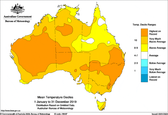
Australia’s mean temperature in 2019 was 1.52 °C above average, making it the warmest on record since consistent national temperature records began in 1910 and surpassing the previous record of 1.33 °C above average set in 2013.
Meanwhile the national average rainfall total in 2019 was 277 millimetres, the lowest since consistent national records began in 1900. The previous record low was 314mm set during the Federation drought in 1902.
Bureau of Meteorology head of climate monitoring Dr Karl Braganza said the record warm and dry year was one of the key factors influencing recent and current fire conditions in large parts of the country.
“2019 was consistently warm, but it was book-ended by periods of extreme heat,” Dr Braganza said.
“January last year was the warmest month Australia has ever recorded, while just a few weeks ago in December, we saw the Australia-wide record hottest daily average maximum temperature broken multiple days in a row.
“At the same time, rainfall deficiencies across large parts of eastern Australia have continued to increase, unfortunately exacerbating both drought conditions and the current bushfires.”
Dr Braganza said there were multiple factors influencing Australia’s weather patterns in 2019.
“Most of this year, Australia’s climate has been dominated by a very strong positive Indian Ocean Dipole, which acted to both warm and dry Australia’s landscape, particularly from around the middle of the year.
“We also saw the influence of a rare Sudden Stratospheric Warming event high above the south pole, which acted to push our weather systems northward and compound the warmer and drier than average conditions over southern Queensland and New South Wales during spring, amplifying the fire weather.
“The other key factor at play is that Australia’s climate has warmed by more than a degree since 1910, which means very warm years like 2019 are now more likely to occur, while the trend in recent decades has been for drier winter and spring seasons in the south.”
Last year also saw some periods of significant rain in northern Queensland and northwest Western Australia.
“In January and February, we saw exceptional rainfall have a major impact on communities in northern Queensland, particularly around Townsville.
“The flood waters were so significant they eventually made their way to South Australia, where we saw one of the largest fillings of Kati Thanda – Lake Eyre in many years.”
In recent weeks, some of the key drivers of the recent warm and dry patterns over Australia have eased.
As a result, rainfall for the coming months is expected to be average to below average in the east, while wetter than average conditions are possible for much of Western Australia and South Australia. However, temperatures are likely to remain warmer than average over the rest of summer.
“Unfortunately, the outlook is not indicating a widespread return to wetter than average conditions over drought and fire affected parts of eastern Australia. But with the likely return of the monsoon by mid-January for northern Australia, it raises the chance that we could see some periods of higher rainfall move south in the coming months,” Dr Braganza said.
“It’s important the community remains vigilant to the risk of more heat and fire days this summer, particularly given how dry the country has been over the past 12 months.”
State summaries
NSW
- Warmest and driest year for New South Wales as a whole.
- Mean temperature 1.95 °C above average, exceeding the previous record from 2018 by almost 0.3 °C.
- Sydney’s mean maximum temperature the warmest on record.
- Total rainfall below average in Sydney, despite a wet March, June and September.
ACT
- Rainfall well below average, particularly in winter and spring.
- Canberra Airport’s driest year since 1982.
- Annual mean maximum temperature at Canberra Airport the warmest on record, with every month above average.
VICTORIA
- Victoria’s fifth-warmest year on record overall, with the State’s mean temperature 1.05 °C above average.
- Victoria’s tenth-driest year on record, with rainfall below average for most of the State, and very much below average in the north and over Gippsland.
- Melbourne’s mean temperature above average.
- One of the driest years on record for central Melbourne.
QUEENSLAND
- Sixth-warmest year on record for Queensland as a whole, with the mean temperature 1.27 °C above average.
- Persistently dry in southeast Queensland, with many sites having their driest year on record.
- Flooding across northern Queensland and the Gulf Country in January and early February.
- Brisbane’s mean temperature and mean maximum temperature both warmest on record.
- Brisbane’s total annual rainfall well below average.
WESTERN AUSTRALIA
- Warmest and second-driest year on record for Western Australia as a whole.
- Severe tropical cyclone Veronica in March brought significant rainfall along the Pilbara coast and adjacent inland.
- Perth Metro’s mean maximum temperature equalled the record highs of 2011 and 2012, but nights were close to average.
- Perth Metro’s third-driest year on record.
SOUTH AUSTRALIA
- Driest and second-warmest year on record for South Australia as a whole.
- South Australia’s mean temperature was 1.45 °C above average.
- Adelaide had its hottest day on record on 24 January, and every month apart from August had a mean maximum temperature above average.
- Rainfall in Adelaide was well below average, including a record dry January to April.
TASMANIA
- Tasmania’s overall mean temperature was 0.41 °C above average, not as warm as recent years.
- Rainfall below average for most of the State, but above average in the west.
- Hobart’s mean maximum temperature highest on record, with overnight temperatures a little above average.
- Hobart had its second-driest year on record, with only 2006 drier.
NORTHERN TERRITORY
- Second-warmest year on record for the Northern Territory as a whole.
- Rainfall well below average for most of the Northern Territory away from the Queensland border.
- Darwin’s second-driest year or record.
- Darwin’s mean maximum temperature second-highest on record, but overnight temperatures close to average following many cool nights during the dry season.
Source: Bureau of Meteorology
Read the Annual Climate Statement 2019 and watch the summary video: http://www.bom.gov.au/climate/current/annual/aus/
Click here to download the 2019 annual climate facts and events infographic.
Climate summaries for each state and territory can be found at: http://www.bom.gov.au/climate/current/
HAVE YOUR SAY