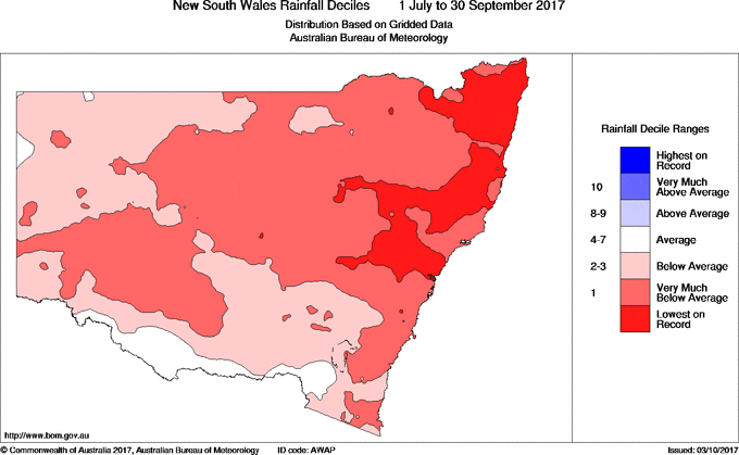
Spring started where the dry winter ended, with below average rainfall across 92 per cent of the state making for the driest September on record.
The July to September period was the second driest on record, with rainfall across the state as a whole 65 per cent below average.
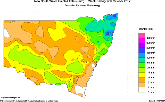
NSW Department of Primary Industries (DPI) Seasonal Conditions Coordinator Ian McGowen said most of the state received less than 10 mm of rainfall during September.
“The locations that received the most rainfall included the alpine areas, southern tablelands, the south of the central tablelands and areas of the northern slopes, lower Hunter Valley, Monaro and the far south east,” Mr McGowen said.
“Daytime temperature records were also broken with the state experiencing two of the hottest September days on record.
“Pasture growth remained low to moderate in some areas of the south and south east, but declined across most of the state as a result of the continued warmer than normal daytime temperatures combined with a lack of soil moisture, frosts and grazing pressure.
“In most areas winter crop yields were seriously affected by the combination of extremely dry conditions, frequent severe frosts and the extreme daytime temperatures during September.
“Where severely affected crops had sufficient biomass, they were cut for hay or silage. In many cases crops were grazed out to compensate for poor pasture production or to reduce the need for hand feeding livestock.”
Mr McGowen said the rainfall received in early October was very welcome, but unfortunately came too late for most crops, with potential yields already severely affected.
“However, the rain will benefit later maturing crops in areas of the south west slopes, the south east of the Murray Valley and the eastern Riverina and will allow for improved yields in surviving crops in other areas,” Mr McGowen said.
“Harvest has commenced in the north west for canola and barley crops.
“The prospects for dryland summer cropping across much of the north west have improved due to the 25-100 mm of rainfall received in early October, with some areas receiving heavier falls. However, more rainfall is still needed to replenish depleted subsoil moisture reserves.
“Perennial and summer-growing pastures are responding well to the early October rainfall, particularly across the tablelands and slopes, but follow up falls will be necessary to sustain pasture growth.”
The Bureau of Meteorology’s seasonal rainfall outlooks for the October through to January period indicate there is a near-equal chance of drier or wetter than normal conditions across most of NSW.
There is a near-equal chance of cooler or warmer than normal daytime temperatures across most of NSW. Warmer than normal daytime temperatures are likely across areas of the south east, south and central coast and Murray Valley in the October to December period.
During October, wetter than normal conditions as well as cooler than normal daytime and overnight temperatures are likely across most of NSW. However, the rainfall outlook for November is for a near-equal chance of drier or wetter than normal conditions across most of NSW.
The Pacific Ocean remains in an El Niño Southern Oscillation (ENSO) neutral state, with the outlook from most global climate models suggesting either a late, weak La Niña event or ENSO neutral conditions are possible during spring. Late occurring La Niña events have historically been variable in their effects, and may not necessarily result in increased rainfall.
As conditions across much of the state are dry, primary producers are encouraged to visit www.droughthub.nsw.gov.au the one-stop-shop providing a range of services and support to assist farming families and farm businesses to prepare for and during dry times.
Source: NSW DPI. Primary producers can keep updated on NSW climactic conditions through the monthly seasonal conditions report available on the DPI website www.dpi.nsw.gov.au


HAVE YOUR SAY