LARGE parts of central Australia are likely to have a drier than average autumn, while Tasmania is likely to have a wet autumn, according to the Australia’s Bureau of Meteorology’s latest climate outlook.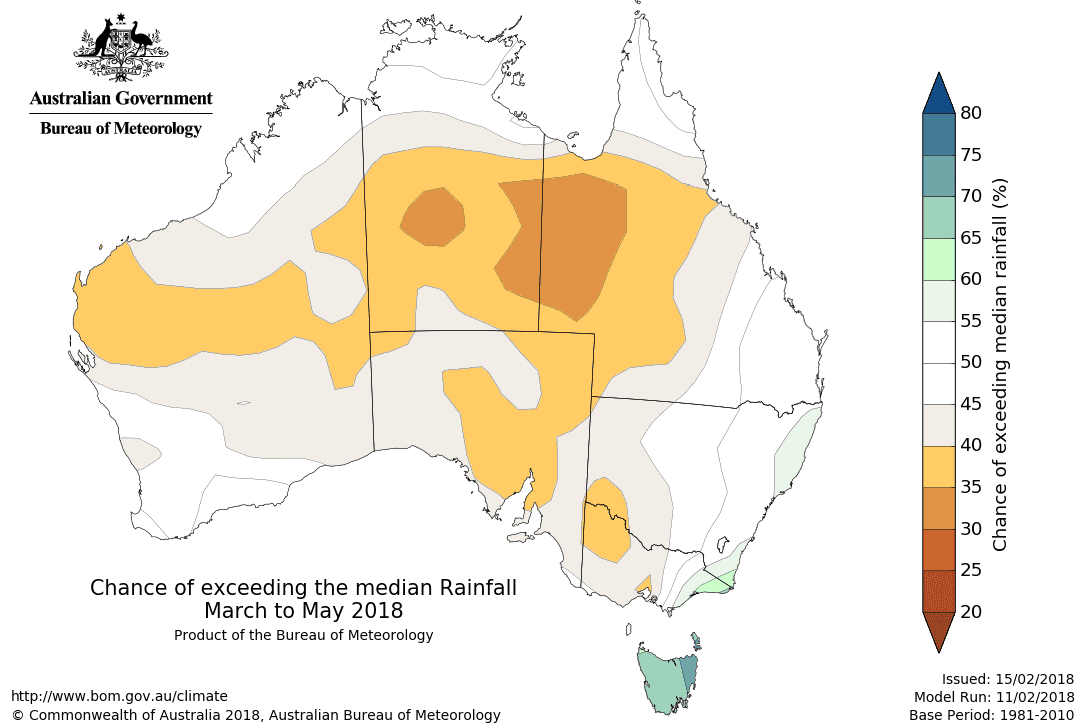
Climate outlook overview
- The autumn (March to May) rainfall outlook, issued 15 February 2018, shows large parts of central Australia are likely to have a drier than average autumn, including the southern Northern Territory, western Queensland, northwest Victoria and scattered parts of eastern South Australia and Western Australia. Tasmania is likely to have a wetter than average autumn.
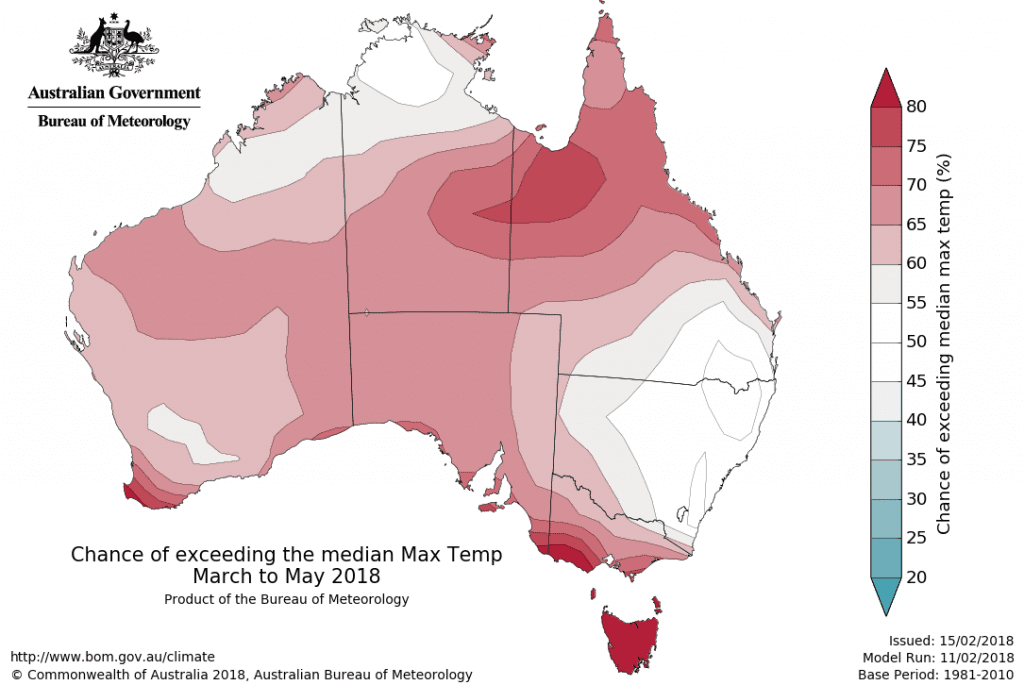
- March to May daytime and night-time temperatures are likely to be warmer than average for the northeast, central and southern parts of Australia. The northwest and parts of the east have roughly equal chances of a warmer or cooler than average season.
- The La Niña in the tropical Pacific Ocean continues to decline. This weak event has had little effect on Australian climate and is expected to decay by early autumn. See the Climate Influences section for more information.
Drier autumn likely for parts of the inland north, and parts of the southeast
- A drier than average March to May is likely for large parts of central Australia, including the southern NT, western Queensland, northwest Victoria and scattered parts of WA and eastern SA. Tasmania is likely to have a wetter than average season.
- The La Niña in the tropical Pacific Ocean continues to decline. This weak event has had little effect on Australian climate, and is expected to decay by early autumn.
- Historical outlook accuracy for autumn rainfall is moderate across most of Australia, except for southern WA and southwest SA where accuracy is generally low to very low.
Warmer autumn likely for northeast, central and southern Australia
- Both daytime and night-time temperatures for the season are likely to be warmer than average in the northeast, central and southern parts of Australia. Eastern NSW, southeast Queensland and northwest Australia have roughly equal chances of a warmer or cooler than average three months.
- Historical accuracy for maximum temperatures is moderate over most of Australia, except southern WA and central SA, where accuracy is low. Minimum temperature accuracy is moderate for the northern half of Australia, Tasmania and southern Victoria. Elsewhere, accuracy is low to very low.

Climate influences
- The La Niña in the tropical Pacific Ocean continues to decline. Recent weakening of the trade winds in the western Pacific may hasten the return to neutral El Niño–Southern Oscillation (ENSO) conditions. This weak La Niña has had correspondingly weak impacts on Australian climate, and is expected to end by early autumn.
- The breakdown of several weak La Niña events in the past (e.g., 1907, 1925, 1930, 1943, and 2009) also saw dry conditions in some areas during autumn.
- This outlook is showing little signal from any of the typical Australian climate drivers, with most in a neutral phase. Therefore other ocean and atmosphere patterns are likely to determine the likely rainfall/temperature outcome.
- In addition to the natural drivers such as the El Niño–Southern Oscillation and the Indian Ocean Dipole, Australian climate patterns are being influenced by the long-term increasing trend in global air and ocean temperatures.
- Bureau climatologists continually monitor the climate for any significant developments, with information on El Niño/La Niña and IOD events available fortnightly via the ENSO Wrap-Up.
Source : Bureau of Meteorology
HAVE YOUR SAY