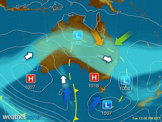
A broad low pressure trough is triggering rain and storms over inland parts of NT, QLD, northern NSW and SA. Another trough is producing a few showers in western SA. Moist southerly winds are bringing the odd shower to the coasts of eastern VIC, southern NSW and southern WA – Weatherzone, 11:44am Tuesday
A major winter rain event has begun and will continue across eastern states during the next two days.
Rain and thunderstorms have already started in parts of Queensland and New South Wales under a thick band of cloud. Bedourie in southwest Queensland picked up 34mm in the last 24 hours, which is five times the monthly average for this time of year. South of the border Narrabri collected 39mm, the heaviest rain in seven months and the best August fall in 13 years.
This rain combined with what is expected during the next 48 hours has prompted flood watches in both states. Minor river flooding is possible in the Dumaresq River Catchment and minor to moderate in the Macintyre River Valley.
This winter soaking is being driven by a broad trough of low pressure and associated upper-level cold air, which are tapping into copious amounts of moisture in the air over eastern Australia.
As the trough moves further east today, a band of rain and storms will spread through western, southern and central Queensland and northern New South Wales. The heaviest falls are likely to be in Queensland south of a line from about Mount Isa to Goondiwindi, before spreading into the state’s southeast and northeast New South Wales tonight.
On Wednesday the main band of rain will continue to spread through central and eastern Queensland and northeast New South Wales. At least one and possibly two low pressure systems will develop somewhere between Fraser Island and Wollongong tomorrow as well. These systems will help to produce rain along the eastern seaboard, although their position will determine where the heaviest falls develop. Both Brisbane and Sydney are likely to receive rain from this event despite a dry start this morning.
By the end of Wednesday, 30-50mm of rain will have accumulated through parts of western and southern Queensland as well as northern and eastern New South Wales. Some areas could see 100mm which would cause both river and flash flooding.
Rain will ease over Queensland during Thursday as the trough and low move offshore. Most of the state will be dry on Friday.
Rain should also ease in New South Wales during Thursday, although there is some uncertainty regarding the movement of the second low. Showers and storms could linger in eastern districts during the remainder of the working week, although drier weather looks to return on the weekend.
Source: Weatherzone
HAVE YOUR SAY