April-June 2020 rainfall outlook
Wetter April to June for western and southern Australia
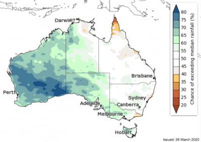
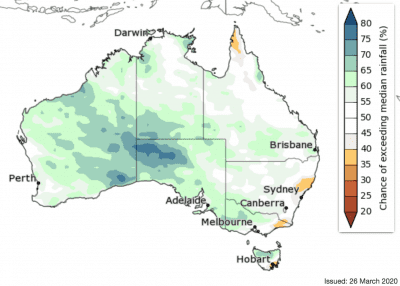
April rainfall is likely to be above average for WA, the western and southern NT, SA, and scattered parts of southern Queensland, NSW, Victoria and Tasmania (mostly 60–75% chance, greater than 75% chance in southern WA). Drier than average conditions are likely in along parts of Queensland’s east coast (60–70% chance).
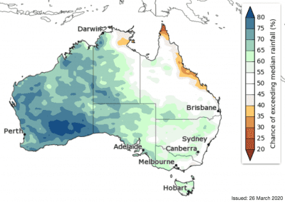
The three months April to June are likely to be wetter than average across WA, the western and southern NT, most of SA, western and central Victoria, and northwest Tasmania (60–70% chance, greater than 70% chance in southern WA). Northern Cape York Peninsula in Queensland is likely to be drier than average.
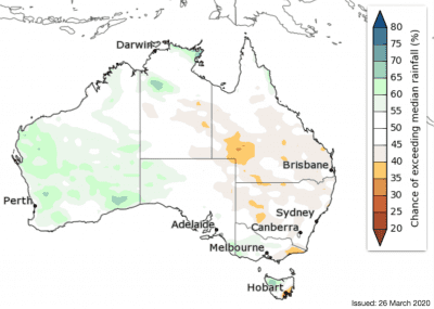
Similarly, May to July is likely to be wetter than average for much of western, central and southern Australia (mostly 60–70% chance). However, accuracy is lower at this time of year, so some caution should be exercised when using this outlook.
The rainfall outlook suggests the autumn break for southern cropping regions may occur closer to its average time this year.
‘First look’ May to July rainfall outlook:
Warmer April to June likely for most of Australia
The fortnight of 30 March to 12 April is likely to be cooler than average across southern Australia, with temperatures more than 2 degrees cooler that average in southern SA extending into southeast WA.
However, northern Australia is likely to be warmer than average.
Night-time temperatures for this fortnight are likely to remain average to warmer than average across the country.
Daytime temperatures for April to June are very likely to be above average across northern and eastern Australia (greater than 80% chance for most areas). Parts of southern WA, which may see more cloud and rainfall, are likely to have cooler than average days.
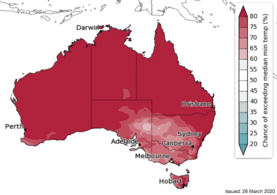
April to June night-time temperatures are very likely to be warmer than average for most of Australia (60–80% chance in the southeast, greater than 80% chance elsewhere).
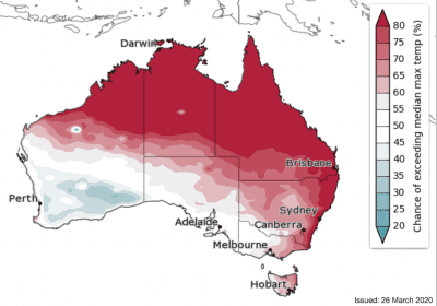
Chance of exceeding median minimum temperature
Source: Bureau of Meteorology. To view more outlook maps for coming weeks and months click here
Previous forecast versus actual rainfall
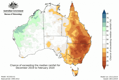
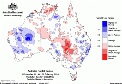
Maps below compare BOM’s rainfall forecast for December 2019 to February 2020, issued 28 November 2019, with actual rainfall recorded over the December 2019 to February 2020 period.
FORECAST MEDIAN RAINFALL DEC 2019 to FEB 2020:
ACTUAL RAIN RECORDED DEC 2019 to FEB 2020
Source: Bureau of Meteorology

HAVE YOUR SAY