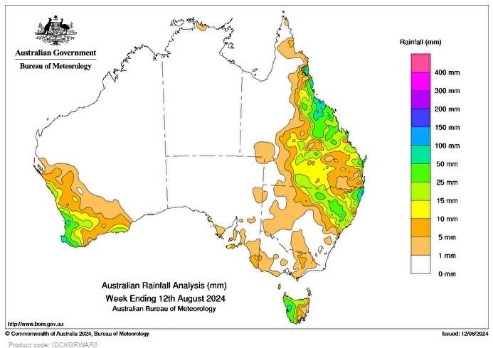
A LOW-PRESSURE trough and associated cloud band brought rainfall to north-eastern New South Wales and south-eastern Queensland on August 5, with daily rainfall totals of 10-50mm in the 24 hours to 9am on August 6.
A cold front moved across south-west Western Australia, bringing damaging winds and widespread rainfall totals of 15-50mm in the 24 hours to 9am on August 7.
At the end of the week, an upper-level trough interacting with onshore easterly flow generated widespread showers across coastal areas of Qld and north-eastern NSW, with daily rainfall totals of 15-100 mm in the 24 hours to 9am on August 12.
Rainfall totals of 25-50mm were recorded across western Tasmania, north-eastern NSW, central and northern coastal areas of Qld, and south-west WA.
Elsewhere, there was little to no rain.
Rainfall totals of 50-100mm were recorded in isolated pockets of western Tas, the Northern Rivers district of NSW, Qld’s North Tropical Coast and Tablelands district, and south-west WA, with some areas receiving more than 100mm.
The highest weekly rainfall total at a bureau gauge was 163mm at Rosebank (Repentance Creek), NSW.
The highest daily rainfall during the week at a bureau gauge was 157mm at Evans Head RAAF Range AWS, NSW, in the 24 hours to 9am on August 12.


HAVE YOUR SAY