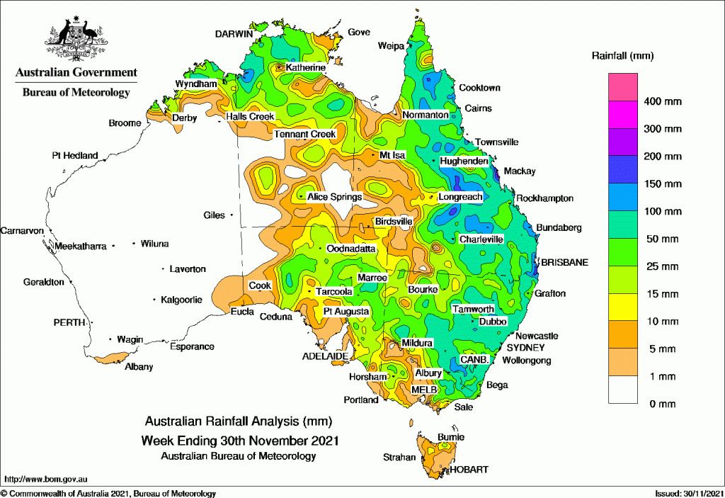
RAIN was widespread throughout the eastern two-thirds of the continent over the past week with parts of Queensland, New South Wales and the Northern Territory recording more than 100 millimetres.
Early in the week a large high pressure system in the Tasman Sea directed a moist airstream over the eastern states.
Mid-week a low pressure system developed over north-western NSW, bringing moderate falls to most of NSW, Victoria and central and eastern Queensland.
Later in the week, troughs directing onshore flows produced thunderstorms and further showers in eastern Queensland and north east NSW.
Thunderstorms were widespread throughout the north-west Northern Territory and Kimberley in Western Australia throughout the week.
Past seven days: For the week to 30 November 2021, rainfall was recorded in most of the eastern two-thirds of the Australian mainland, as well as the Kimberley in Western Australia.
At the start of the week, a cold front moved across South Australia and the southern Northern Territory. A trough was located across northern and eastern Australia. A secondary trough formed along inland northern Queensland, while a large high pressure system in the Tasman Sea directed a moist onshore airstream over eastern states. Thunderstorms and showers saw moderate falls recorded in the north Kimberley in Western Australia, across much of the Northern Territory, South Australia, and eastern mainland.
During the middle part of the week, a low pressure system developed in the north-western New South Wales. The low and associated cold front and trough moved slowly across New South Wales and southern Queensland. Widespread moderate rainfall was recorded across most of New South Wales, much of Victoria, central and eastern Queensland. Locally heavy daily falls of 70 mm to 150 mm were recorded in the Hunter region in New South Wales and the north-east of Victoria. Thunderstorms with showers continued in the north-west Northern Territory and the Kimberley in Western Australia.
In the last part of the week, a surface trough, combined with an upper level trough, and assisted by an onshore flow, produced thunderstorms and showers across the eastern half of Queensland and north-east New South Wales. Daily falls of 100 mm to 230 mm were recorded in the Central Coast and Central Highlands districts in Queensland.
Rainfall totals in excess of 100 mm were recorded in areas in central and along the east coast of Queensland, small areas in the far north-east, central and south-east of New South Wales, and a small area in the north-west of the Northern Territory. The highest rainfall for the week was 351.4 mm at Farleigh Co-Op Sugar Mill in the Central Coast in Queensland.
Rainfall totals between 50 mm and 100 mm were recorded in the north Kimberley in Western Australia; areas in the north-western and eastern Northern Territory; north-eastern South Australia; central and eastern Queensland; central and eastern New South Wales, and north-eastern Victoria.
Rainfall totals of 10 mm to 50 mm were recorded across most of the eastern two-thirds of the mainland, extending to the Kimberley in Western Australia. Areas in the north of Tasmania recorded similar weekly rainfall totals.
Highest weekly totals
New South Wales and Australian Capital Territory
240 mm Yarras (Mount Seaview)
218 mm Mooral Creek (The Den)
189 mm Upper Pappinbarra (Hillcrest)
Victoria
20 mm Combienbar AWS
18 mm Falls Creek
17 mm Mount Buller
Queensland
129 mm Hawkins Creek
128 mm Southwood
125 mm Bundaberg Aero
Western Australia
67 mm Cunyu
64 mm Eucla
58 mm Neds Creek, Denbarker
South Australia
43 mm Maralinga, Mount Ive
42 mm Nullarbor
Tasmania
36 mm Mount Barrow (South Barrow)
35 mm Mount Read
32 mm Fern Tree (Westringa Road), kunanyi / Mount Wellington
Northern Territory
48 mm Bradshaw
35 mm Labelle Downs
32 mm Pirlangimpi Airport
![]()
HAVE YOUR SAY