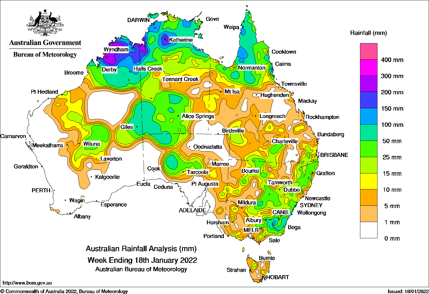
Tropical cyclone Tiffany produced widespread rainfall across northern and central Australia, while troughs brought showers and thunderstorms to eastern Australia.
Past seven days: At the start of the week, ex-tropical cyclone Tiffany re-intensified to a tropical cyclone as it tracked west across the Gulf of Carpentaria. A monsoon trough extended across the Cape York Peninsula in Queensland to the Coral Sea. Tiffany crossed the Carpentaria District coast in the Northern Territory south of the Roper River as a category 1 system on the 12th. Tiffany soon weakened and tracked slowly west across the base of the Top End. Widespread moderate to locally heavier falls were recorded in the Top End, and the Carpentaria District in the Northern Territory, the Kimberley in Western Australia, the Gulf Country and the Cape York Peninsula in Queensland. A surface trough extended from south-west Queensland, through northern to the east coast of New South Wales. Thunderstorms developed along the trough and produced moderate falls in north-western, central and eastern New South Wales, and eastern Victoria
By mid-week, the remnants of ex-tropical cyclone Tiffany were located in the Kimberley in Western Australia. Moderate to locally heavier falls were recorded in the Kimberley and western Top End. Moderate rainfall was also recorded in the Pilbara coast and the Southern Interior District of Western Australia, and the south-west of the Northern Territory. The surface trough extending through inland eastern Australia produced showers and thunderstorms with moderate falls in northern, central and southern inland parts of Queensland, from central to south-east New South Wales, and the eastern half of Victoria.
In the last part of the week, the remnants of ex-tropical cyclone Tiffany drifted south-east and later formed a complex low pressure system in central Australia at the end of the week, and brought widespread moderate falls to southern parts of the Northern Territory, central and eastern parts of Western Australia, and northern and central South Australia. Thunderstorms with moderate falls were recorded in eastern New South Wales and south-eastern Queensland as the trough moved to the coast.
Rainfall totals in excess of 200 mm were recorded in the Kimberley in Western Australia, and the Gregory District in the Northern Territory. Isolated totals in excess of 200 mm were also recorded in the north tropical coast of Queensland. The highest weekly total was 275 mm at Maranboy Hill (east of Katherine) in the Northern Territory.
Rainfall totals in excess of 100 mm were recorded across most of the Kimberley, parts of the Top End and south-west areas in the Northern Territory, pockets of the Cape York Peninsula and north tropical coast of Queensland, and an area of the Snowy Mountains in New South Wales.
Rainfall totals between 50 mm and 100 mm were recorded in much of the northern tropics, areas on the Northern Territory–South Australia–Western Australia border, agricultural districts of South Australia, south-east New South Wales and north-east Victoria.
Rainfall totals of 10 mm to 50 mm were recorded in most remaining areas of northern Western Australia, most of the Northern Territory, northern and southern Queensland, most of New South Wales, eastern and southern parts of Victoria, and a small area of north-west Tasmania.
Highest weekly totals
New South Wales and Australian Capital Territory
131 mm Sanctuary Point
130 mm Thredbo Village
125 mm Thredbo AWS
Victoria
91 mm Dartmouth Reservoir
79 mm Hunters Hill
61 mm Mount MoornapaCombienbar AWS
Queensland
257 mm South Johnstone Exp Stn
176 mm Innisfail Aerodrome
125 mm Whyanbeel Valley
Western Australia
260 mm Ellenbrae
250 mm Drysdale River Station
231 mm Mount Hart Station
South Australia
72 mm Ernabella (Pukatja)
65 mm Tarcoola (Mobella)
44 mm Tarcoola (Mulgathing)Tarcoola (Commonwealth Hill)
Tasmania
53 mm Tunnack Fire Station
24 mm Kunanyi/Mount Wellington
21 mm Mount Seymour. King Island Airport
Northern Territory
275 mm Maranboy Hill
247 mm Nitmiluk Ridge
238 mm Port Keats Airport
These rainfall totals are based on real-time rainfall reports, and only limited quality control has been performed on the data. Some station names have been shortened by taking away words such as post office and airport.
HAVE YOUR SAY